Where the White Sand Begins
The pale slopes at White Sands are one stage in a longer trip. Gypsum moves through rock, dissolved material, crystals and grains before the wind gives it a dune’s shape.
In this story 5 sections
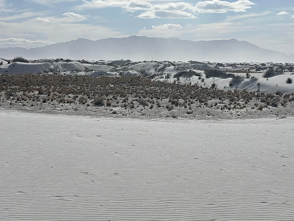
A few dark plants and a line of mountains are enough to place the white near the ground in the photograph of White Sands. Viewed on its own, a pale rippled surface might be confused with a thin fall of snow. The surface in the image is sand rich in gypsum. It takes more than wind moving sand, however, to explain why there is a field of it at the foot of these mountains in New Mexico. The texture at the front of the photograph is the last visible part of a process that begins in different places and in a different state of matter.
The National Park Service's geology account takes the history back to mineral deposits from an ancient sea. Its account of the modern basin gives water a prominent role too: water carrying dissolved gypsum can collect in areas such as Lake Lucero, leave minerals behind as it evaporates and contribute to a supply of crystals broken down into sand. Neither the ancient sea nor the location of precipitation is visible in every photograph of a dune. To understand a dune here, follow both the history of the material and the route it can take now.
Begin with a basin instead of a pile of grains
A dark shape at the edge of the landscape can mark a mountain range without showing how the lower ground between ranges is organised. Water moving from the surrounding ground enters a basin whose shape affects where that water and its dissolved material go. The Park Service describes former Lake Otero in this basin and identifies Lake Lucero and the Alkali Flat as parts of the more recent story of gypsum accumulation. Reading the basin this way connects the present dry scene with conditions that make a lake possible at another time.
A map that shows a lake only when it is full can miss an important part of this relation. A dry-looking low area may still belong to a water system. Under some conditions incoming water occupies it. As water goes, minerals can remain. The same outline on the map might thus describe a low place with different appearances across the year. A dated description makes that variability more informative than a blue symbol giving a general sense that there is always a lake.
The source area is not the entire dunefield. That distinction is useful even if both appear pale at a distance. One part of the story involves where gypsum comes out of water or becomes available to be broken down. Another concerns where sand accumulates once moved by wind. A view of the dunes that leaves the source outside the frame does not erase that difference. It makes the benefits of a basin map clearer.
The material changes how it can travel
Gypsum in solution does not make little sand grains necessarily visible in the water. After evaporation, crystalline material can collect in a form that is recognisable on the surface. Weathering breaks it into smaller pieces. The Park Service describes wind and water contributing to that breakdown, producing particles small enough to move as sand or dust. The mineral can persist through these changes without every form having the same route.
This is a useful place to be careful with verbs. Water carrying dissolved material is not simply rolling finished dunes downhill. A gust moving grains is not creating the entire mineral supply in that instant. The particles are available to the wind after other processes have released or reduced them. The descriptions fit together because the output of one process becomes available to another. A time series showing only a ripple shifting would document that last movement well.
A broad geologic history gives the same material several time scales. The deposits in rocks have a history far older than a single present day dune. The route through water and crystals can recur. A ripple on the surface can change on much shorter intervals. Calling White Sands old or new without naming the part under discussion collapses those scales. The right question might concern the age of a deposit, the recent water level or a newly moved line of sand.
Wind can reshape what it did not originate
A wind moving loose grains can transport them downwind. Where sand collects, the surface changes and begins affecting the flow of subsequent air and grains. As the conditions vary, the field of forms can include different sorts of dunes. The National Park Service's monitoring protocol distinguishes crescentic and parabolic forms, among others in its account. Their outline and how the ends relate to the direction of movement are useful clues. A single photograph taken at ground level need not give enough information to classify everything in view.
Vegetation and moisture provide another pair of considerations. A surface with plants and a surface of mostly loose sand can respond differently. The monitoring protocol treats vegetation and moisture as part of evaluating the dunefield's condition. In the cover photograph plants mark darker uneven ground between stretches of sand. This contrast is worth observing without assigning a recent direction of movement from colour alone. It shows that the view contains more than a uniform pile of loose minerals.
Try drawing one crest on an image and the same feature on an independently timed image of the area. Before comparing, align the views using relevant landmarks and note whether the camera stood in the same place. A changed perspective can make the toe of one dune overlap another. A survey intended to track movement needs ways to distinguish that optical change from displacement. One attractive photograph is most useful for identifying questions about height, overlap and the scale at which the landscape should be watched.
Dry sand sits in a landscape where water still matters
There is no conflict in saying that the foreground looks dry and water is essential to the story. The description names different observations. A footstep on a dry ridge encounters grains at that ridge. Water in the basin helps explain how a new supply of mineral can be left behind after evaporation. Below the visible surface, moisture can have different implications from an absence of anything wet at eye level. A photograph with no open pool is consistent with a landscape shaped in part by intermittent water.
A similar distinction helps when comparing dunes in other places. A desert surface can be pale for more than one reason, and dune shapes do not identify the mineral by themselves. Here the gypsum source is supported by the regional geology and the Park Service's discussion of modern processes. Elsewhere a similar ripple could belong to material created in another way. Shape is a good start in reading a landscape. It works best beside evidence about composition rather than as a replacement for it.
Give the visible surface a longer address
A map prepared to show how the sand is made can colour territories differently from a general map of the park. One shading may describe a source of mineral, a second may give places at which grains can accumulate and a third may show the shape of a crest at some stated date. If two areas have the same white colour in a photograph, that does not require them to occupy the same category. Each shading is a hypothesis or observation about a process. This is a practical reason to put a date and definition in a legend rather than add a swatch that simply says white ground.
The old Lake Otero provides a useful historical comparison. The Park Service's account describes it as a much larger body of water that occupied a substantial part of the basin. Using its outline to explain the origin of some present surfaces is different from drawing that outline as a lake the visitor can see now. In one case the map is describing a past extent and the mineral landscape it helped leave. In the other it would be giving present surface conditions. The same map can support both stories if there is room to say when each line belongs.
It is possible for a source to be available repeatedly without yielding the same amount of material every time. The agency describes periodic filling and evaporation. Variations in water and wind affect which stages are visible or active, not necessarily in step with changes in a single dune. Keeping several dates side by side can therefore be more useful than assigning one simple rate to the whole dunefield.
One place to start a diagram is the dune, because that is what a person can see. Draw a line back from the moving sand to the exposed material from which grains can be produced. Draw another back to the water and rock that carry and supply the mineral. The lines will not all represent the same physical process. Writing the verbs beside them makes the sketch much more helpful: the material can dissolve, collect, crystallise, break down and move again.
The white foreground is only one place at which to pause in that sequence. The mountain and basin behind it help give the sand a geographic address. The lake or flat may supply a closer source than a glance at the distant skyline would suggest. The ripples give a brief clue to conditions at the visible surface. Together these features describe a landscape more interesting than a lucky colour in the desert. It is a set of connections that can keep making and rearranging the same kind of grain.