The Tree Line Below Mount Kenya
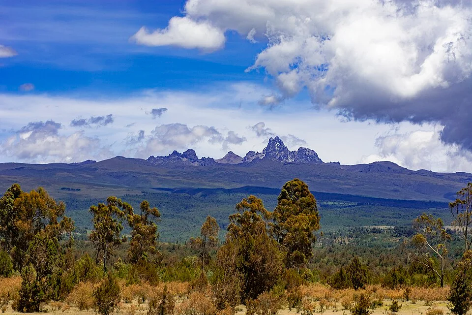
From Timau Forest, dark woodland and jagged peaks seem to meet in one view. Between them lie several different transitions.
In this story 5 sections
From the Timau side, Mount Kenya appears above a broad dark shoulder. Near the camera, individual crowns and gaps are easy to make out. Higher up, the slopes recede into blue and the shape of the rock is easier to see than the shape of a plant. The picture has two obvious subjects, trees below and peaks above. The most difficult part to read is the ground in between, where trees give way to other kinds of vegetation long before bare rock takes over.
If we were looking for a line with a ruler, we might lay it along the point at which the dark color seems to end. At the distance of the photograph, color cannot tell us that every stand on one side has trees or that none grow on the other. A shallow valley can lie out of sight behind a fold in the slope. A grassy space or a patch of young growth can sit inside country that is otherwise wooded. That makes the view from Timau a good introduction to the idea of a tree line: it lets us see why the term is useful and why it is not always an easy thing to draw on the ground.
Which trees mark the limit?
A field observer can ask where a closed forest gives way to separated clumps, or how high the largest individual trees survive. Those observations can give different elevations. A stand dense enough to shade its own floor is a different physical setting from a handful of stunted stems separated by grass. At the upper margin, conditions near a sheltered rock or a small ravine can differ from conditions on the adjacent open slope. The presence of a few trees says something about the place they found to grow; it does not turn the whole hillside into forest.
The IUCN evaluation of Mount Kenya describes the sequence from mountain forest through forest near the timberline to heath and high moorland. Seen up close, it is possible for the transition to change character several times over a short walk. A continuous layer of canopy thins, the ground vegetation changes and familiar landmarks stand farther apart. From a distance those changes can appear as a single stripe. The stripe is useful for orientation as long as nobody mistakes it for a very exact line of evidence.
One practical approach is to record what feature is being mapped before putting a mark on the page. A forestry map may need the upper edge of continuous cover. An ecologist interested in the persistence of a particular tree might seek the highest surviving examples and distinguish established trees from small seedlings. It would be possible to carry out both tasks on the same slope and disagree very little about what is present, yet draw two different boundaries.
Bamboo occupies some of the middle ground
The main ecological shift is easy to oversimplify when it is described from a high summit down. The UNESCO description names different forests at lower elevations according to rainfall, with drier and wetter parts of the mountain supporting different mixtures. At intermediate elevations it describes important stands of bamboo alongside characteristic forest vegetation. A band that reads as dark or dense from a distance could therefore contain plants with quite different forms from the familiar tall forest farther down.
Picture the difference at the height of a person's shoulder. A forest tree can lift most of its foliage high above open space between trunks. An area of tall bamboo can give a much closer impression of density, as upright stems fill the view. The arrangement of vegetation above the ground matters to what a person can see and to where other plants find light. On a map compiled to show only the presence of large trees, the bamboo would be represented one way. On a map of vegetated cover, it would be represented another. Neither would be a direct copy of the dark patches in a landscape photograph.
There is also variation around the mountain at any given height. A single number applied to the bamboo or to a tree line would imply a band of uniform width surrounding Mount Kenya. The World Heritage description makes clear that vegetation responds to altitude and to moisture. A profile drawn from one aspect is a profile of that aspect. Draw another one after crossing over to a different drainage and both the order of local features and the ease of separating them may change.
Height is only one of the coordinates
A contour line tells a map reader when places have the same height. It cannot tell us by itself how much wind those places get, where water collects or how long the surface stays in shade. A hollow and a shoulder can sit on the same contour. The hollow might give a tree shelter, while water running off the shoulder leaves a different surface for roots. These are plausible reasons for a break in a pattern, not enough by themselves to diagnose any particular gap from the Timau view.
There are other complications. A broad strip can have a past that differs from an apparently similar strip next to it. A disturbance can remove existing plants; the marks left afterward can last longer than the immediate event. A narrow sample through one stand could find a tidy sequence that becomes more complicated over a whole slope. For an account of the mountain, it helps to keep present conditions and past changes separate. A good description of what is there is the beginning of the explanation.
One way to organize an observation is to describe each point by height and by slope position, then record how tall and how continuous the vegetation is. If someone returns with compatible observations from several slopes, the comparisons gain detail. The influence of a band of elevation can be considered alongside the influence of a ravine or a change in exposure. A photograph can tell an observer where an interesting change might be worth a closer look. It cannot supply the ground comparison by itself.
Open country can have a great deal growing in it
Above much of the forest cover on Mount Kenya lie combinations of heath, moorland, grasses and sedges. UNESCO describes several kinds of high vegetation rather than a single open zone. That distinction is easy to miss when the main question is simply where the trees end. Bare stone near a summit, a tussock grass slope and a wet sedge patch are different places. Each can contribute a pale or open shape from far away.
It helps to turn the familiar picture around. The plants in the high country occupy particular sites and make a landscape of their own. Consider where standing water or saturated ground persists, and where that gives way to a drier rise. Even on a slope with almost no tall trees, those small differences can produce sharp boundaries between adjacent communities. The question about trees guided us up the mountain. A question about water, height or the shape of the ground can make the upper landscape easier to read after that.
On a far view the peaks look more durable than the color of the plants in front of them. For a repeat picture, use a similar position and remember the effects of light, cloud and season. Those factors affect how a boundary looks; they may account for a visible change before anyone needs to infer an ecological shift. Records made on the ground can then show whether individual plants, clumps or a more continuous belt occupy a different place. It takes complementary observations to ask whether a particular edge is moving.
Follow one ridge back to the photograph
Pick a place in the Timau view with a crown standing out against a lighter slope. Trace the tree back toward the visible ground before deciding which ridge it belongs to. The scene would look different if the camera were down among the trees or looking across the mountain from the other side. Near objects would hide some of the far ones. Terrain that reads as a horizontal stripe from Timau could be made of slopes tilted in several directions. This is ordinary perspective, but it has consequences for anyone using a landscape as evidence.
If a second image were taken from across a valley, it might show the dark area continuing up beside a watercourse that was concealed in the first image. It might instead show a sharp edge unrelated to the feature that first caught the eye. A paired view would make it easier to distinguish the geometry of the land from the arrangement of the plants. A map can hold both pictures in place by showing what parts of the same ridge each one sees.
Take one last look at how much territory separates the trees near the camera from the high points. An unbroken vertical journey through that space would pass several kinds of vegetation, some quite unlike the ones visible to the viewer. Some of the plants that make up the highest patches would only be distinguishable at close quarters. The tree line works in a description when we specify what is ending there. The photograph is equally good at reminding us how much begins after that.