The Fog That Reaches the Atacama
Low cloud off northern Chile can meet a coastal hillside without bringing measurable rain. A view from the air gives the cloud its width; a view from the ground explains where it becomes fog.
In this story 5 sections
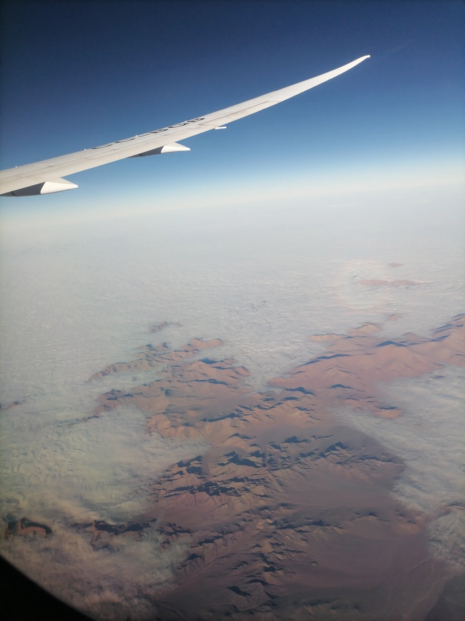
The aircraft wing points out over a broad patch of pale cloud in Carlos Teixidor Cadenas’s photograph. Below it the dry surface appears through gaps. Some of the reddish land is easier to see at the bottom of the frame, where cloud forms an uneven edge. There is no reason for the airborne observer and someone standing on a hillside below to give the white layer the same name. From the plane it is a low cloud bank. At a level where the same cloud intersects the ground, water droplets hang in the air around a person standing there. It can be fog at the surface without being rain.
Along parts of northern Chile, coastal fog is often called camanchaca. Researchers studying the desert coast and mountains of Tarapacá have looked at which ground the low cloud reaches and how that changes over time. The question is more specific than asking whether the Atacama is deserted or dry. Some very dry country is close to a supply of moisture in the air above the Pacific. A strip of hillside can be exposed to it while ground nearby gets little. To see why, put a side view of the coast next to the broad view from the plane.
Look for the altitude at which they meet
A cloud is a region containing many suspended droplets or ice particles. In the case of coastal fog think primarily about droplets and the part of the air near the surface. Draw a low layer moving inland from the coast. If everything below it remains below its base, a person on the ground can see an overcast sky and stay outside the cloud. If a slope rises into it, somebody crossing that patch of hillside can enter the same layer. If the terrain extends well above its top, there may also be ground above the fog. A point higher than a foggy one does not therefore have to be foggier.
This simplified section shows why the coast cannot be understood through a map of horizontal coverage alone. Two positions equally far from the ocean might lie at different heights or have very different exposure to the incoming air. A valley or slope may affect where flow reaches. In another interval the base or top of the cloud can move. A band of ground fog is partly a moving weather feature and partly an encounter with the land fixed beneath it. Neither set of facts is enough on its own to tell which site a person might find wet.
An inversion can sometimes help restrict low marine cloud to a relatively shallow layer: think of air comparatively warm above cooler air below, rather than expecting all height to correspond to a cooler temperature. That arrangement can limit mixing upward. The thickness of the cloudy air and the position of its lower boundary can still change. What the wing photograph shows is a broad consequence of atmospheric conditions at one moment, not a measured cross section of temperature above the place. A study of fog therefore needs the same view at more than one height, or some other way to estimate where the layers lie.
Water can arrive without falling in ordinary drops
A rain gauge and a surface exposed to fog can tell different stories. The gauge is meant to count falling precipitation over its opening. Tiny droplets carried more nearly along with the air can meet a branch, a leaf or an exposed mesh and collect there. When enough are retained and gather into larger drops, water can run to another part of the surface or drip. The arrangement of the collecting surface makes a difference. The person studying fog is asking which moving air can supply droplets to exposed things. A measurement of ordinary rainfall still tells something useful, just not the same thing.
The distinction helps make sense of the contrast in the photograph. The ground does not have to turn into a broad green field before a slope can receive some moisture from low cloud. Strong differences can persist between sites with frequent exposure and nearby places sheltered from the flow or below the relevant elevations. Indeed, a study concerned with what reaches plants would need to know more than whether a dense cloud looked white from above. It would ask how often the area was in the cloud, which surfaces were exposed to it and how much water they could receive.
Fog collection installations put this relation to work by offering a surface for droplets arriving with the wind. Seeing one in a photograph would show that somebody thought the location useful for collecting. It would not establish a measured yield or show that the water was suitable for a particular use. A clear account treats the presence of fog, the amount collected and the intended application as three different questions. They can be investigated together without assuming any one photograph answers all of them.
Follow the cloud at several times
The photographed layer looks broad and fairly continuous up near the wing. On the ground, a bank can obscure a marker for a while and then uncover it. Repeat the observation on the same slope in different hours and there may be change in where it lies. Repeat it over different seasons and the frequency can change too. Research on the coastal Atacama using ground optical observations examined such differences by estimating the position and depth of low cloud over the terrain. A method like that can keep returning to the same relationship between brightness, visibility and height while weather changes around it.
One could ask why a satellite view is not the only thing needed. An image from above can offer broad coverage and make patterns that extend beyond one slope visible. It often shows the top of the cloud. A visitor in a fog bank is mainly experiencing where the layer meets the ground. A ground observation can help place the bottom and the periods of contact, but it cannot necessarily see the wider shape visible from above. The two records make different portions of a useful description. The best approach depends on which of the questions matters at that point: coverage across the desert, height at a place or exposure through time.
The photo also gives a scale that can be missing from the ground. Small changes along its edge can represent very different portions of a hillside. But it cannot tell how long a place stayed in shade or whether a long edge moved inland and then offshore again. A series of observations helps distinguish a regular setting where fog returns from a striking bank noticed once in the air. In a region where small amounts of airborne moisture can matter, the distinction has consequences beyond whether an observer remembers the weather as cloudy.
A year of observations changes the question
The ground optical study led by Camilo del Río reported less frequent fog in summer than in winter in its 2017 observations. That result concerns the places and methods it used. It is a reason to ask which dates and elevations a photo represents, rather than a rule for predicting the weather at a particular road or village. A year with numerous records can bring out an association that a single visit would leave invisible. Measurements on further dates are needed to decide how persistent the pattern is.
For a hypothetical station where somebody can make regular observations, there are at least three separate questions. Does cloud cover the ground at the height of the station? How long does that condition last each time it appears? During those periods, do exposed surfaces actually receive much water? Suppose two stations spend an equal number of hours in fog. One can be exposed to a greater flow of droplet-laden air than the other, so their collection records can differ even if the duration numbers match. The time, the weather and the position are part of the observation.
That kind of evidence also offers a way to describe a fog-dependent patch of land. One part of the county or district may have quite low rainfall in common with another. Its exposure to moisture in suspended droplets can be quite unlike the other site's. Rather than reading a single rainfall average as a complete explanation, compare the paths by which water has a chance to reach local surfaces. Around a cloud edge, the difference may be most apparent on a slope that separates two views instead of dividing two regions on a larger map.
Read the edge from below and above
The red ground in the foreground and the pale region beyond it meet in a complicated line from the viewpoint of the plane. Try to imagine one part of that line from the ground. It may be a patch where the view becomes difficult and the air carries droplets. Another part may lie just above a visible valley. What matters to the land is not that all of northern Chile has the same cover. It is that parts at particular heights can intercept what the lower cloud brings.
The name camanchaca makes that experience recognizable. A photo from a plane helps with extent and outline. A hillside account supplies height and contact, and a sequence of observations supplies timing. Taken together those views explain why the presence of water in the air and the extreme dryness of other ground in the same region can both be true at the same time.