The Salt Pattern on Salar de Uyuni
From standing height, low ridges break Bolivia’s pale salt flat into polygons. The surface owes its changing appearance to crust, brine and a water supply that does not stay constant.
In this story 5 sections
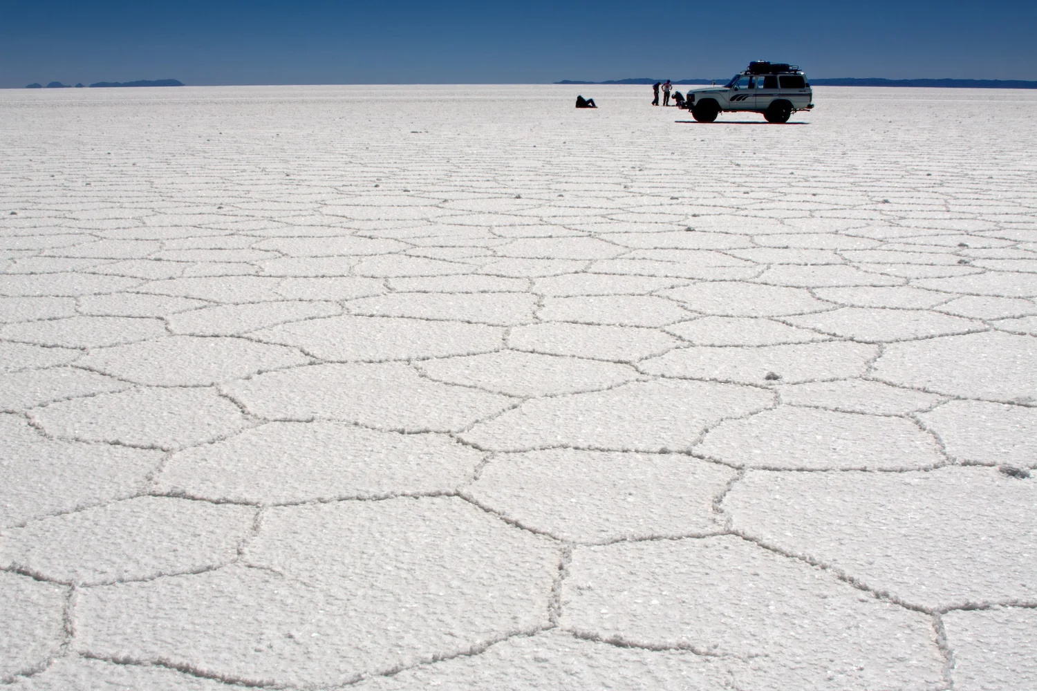
A vehicle at the far end of Pedro Szekely’s photograph sits between a white plain and a dark blue sky. The lower part of the view makes that plain look anything but blank. Fine ridges divide it into large, irregular cells. A few are easy to follow until their edges fold in with those of their neighbours. The cells get less distinct beyond the middle of the image. That is partly a question of distance and perspective. Which shapes are really present is easier to assess where the camera can make out both edges of a ridge.
Salar de Uyuni occupies part of the high plateau in southwestern Bolivia. It is a broad salt flat rather than a large open body of water all year. NASA has documented occasions when a film of water makes the landscape reflective as well as times when the crust appears dry and pale. These different views can come from the same setting. The high plateau and the weather give the salt and water a place to meet. How long water spends in that position and how concentrated it becomes belong to a history that the camera can record only in one state at a time.
First separate the basin from the surface
A basin can collect water without supplying an outlet through which it continues to the sea. Water and dissolved material arriving at points in that setting can take different paths afterward. Evaporation sends water back into the air, leaving the dissolved salts behind. As a brine becomes concentrated under suitable conditions, salts can crystallize. Occasional water over the crust can dissolve some material again and shift it. A broad expanse of salt can therefore include evidence from repeated periods, not a single crust left in one afternoon and kept unchanged since.
The flatness of the salar does not mean all conditions are the same from edge to edge. Water can arrive through particular parts of the watershed. Even a slight variation in the height of the surface can matter for a film much shallower than it is broad. A longer-lasting pool and a temporarily wet area can look similar in a brief image, especially if the difference is only a few centimetres of depth. A reading from one location should retain its position and date. A view showing the full white expanse can disguise differences that become quite important when the question concerns the way salt is deposited.
The U.S. Geological Survey’s report on highland salt flats discusses material found beneath the visible surface, including salt and intervening layers in Salar de Uyuni. That is another scale of observation. A surface ridge, the crust as a whole and deposits deeper down are useful for different questions. Read the simplest section by starting near the air and following it down through solid material and places where brine can be present. The fact that the top looks dry does not give an account of the distribution of water lower in the ground.
Inspect a ridge before giving it a cause
In the foreground of the photograph several edges appear raised or rough. A cell is not defined by a raised mark that belongs only to that one patch; an edge can divide two nearby patches. Where several meet, the shapes look remarkably orderly from afar. Up close they are neither guaranteed to have six sides nor identical in size. A plan showing hexagons is a good way to introduce the pattern and a limited way to describe the exact boundaries in the photo. There is value in tracing a few imperfect examples before describing them all with the same geometry.
It is tempting to treat any repeated polygon as evidence that one familiar thing happened, such as a surface shrinking as it dried. There are reasons to investigate cracks, precipitation of salt and water movement rather than decide only from shape. The older USGS report describes multiple kinds of surface shapes and structures across Andean salars. A report based on a broad region can supply ways to look at the photo. It cannot show in detail which of the many possible changes created each ridge in one point pictured here.
Look for another visual clue: raised ridges and shallow separations do not have the same story available to a photographer. Shadow can emphasize a positive edge at one time and reduce its effect at another. A close measurement may supply height as well as the shape in plan. A series of images can show whether the pattern stays in place, disappears for part of a year or reappears after water dissipates. The separate observations are especially useful because similar-looking outlines can be the end result of differing surface processes.
There can be movement beneath the crust
A physical study by Jana Lasser and colleagues investigated polygonal salt crusts on playas and discussed an explanation involving convection in porous ground. Its broad idea is that uneven density in liquid beneath the surface can cause circulation and contribute to variation where salt accumulates. Salt concentration near an evaporating surface can differ from the concentration at depth. The resulting exchange takes place in spaces between grains, a very different setting from a body of open water anyone could watch from the side. Under some conditions that circulation can have a repeated spatial organization.
It is an interesting explanation to set beside a photo of the Uyuni polygons. It does not make that photograph a direct observation of circulation. The research used field sites and models to study the mechanism, and one should state which evidence applies at which site. The same caution applies to the alternative idea that contraction is enough to describe all of the outlines. The surface is the part of the story readily exhibited in a photograph. An explanation of the hidden conditions needs measurements or observations able to distinguish them.
There is a geographical reason to care about these distinctions. A basin can have long stretches of crust where the material below remains connected to water. An explanation that assumes the crust is only a dry tile and that nothing below can move would miss an important potential contributor. A different patch may spend more time submerged or experience another pattern of accumulation and drying. Starting with an ordinary account of how the liquid and the crust meet helps a reader know what needs testing at the particular place.
Add an almost invisible sheet of water
At times rain covers some of the large surface in a thin layer. An image taken then can look like one broad mirror when the water is undisturbed enough to reflect the sky. The geometry under the reflection may be much less obvious to the eye. A picture made at another time can show a white plain where the division of the crust suddenly becomes legible again. Calling the two views pictures of different landscapes would miss the way the same basin can look while water alternately marks and conceals it.
A low angle makes the change particularly vivid. From a position close to the surface, a layer small in depth can occupy much of the frame. From far above, a difference in broad tone can distinguish wet ground from dry without showing individual ridges at all. Neither view is inherently better. The low view can place the small lines in a landscape. The wide view can show how much ground changed and where. Both should carry the occasion of exposure rather than being interpreted as perpetual conditions.
There is also a difference between viewing and mapping a salt flat after wetting. A still image may suggest a featureless way across the ground. From the photograph alone a person cannot establish the condition of a route, the depth of the water or what is beneath it. The attraction of the mirror image comes from how little the surface divides what lies above from what is visible below. That same property makes it a poor basis for other decisions about what is actually present.
For studies of change, comparison improves if the same patch can be located on both occasions. A nearby landmark can place a photo without making it obvious which individual surface cells it shows. Match the scale as well as the position. A view that is good enough for measuring the overall area of a flood may still be too coarse to tell whether one ridge survived it. The source of a useful answer depends on the size of the change being investigated.
The delicate line in the foreground
Return to the distant vehicle in Szekely's photograph and bring attention back to the nearest dark edge. At the scale of the horizon, there is a broad basin where the separation of weather, water and salt takes long views to understand. At the scale of a foreground boundary, one can trace where almost white ground changes direction and joins a neighbouring shape. Those are two lengths of the same study, each making visible something the other hides.
The surface can remain a recognizable salt flat through seasons in which very different details are easy to see. The polygons are worth following because they keep the observer close to the crust and the questions that belong there. A basin can be vast and still need a close look at the relation of water and mineral material to explain the small edge visible underfoot.