Where the Shoreline Left the Ferry Pier
Hong Kong’s Star Ferry moved to new piers in Central in 2006. A walk from a city landmark to the water helps explain why the same crossing could acquire a different beginning.
In this story 5 sections
At a ferry terminal the water is usually a reliable way to orient yourself. Find the harbour, then locate the pier that extends into it. In Hong Kong's Central district that strategy works only if the plan you are using describes the right point in the history of the waterfront. Parts of the former edge are now inland. An address near the old landing can still be found on a map even when the next few streets on the way to the ferry are different.
Star Ferry records that its services moved to the relocated Central landing in November 2006 as a result of Central Reclamation Phase III. The transportation job continued, but the place where people stepped from the city into that journey changed. This is an unusual example of how a map can become outdated without losing all its familiar names. Central remains Central; the water is still Victoria Harbour. Between those facts lies a different set of lines on the shore.
The edge on a map has a date
Start with a map dated around the time it was compiled and two points which can still be identified confidently on a later map. An important building on a named site can be one anchor. An intersection away from the zone of change could be another. Mark the shoreline on each map if the reference used is clear. Any distance between the two coastlines should be interpreted with care; it could involve survey definitions or scales as well as physical change. The project documents allow the reader to separate those possibilities at Central.
The old Central Star Ferry facilities were associated with Edinburgh Place. The Antiquities and Monuments Office's site plan for City Hall gives a useful reference in the area. One can keep the building in view while asking how routes toward the harbour changed around it. That is a better starting point than putting two pier symbols at the centre of separate pictures. It gives the comparison a stable point from which the relocation can be read.
Plans of a reclamation project can show where land is intended to be made while older buildings stand on one side and new land extends on the other. A finished street map may give all the resulting land the same colour. To find the former boundary, a reader has to keep the dated line or a project layer. No ordinary shading tells you, just by looking at a present map, that a given pavement once lay closer to open water.
Land for routes and waterfront uses
The Development Bureau's factsheet describes an area of eighteen hectares under the works contract for Central Reclamation Phase III. It also describes other numbers from earlier proposals, which were associated with different boundaries and stages. Those figures should not be used as three incompatible measures of a single finished piece of land. In particular, a figure that included land from another phase is a poor comparison to a contract figure unless the difference in scope is named.
The documents also describe providing space for transportation infrastructure and replacing waterfront facilities. A road, an underground corridor, shore facilities and a promenade can belong to the same broad project while making different uses of the resulting surface. This is one reason a drawing with only a new outer line is incomplete. It says where land reaches, but does not distinguish how people get across it, where they can reach the water or what infrastructure occupies space below.
Chronology helps clear up another possible misunderstanding. The operator dates the new ferry landing to 2006. The Civil Engineering and Development Department describes Central Reclamation Phase III as substantially complete in 2011 and notes the public opening of an advance promenade in 2012. Those are different milestones. A photograph of a ferry using a landing does not show that the wider works were finished at the same date. An opening date makes much more sense when its object is given with it.
A familiar building shape can travel with a service
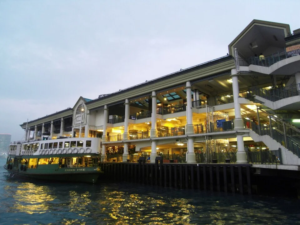
The relocated pier is shown here in a photograph made in 2012. A viewer encounters a lit building close to the level of the water, with the harbour in front. The image is good evidence for that particular appearance and position. It is not the view of a boat approaching the former Edinburgh Place landing. Keeping the date with it prevents an understandable confusion when older and newer pictures feature recognisably styled ferry facilities.
The operator describes the clock tower at the relocated landing as recreating a distinctive form associated with the service. The recognition has a purpose. A traveller can follow a familiar visual cue on a waterfront whose straight lines and accesses have changed. At the same time, an architectural reference should not cause a modern picture to be relabelled as the historic building. A form can be quoted at a new landing without bringing the old shoreline along with it.
Think of the relation between a service name and a stop. For a passenger booking or planning an onward trip, the familiar name gives a useful first answer. The exact location controls how far they have to walk and which turn they have to take. If a route guide silently substitutes one meaning for the other, it can appear accurate right until the person reaches the former destination. The name of the operator and the coordinates of the terminal are two distinct kinds of continuity.
Reading from the walkway rather than the ferry deck
A ferry route can be drawn across a chart as a connection between two banks. Add the approaches and it begins to look like part of a longer journey. Time between a train and a ferry can be spent walking, looking for an entrance and going through facilities contained within the pier. A move of the landing matters even when the water crossing still has the same endpoints at a district scale. Walking routes and connections can have reorganised by the time somebody reaches the quay.
The inverse happens when reading the shore from a boat. A person entering the harbour sees the new edge first. They may not know which buildings once stood nearer the water or which stretch of visible land was formed in a particular phase. An annotated view can mark a former edge by reference to an identifiable landmark without trying to make the modern photograph show water where there is none. The plan and view answer their own spatial questions.
There is no need for the archive to become a trip planner. An older photograph can record a building that is gone. A dated engineering diagram can show a line that existed between construction stages. For current travel, a person should consult the operator and current maps. The interesting work of comparison concerns why those two sources may direct the eye in different ways while using the same district name.
Mark the move without losing the previous place
One sign that the coastline was never only about ferry departures is the variety of landing places identified by number and purpose. The Civil Engineering and Development Department separately dates the public opening of Piers 9 and 10. They belong to the later Central waterfront alongside the ferry landing, but dates for public piers do not become dates for the Star Ferry service. On a map with several projecting structures, the functions and dates are useful additions. A row of identical pier symbols can document where the waterfront is and still conceal the reasons people go to different parts of it.
Public ground on the landward side matters to that choice as well. The same project record describes an advance promenade and later openings of adjoining open space. The promenade is a route along the shore; a ferry approach is a route to a particular point on it. For a walker they may meet, while a map prepared to show one may give the other very little attention. Trace a line along the water and a second one from City Hall toward the landing. Wherever those lines meet, the connection needs to work for people walking in different directions. Sketches that describe only the new extent of land do not make those movements visible. That is where photographs of the waterfront from the landward side could complement the view from the harbour.
A useful paired sketch puts one old shoreline and one later shoreline on the same scale. Add the old landing and the relocated one with distinct dates, not a single icon with arrows drawn both ways. Keep the landmark used to align the sketches. This makes it possible to discuss connections to the city without needing every building to be represented. It also keeps the fact of relocation from being swallowed by a more general claim that the harbour changed.
Return to the image of the new pier from the water. It shows something ordinary and something historically specific at the same moment. There is a place to step between land and boat. That place answers to the outline of the new waterfront. To find the earlier entrance to the same part of urban life, step away from the edge and open a differently dated map. The ferry gives the comparison a route; the shore gives it a history.
Further reading
- Hong Kong Civil Engineering and Development Department | Central Reclamation Phase III
- Hong Kong Development Bureau | Maps and facts for Central Reclamation Phase III
- Star Ferry | Company history and relocation of the Central landing
- Hong Kong Antiquities and Monuments Office | Hong Kong City Hall site plan