The Road to the Galibier Saddle
The pass road approaches a low point in a high ridge. Its bends, elevation and separate tunnel option explain why the shape of the crossing cannot be read from a straight line.
In this story 4 sections
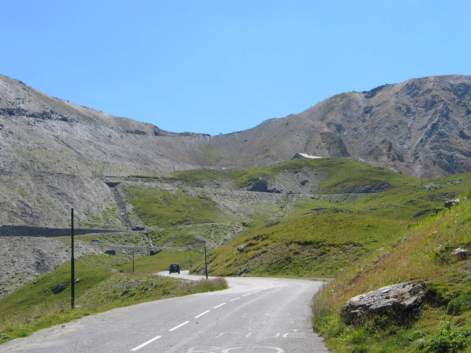
The distant road in Stephan Brunker's photograph makes no effort to look direct. It bends across a slope that rises towards the sky, then appears again on higher ground. A line drawn between its visible beginnings and endings would be shorter. It would also give little account of the work of gaining height. At the Col du Galibier in the French Alps, the shape of the route becomes a way to understand the shape of one piece of the mountains.
A pass is a place where a route can cross a ridge or associated high barrier. It can be a low point among the nearby heights and very high compared with either valley from which people approach it. The Valloire visitor organisation gives the Col du Galibier an elevation of 2,642 metres and describes links towards the Télégraphe to the north and the Lautaret to the south. The photograph looks towards the pass from the northern side; it neither shows the whole climb from Valloire nor every route the pass links.
Draw the ridge before drawing the road
On a sketch of the ridge, leave the road out to begin with. Mark two high points and the lower connection between them. From the immediate view along the ridge, that point is a dip. From a much lower valley, a route towards the same point is an ascent. The apparently opposite descriptions are measurements from different positions. An observer can draw the same shape on a profile and see why climbing very high did not always require seeking the highest nearby summit.
This is the sense in which the pass can be called a saddle. The term helps describe the ground around the location rather than the state of the surface or the condition of the road. As a comparison, a path along a ridge could descend briefly to the saddle before rising to another summit. A route crossing the ridge comes up the other slope and may descend on the other side. Those movements intersect at the same place but ask the ground to serve different directions.
A contour map can clarify the distinction. Look at how height changes across and along the ridge. Where the lines separate, a route can cover more horizontal distance between elevations than in a place where contours squeeze together. A road that turns need not gain the same amount of height during every segment. The contours describe the ground; an alignment drawing or a published route profile explains what the road actually does with it.
Distance and ascent do not report the same cost
The visitor organisation's specific profile beginning at Valloire lists seventeen kilometres and a gain of 1,212 metres to the pass. Dividing the gain by the published route distance gives a rough average proportion a little above seven percent. It describes the scale of the ascent over that named portion. It does not mean a person moving along it meets that gradient at every turn. Nor is it a calculation about a direct line from the town to the pass.
A hypothetical shorter road can gain the same height much more abruptly. A longer alignment can spread the required rise across a greater distance, although its local slopes can still vary depending on the ground. A turn can fit more road on the side of a mountain without making the route artificially flat. That is one reason the little length of road visible in the photograph would be a poor basis for guessing what the next section requires. Each visible bend belongs to a larger sequence of gains and changes of direction.
The question also depends on which way someone goes. A profile that helps explain a climb gives another reader a descent when read in reverse. What remains constant is the relative height of its named points. Sight lines, effort and practical conditions change with direction and actual circumstances. This geographic comparison does not give travel instructions. The appropriate road information for a journey is a separate, current source.
A tunnel and a pass can be related without being identical
The Hautes-Alpes landscape material describes a tunnel at the Galibier. Valloire gives a history of its closure in 1976 and reopening in 2002. A tunnel makes a crossing through the ridge possible at a different position from an exposed path reaching the high point of the surface route. A diagram should mark the portals and the surface meeting point separately. A person looking only at an overhead line may otherwise see two alternatives as a single dot.
On the photograph's source page, the uploader identifies the northern approach and describes the place of a tunnel relative to landmarks in the view. That is helpful for orienting the picture. It does not identify whether a particular route is open at a later date. Historic dates for the tunnel say something about the infrastructure's life; official status says what is possible at a given time. It is reasonable for a history of the pass and a journey planner to display different kinds of information.
The relation between the two possible lines illustrates why place names need a little space. Galibier can refer to the mountain crossing, the general area, the high point of a route or the tunnel among more specific uses. An altitude attached to a pass sign should not be copied to a tunnel portal without checking the measurement. The name is useful for recognising the area and not enough to locate every part of it precisely.
Valloire dates the start of road construction to 1879 and the completion of the tunnel to 1891. Its description puts the tunnel at about 2,556 metres and gives the surface pass a different elevation. That provides a rare chance to compare two figures printed for the same general mountain crossing without treating one as an error. Each belongs to a position. An editor drawing a diagram could use the approximate difference between them to put the alternatives in scale, while leaving the precise portal locations and dimensions to an appropriate survey.
This separation helps with historic views of use. Reconciling a travel account that describes passing through the ridge below the saddle with a later picture of a road rising to the top requires more than comparing names. Ask which routes were in operation when the account was written. The route that carried earlier traffic may not match the one chosen by the photographer. The documented closure and reopening make dates part of any explanation of why two accounts of the crossing describe different sights at their highest point.
A landscape photograph can show the problem, even when it hides the solution
The road visible from the north can seem to approach its destination several times. The next bend reveals that one upward line belonged to an intermediate position. A photo makes some of the bends easy to see and leaves others hidden by ground. If the route seems interrupted where a slope blocks the lens's view, that is a reason to compare the picture with a plan. The apparent cut-off can belong to the camera angle while the road itself continues.
The mountains also provide a scale the road does not supply by itself. A winding line long enough to be a significant journey can appear small beside a continuous high slope. Trying to judge its gradient from a tilted image can be misleading. Knowing where the camera stood, where the pass lies and what portion of the road appears makes the comparison better. Use the aerial or contour view to recover directions and the profile to recover changes of height along the named route.
There is a further distinction between climbing to a place and looking out from it. The photograph looks at the northern approach with the road as one visible object. The visitor organisation also names views of surrounding mountains from the pass. A view outward can reveal the relation of one ridge to another and give less information about the bends already travelled. To compare an approach photograph with a view from the saddle, mark the location and direction for both. A skyline visible from one place need not be a direct continuation of the skyline in the other image.
The seasonal information on departmental road services belongs to another layer entirely. A line can be present in an engineering drawing each day of the year without being open for use each day. A historic opening date or one old summer photograph does not settle that condition. Separating the stable parts of a map from operating information makes the map more useful as geography and less likely to be mistaken for current travel clearance.
Label a view with the year as well as the place. The 2005 cover is an observation of the approach as it looked then, after the tunnel reopening described by Valloire.
In that comparison the saddle provides a destination only for the crossing of the ridge. A route continues away from it. The parts on either side are connected even though a picture commonly stops at the celebrated top. Give the journey both beginnings, with published references for the named valleys or places. It becomes possible to see why a bend approaching a relatively low notch can belong to a very high road. The contours around the notch make that apparent contradiction the most informative feature in the photograph.