What the Old Bridge at Mostar Connects
Mostar’s stone arch crosses the Neretva, but its two approaches explain why the crossing matters to a wider patch of the city. The reconstructed bridge links a place as well as two banks.
In this story 5 sections
From the river the old crossing at Mostar looks like a single stroke: a pale stone arch with buildings gathered close to both ends. Turn to a map and the stroke shrinks. Short streets and paths take up most of the work of getting to it. The bridge is quite small compared with the valley, but its position helps explain the concentration of activity around it. If all you measure is how far one bank is from the other, there is little reason to notice the streets beyond the towers. Those streets are part of the crossing.
The Neretva runs through a deep valley in this part of Bosnia and Herzegovina. In the Old Town, an approach to the river can mean a change of height as well as direction. The places where a route can get above the water and at the same time meet paths on either side are limited by more than the width of the current. The high arch at Mostar makes that negotiation legible in a single view. Walking toward it, you meet the town as a succession of smaller decisions.
The bridge on a line drawing
Imagine tracing the river and the bridge in pencil, without any buildings. You can show the two banks and the shortest line that joins a pair of points, but there is still no answer to how someone gets to those points. A market route could arrive on a bend. The next street might stand above the riverbank rather than beside it. Paths can share a short piece of approach and then split toward entirely different places. Adding the street network to the drawing turns one crossing line into a choice made over and over.
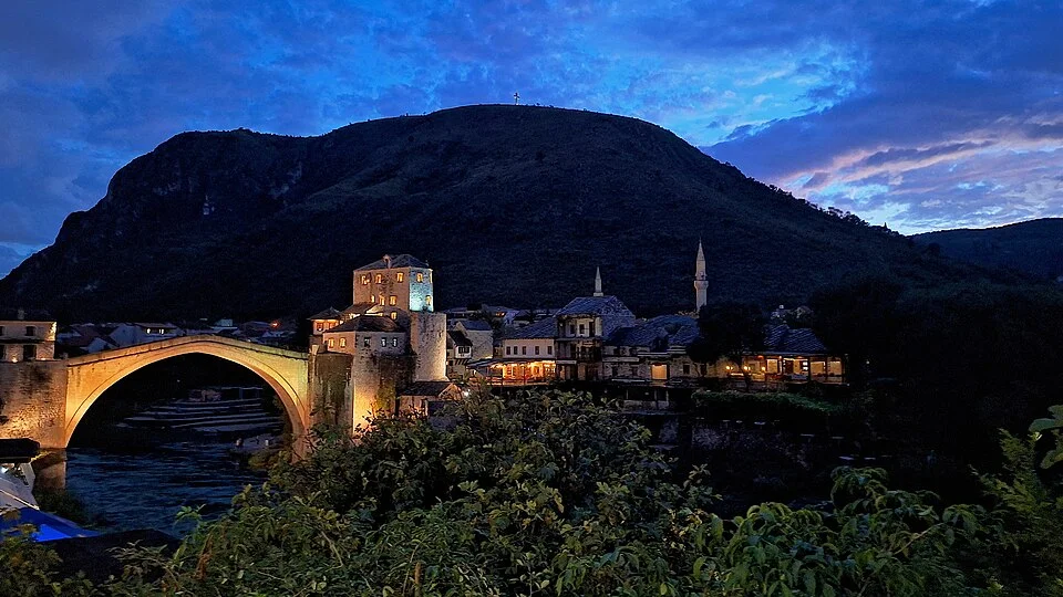
This is why a photograph taken squarely across the river can leave such a different impression from a walk on either side. The photo gives the arch a silhouette and places the towers where you can see both at once. The walker meets one end first and may see the route after it only near the crest. Neither record is wrong. Use the river view to understand the rise and span, then look at a map of the old streets to understand why the crossing appears where it does.
UNESCO describes archaeological evidence for earlier medieval crossings close to the site of the later Old Bridge. That supports a history of a useful crossing location rather than one isolated decision to put an impressive arch on an empty reach of river. A new structure can carry an old route. The drawing of the route need not stay identical for centuries for a location to remain useful. Even the discovery of previous bridge remains nearby says little on its own about which street a particular traveller chose.
What you meet before the crest
The Ottoman bridge was completed in 1566 by Mimar Hajruddin, whom UNESCO identifies as a pupil of Sinan. The source describes an arch opening of about twenty seven metres. To a person reading a plan, that is a fairly short distance. From below, the height is the more insistent measurement. The arch has to meet its supports while leaving the river underneath; the top of the crossing rises from each end. From above, those numbers turn into an approach, a crest and a descent.
Halebija and Tara, the towers that flank the bridge, give both ends a built threshold. In a view made from downstream the arch can seem to touch the buildings. On foot the relevant sequence is different: street, approach, entry to the crossing, a stretch of open air, and a return to the buildings. Those moments matter because the shortest strip of the journey is also the one with the least freedom to turn aside. The decisions are concentrated immediately outside it.
A route drawing can mark these features with small symbols, but a note about the surface and slope makes it more useful to someone planning a way through. A steep crest, uneven paving, a crowd or a place where the onward path is difficult to see can matter more than the numerical length of the structure. This is a general lesson about reading an old street map, not an assessment that one bridge is the right crossing for every visitor. A map that records several ways across or around a place describes a city better than one that keeps only the famous line.
The part that is remembered and the part that was built again
The sixteenth-century bridge was destroyed in 1993 during the war in Bosnia and Herzegovina. The arch that visitors see today was rebuilt and reopened in 2004, with a wide reconstruction effort around it. Calling it the Old Bridge preserves the historical name for the crossing. Calling it the reconstructed Old Bridge records the major change in the fabric. A caption that gives only one date is likely to make someone choose between those two truths when the place requires both.
UNESCO describes international support for the project and expert involvement in rebuilding the bridge and restoring parts of the city. A reconstruction that aims to recover a known shape is not the same assignment as the first designer's work. The location was already charged with meanings that the reopening could not single-handedly settle. A continuous route was one concrete thing the project could restore. The return of an arch to the city's profile was another. Neither should be offered as measurement of how individuals on either bank thought about what had happened.
Photos can help keep the dates straight. A view made before 1993, a view while there is no stone span, and a view since 2004 record different conditions. Looking at a group of undated pictures, it may be tempting to treat all uses of the name as pictures of one unaltered object. Keep the date and vantage point with each photo. The twilight cover used here, taken in 2023, belongs firmly to the rebuilt period. It supplies an answer about how the current span and the river appeared together at that moment, not about the look of every old stone on the predecessor.
A World Heritage area with streets attached
The protected property is the Old Bridge Area of the Old City of Mostar. The name is longer than the bridge's name for a reason. UNESCO's description includes the built approaches, houses, places of worship, areas of commerce and archaeological layers as part of the significance of the place. Several architectural traditions appear in its description of the wider settlement. Leaving all that off a map would make the bridge easier to find and harder to understand.
Think of the difference between a plan of one building and a map of its neighbourhood. The first tells you where to go inside. The second shows how a place adjoins other places and what journeys can pass through it. Around Stari Most, that might mean drawing the relationship between the bridge approaches and nearby streets, not merely shading a point on each bank. A walk that approaches from a wider street will have a different rhythm from one that turns into the route at the last moment. In both cases the small span is one part of the city available to the walker.
That also changes the question about preservation. Keeping an arch intact does not keep every approach intact automatically. The arrival of a new sign, an altered walking surface or a change in the function of a nearby building might leave the view from the river recognisable while changing the experience at the bridgehead. The reverse can happen as well: a street can continue to carry familiar journeys through a recognisably historic district even when some fabric has been rebuilt. The visual record and the route are related, but one cannot take the other's place.
Make a second map after the postcard
A useful exercise is to draw two versions of the crossing from published maps. Give the first the river, the outline of the arch and the towers. In the second, omit the outline of the arch and keep a simple line between the banks. Spend the spare room on what links to that line: the immediate changes of direction, other possible connections, the point where the streets grow narrow, and the extent of the historic area. Treat slopes or steps as information to check rather than shapes you can guess from a thin line on a map.
If the two drawings tell different stories, they are doing their jobs. The first explains why the bridge can stand for the city in a photograph. The second makes clear why a place where people cross has to be connected to places people want to go. One view gives the valley a mark. The other follows the routes that draw it.
The name Stari Most has often travelled farther than a drawing of Mostar's streets. That is understandable: the curve of the arch is easier to remember than a series of turns going down to the Neretva. But the crossing has two ends. Its history, from the earlier bridges to the built work of 2004, makes more sense if we give as much attention to the ground at either end as we do to the stone in the air.