The Islets Under the Atlantic Road
A famous arch is only one part of Norway’s Atlanterhavsvegen. Read the chain of small landings and water gaps to see why the road makes such a variable journey.
In this story 4 sections
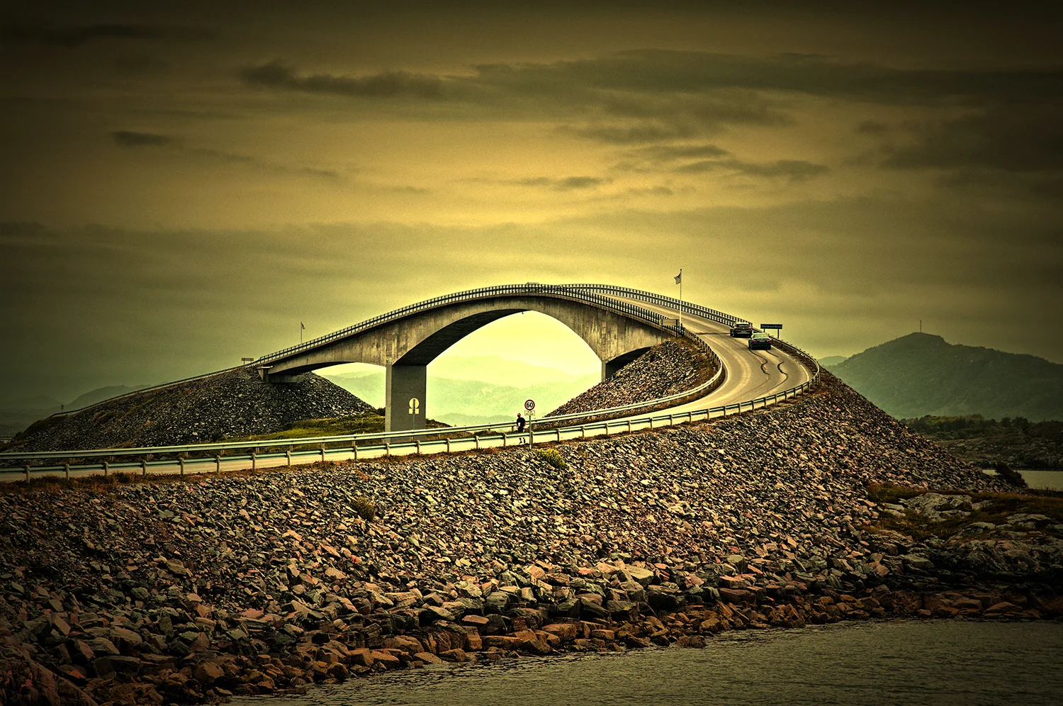
From one view of Storseisundet Bridge, the road at the crest appears to rise almost apart from everything else. Where it lands can be much less conspicuous. The photograph shows one crossing on Norway's Atlantic Road, or Atlanterhavsvegen. To read the route across water, find the little pieces of coast and island on which the road can land. They explain why several crossings appear in succession and why moving along the route can look different from making a single leap across an inlet.
The Norwegian scenic routes agency describes the road running among islets and reefs along the exposed coast at Hustadvika. Its mapped scenic itinerary extends between Kårvåg and Bud and includes other kinds of coastal setting beyond the bridges. The crossing in the image is a useful starting point precisely because it is smaller than the full journey. It makes the adjacency of land and water obvious. The map makes it possible to see what joins that moment to the next.
Plan the landings before connecting the gaps
On a plain map, shade the nearby land without marking the route. Some islands are close while others have strips of water separating them. The apparent distance across the whole area says only a little about where a continuous road could be built. The useful points for a connection include places where a road can approach, where a crossing can reach a suitable landing and what direction the following segment needs to take. An islet can be too small to dominate a regional image and still matter very much to how the chain is organised.
One bridge could appear to cover a longer distance than its neighbours simply because the land around it is spaced differently. The height, curve and visible length of a bridge can also create striking photographs. None of those observations tells the full story of route selection on its own. A view from offshore gives a broad outline. Section and alignment drawings could show how the across-water span and the ground on either end meet. Generalising from a picture is most reliable where the picture can be linked to a named crossing.
Short connections on land still count. They are where a traveller reaches a new approach, changes direction and can move from a broad view back towards a narrower channel. They can also give a person a much clearer sense of having crossed than the centre of a bridge does. The road itself may read as continuous from a vehicle. Its construction and landscape depend on passing through alternately supported and open spaces. A map is useful because it shows the distinction in one colour change beneath a continuous route line.
A bridge has a profile as well as a path
Look at a plan of the bridge and then at the photograph. The line seen from above can show a curve and where it begins to turn. The photograph made at a lower level can emphasise the height. A road seen obliquely can seem to run out at the skyline because the next part slopes away from the camera. This is an optical effect produced by the crest and the viewpoint. It is not evidence that the roadway stops there. The approach and descent can be perfectly continuous even when only a narrow part of one is visible.
That is a useful comparison for any landscape in which a route changes direction and height at once. If the line bends to one side, a view from its inside and outside will not show equal lengths. If it rises, a high viewpoint can preserve connections hidden from a low one. A reader can use a picture to locate the main feature and a plan to follow its direction. They need both positions named before explaining a dramatic-looking profile as if it were visible from every approach.
A route map also helps to distinguish a bridge from the whole section to which it belongs. The famous image can circulate under a title that names the Atlantic Road without giving the local bridge name. Someone planning research can recover other views by identifying Storseisundet specifically. Somebody following the scenic itinerary can ask whether a named rest area is at the bridge or elsewhere. Those small geographic differences soon have a practical effect on the rest of the journey.
Weather and observation change around a fixed road
The scenic route page calls attention to the exposure of the bridges, including strong winds as a consideration for cyclists. The relevant conditions for actual travel need current official information. A sunny picture of the concrete tells us neither the wind on the day of a proposed visit nor the form of access then available. What the image can show is the closeness of open water, the way a crossing stands in that setting and the limited amount of land between particular portions of it.
From close to the water a modest rock can occupy a great deal of the view. From higher up the same rock can provide a permanent point between sea and sky. Near the shore the direction of waves and the appearance of the water can change without affecting the road's plan. A photographer choosing the most dramatic moment can demonstrate the range of appearances without documenting an average condition. A person interpreting the place should keep conditions and composition attached to the date and position of the image.
Rest areas and viewpoints provide another sort of connection between engineering and landscape. The official route map names several. They matter to an account of the journey because the line someone travels along and the place from which they can stop and look need not be the same. Pictures made from a shore or viewpoint can describe structure unobstructed by the experience of travelling across it. They also give a traveller a way to consider how the road reaches ground instead of focusing only on the horizon.
The road consists of more than its most useful emblem
The bridge in the photograph by Lars-bh can be read against a curved approach and a prominent rock slope. That foreground is worth keeping. If the image were cropped close to the crest, the bridge might look suspended between forms whose positions could not be inferred. With the surrounding ground visible, the approach has a beginning. A reader can recover the fall away on the far side from a plan rather than filling it in by extending what the road does near the camera. This makes the photo useful for noticing one half of a relationship and useful enough to show why another source remains necessary.
Compare a trip across one short stretch of road with the same distance driven in a straight line. If one route bends to meet solid ground, its direction can change several times in a modest distance. The distance may still be more convenient than a broad detour around open water. A plan of the chain helps distinguish the shape of the journey from its justification. The local ground provides possible landing sites. Designs and construction records would be needed to show what the actual builders rejected or why a specific structure was chosen.
Printed route guidance can also make different choices about the scale of the coast. A larger overview can show where the scenic road sits in relation to alongshore journeys. A detailed inset can make clear which stretches are on islets and which are on spans or embankments. Without both, a viewer can either understand the geography in broad terms and miss the bridge approaches, or recognise the bend in a highly photographed bridge while having little idea how it connects to the rest. A photograph inviting attention to one distinctive rise is a good first view. It is far more useful when the next figure is free to ask a different question.
There is a difference between using a photograph to recognise a route and using it to explain what happens on the route. An arch works well for recognition. A chain needs several landmarks and a clear account of the ends. A useful map might mark the named bridge, nearby landings and the shore visible within one photograph, then extend the frame to the remaining official itinerary. The change of scale allows the arch and the longer route to keep their meanings.
A similar principle applies to names. A short segment between islets can be what a person intends when saying the Atlantic Road, while the official scenic itinerary follows a longer path through more coastal settlements and settings. Read the entity described by a length or label before comparing it with another description. Differences can arise from the endpoints rather than from bad measurement. Here that distinction helps explain why more ground belongs to the published journey than one photograph of a bridge can reasonably describe.
Give the islets a place on the diagram and the ocean crossing acquires rhythm. Open water has not disappeared. It is crossed, reached again, viewed at another angle and left in the space between landings. The bridge in the picture is a strong mark of one such change. The land beneath and beyond it explains what makes the mark part of a route.