What Makes Peyto Lake Blue
Peyto Lake’s turquoise is a property of light and suspended mineral particles, viewed across a whole valley. The shore and the water are easier to understand if the colour is treated as evidence with limits.
In this story 5 sections
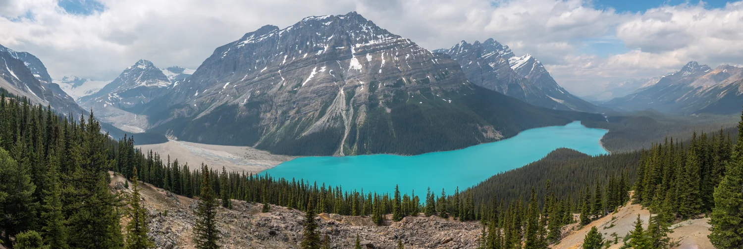
Peyto Lake takes up a narrow strip of Ethan Sahagun's broad photograph from Bow Summit. There are trees almost at the viewer's feet and higher slopes across the valley. In the middle is a colour that does not behave like a patch of blue sky dropped into the picture. A cloudy part of the sky and its brighter surroundings remain visibly different from the turquoise surface below them. Changing the relative amount of sky and lake in the frame would alter the composition. It would not tell us how the colour arose.
Parks Canada singles out the turquoise view of Peyto Lake along the Icefields Parkway in Banff National Park. The U.S. Geological Survey discusses Peyto and Lake Louise in explaining how finely ground material carried from glaciers can change the colour of water. That is a better starting point than attributing everything visible from a high lookout to a reflection. A photograph shows what light reached one camera. The ground and water suggest what could have happened to that light on the way.
A glacier can produce particles small enough to travel
A glacier is not a motionless white cover laid over a valley. As ice moves with rock and debris beneath and within it, it can abrade rock. The result includes very small particles, among them clay-sized and silt-sized material. The USGS uses the term glacial flour for the fine debris that can be washed into lakes. The word makes sense seen against the scale of a whole boulder, especially for someone used to thinking of erosion as large pieces broken away.
Once transported by meltwater, finer material can remain suspended for a time and be carried away from the point where the water enters a lake. It is still material in the water, not a blue dye dissolved to a uniform strength. The size of particles affects how long they remain in motion and how they interact with light. Different amounts of sediment could be brought in at different times, mixed through part of the lake or deposited. The processes depend on conditions. Nothing in a broad photograph supplies a direct grain count.
The catchment beyond the frame therefore belongs to the explanation. If a valley slope or ice field supplies material to moving water, the lake is part of the route the material can take. You do not have to see the site where each grain was made in a photo of the lake to ask about that route. A map of water connections and a record of surrounding geology can help carry the story beyond the lake's visible boundaries.
What a particle does to a view
Light reaching the water can be reflected at the surface, pass into the water and be absorbed or scattered. Suspended particles can change the light that reaches a viewer. The USGS describes the fine glacial material in lakes such as Peyto as one reason for the milky blue appearance. There is no need to suppose that individual grains visible to the naked eye have exactly the colour seen in the valley. The colour depends on how light interacts with an enormous number of small particles and the water that holds them.
Photographs of the same lake can differ without either having replaced the water. The angle between the viewer, surface and sunlight affects reflections. A cloud can change illumination over the valley. The amount of light reaching the camera and its processing can shift the recorded colour. Sediment supply and distribution can change too, but to attribute one picture's greater brightness to additional flour requires evidence about those other conditions. A picture dated and located is valuable. It is a poor substitute for a controlled comparison of light and water.
Water has an optical history of its own even without a high load of fine particles. Light does not pass through it with all colours affected equally. Adding particle scattering alters the result, together with the depth viewed and what lies behind or beneath the water. There is room for reflection and suspension to matter in the same image. One becomes an unsatisfactory answer only when it is invoked to explain every shade on the surface by itself.
The useful scale begins above the shore
The photograph looks down on the lake. From that vantage point the visible patch can be compared with the trees, grey slopes and clouds all at once. At the shore the view would include a nearer area of water with different reflections and a shorter or longer path through the surface depending on the angle. A shallow edge can show a bottom that a person cannot see through deeper water. Neither vantage point is inherently a more truthful view. Each is good for making a different kind of observation.
Compare two stretches of water in the photograph in terms of the shapes behind them. One may sit below an illuminated opening in the clouds and another in partial shade. Some differences might track the landscape and surface angle, while others might trace movement of water. A record of positions and appearance at the same moment can help formulate questions to check. It cannot by itself determine whether one stretch held more sediment if everything else also differed.
Scale also matters if maps are used to connect the valley to its upstream sources. A small tourist map may correctly put Peyto Lake beside the route to its viewpoint. It may not draw every contributing stream or show which direction water travels around a bend. A catchment map can carry more of that information. A profile can show the difference in height between the lookout and the shore. The famous photograph is one part of the geography, rather than the map whose omissions must all be supplied by imagination.
Two lakes are not a controlled comparison
The USGS names Lake Louise as another example where very fine glacial particles affect the colour. That is a reason to compare the type of process rather than presume the two lakes should always look the same. Depth, the angle of view, suspended material and the immediate light conditions are not fixed just because one national park contains both. A pair of photos chosen for striking colour can illustrate a shared mechanism without measuring a difference between them.
A better comparison for a specific question would involve observations with identified times and positions, and records of the conditions affecting the water. To investigate the role of suspended sediment rather than simple visual resemblance, one would need repeated measurements or samples designed for the question. A viewer without access to those can still name the plausible mechanism supplied by the survey. They should leave a difference in colour as an observation, not translate it immediately into a number of particles.
One can see why the analogy with flour is useful and where it ends. Flour swirling through water at home can help someone imagine a previously clear liquid with material in suspension. It does not give a realistic sample of the minerals, particle sizes, circulation or light at Peyto Lake. The geological term is a clue to how extraordinarily fine the debris can be. It is not a colour formula.
A foreground and a catchment can belong to the same story
It is tempting to equate bluer water with clearer water because both can seem bright in a photograph. The USGS's description of a milky blue lake is a useful counterexample. Material in suspension can alter the light returning toward an observer while making it harder to see through a long path in the water. A report on visibility into the water and a record of reflected colour do not have to tell the same story. If a study asks how clearly an object is visible beneath the surface, a hillside photograph will have something much less direct to say about it.
A map comparison can likewise distinguish a source from the place where its effects are seen. A stream carrying sediment will have a location at which it enters the lake; much of the lake photographed from the lookout lies away from any one point of entry. A patch of colour on the far side is not sufficient evidence for another inlet, and an inflow off the picture is not absent from the watershed. That difference keeps the geography connected to the optical question without asking colour to serve as a complete map.
Parks Canada presents the viewpoint as a way to see the lake from high ground. The panorama makes the most of that position, keeping mountain and trees in the frame while the lake takes one bright shape below. The broken foreground gives the eye a mark of where the person taking it stood. It also makes a useful connection back to stone. Ground that can hold a person and particles small enough to affect light are radically different evidence of the same broad kind of material.
There is a good geographic question to take away from the colour. Ask what route right-sized particles could have followed from the surrounding rock to the visible lake, then ask how the viewing conditions make their effect apparent. The first question belongs to ice and water moving through a valley. The second belongs to light entering, changing and reaching the viewer. From Bow Summit both histories can occupy the same blue shape. The photograph makes their meeting visible without reducing one history to the other.