The Channel Along a Wadden Sea Flat
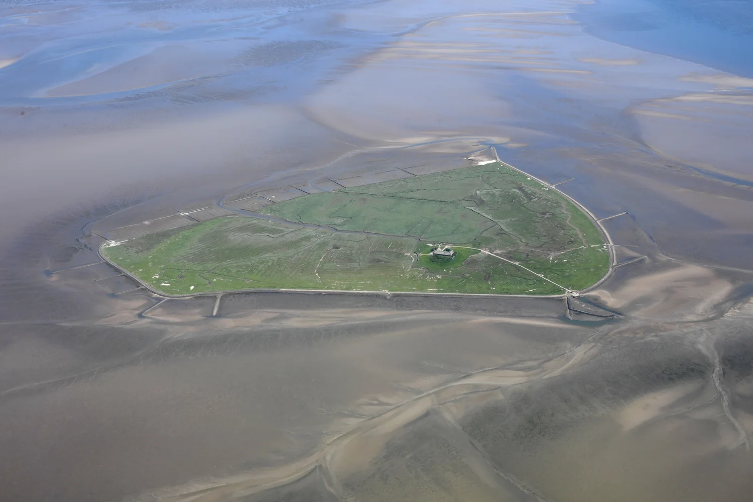
An aerial view of Hallig Süderoog shows water in some channels while nearby flats are exposed. Height, tide and moving sediment explain why the lower lines remain visible.
In this story 6 sections
The green island in Carsten Steger’s aerial photograph stands out among much broader shades of brown and blue. Around it are low flats and twisting lines. Where light catches the broader stretches, it is hard to know by sight alone whether there is a shallow cover of water or simply a wet surface. Other paths remain distinctly watery for much of their length. The picture shows Hallig Süderoog in the German Wadden Sea. Its file description places the exposure about two hours after low water. That detail is useful because the picture is showing a relation among the ground, the channel and the sea at one point in a regular change.
The Wadden Sea extends along shores of the Netherlands, Germany and Denmark. The World Heritage description emphasizes the large zone between levels reached by ordinary tides. At a suitable height some material can be uncovered when water retreats and covered again when it returns. The channels in the picture give a way to read that process. They are part of the paths water can use while the exposed area changes. Track one line in the photo, and it becomes possible to think about the work of the tide not just over a broad surface but at a particular depth.
Put the flat and the channel into one section
A profile across a flat does not have to show a deep valley to reveal where water will stay longer. A low path can remain available after water has left the adjacent surface. As water levels change, more or less of that profile is covered. Part of the flat may become exposed and still be damp; part of the channel may still contain a flow. Imagine trying to describe both in a single word such as dry. The differences that matter to the water have not disappeared simply because a broad piece of ground is now visible.
It may be easier to picture a broad shallow basin behind offshore barrier islands, with openings connecting it to water outside. Water moving in and out has to use the routes that the land and seabed leave available. Its effect at one point is related to a wider area of water that is exchanging through those passages. The Wadden Sea Quality Status Report distinguishes tidal flats and basins behind barriers and discusses their changing sediments and shapes. The edge of a flat is not a wall holding the same water in the same position. It is a place where water can move across different areas as height and flow change.
One reason aerial views are valuable is that small differences in level are hard to appreciate from the ground. A long curve connecting two pools may make more sense when seen as part of a branching route. The picture is not a survey of the depth of that route. It shows how the lower material lies relative to the green land and to other broad parts of the flat. To find actual height or depth, a viewer needs another kind of evidence.
A picture at a different tide can be of the same ground
Steger also photographed Hallig Süderoog near high water. The comparison is useful even if the camera angle and exact lighting differ. The green form is still recognizable, but a much greater share of the surrounding space can read as water. An observer trying to locate the channel at the best moment for a dry-looking aerial diagram might prefer the low view. An observer asking how much of the area can be covered would want the other view as well. The point is not to demand that one be called the correct picture. Each retains a condition the other omits.
Nor do high and low water occur simultaneously across a long, irregular coast in the way arrows might suggest on a simplified map. An interval specified for one site has to be related to that site. Wind and other conditions can also affect water levels. A date and tidal description make a photograph a more useful observation, but they don't make its margin a general chart of everywhere a person will encounter water. It helps to ask which portion of the surface is visible, why it was visible then and what evidence says how the position changes.
This distinction becomes visible around the island’s outline. Some features such as a built edge or a piece of higher land remain recognizable over both pictures. The line where water happens to meet a shallow area can move much farther across the image. A good comparison puts those relatively durable references and the moving edge on the same plan, while keeping separate the questions they answer.
A channel both moves water and feels its effects
The flow of water can transport sediment. Some material can settle on shallows where movement allows it; elsewhere a stronger current can carry material on. Grain size, the direction of flow, waves and the condition of the surface all matter. A tidal channel can retain a recognizable curve and still alter over time. The alternating movement at different parts of a tide does not imply that every grain of sand or mud is put back where it started at the end of the day.
One can compare two imaginary parts of a basin. In one, a narrow flow has a fairly clear route for moving between higher surfaces. In another, the route spreads into shallower ground and becomes difficult to see as a single line. The transport experienced in those areas need not match because the same rise in sea level reached both. Shallow surfaces can also be disturbed by waves under conditions different from those in a sheltered channel. It makes sense to speak of a connected system of sediments whose local workings can differ.
Notice how this complicates an explanation based on only one photograph. A pale strip that appears at low water can show material at the surface, not how many times it was moved or deposited. A line that grows darker as one reads along it could correspond to depth, wetness or differences in light. A second view taken after an interval can show where an outline persisted. Measurements of ground level, water and sediment then help explain how it came to occupy that position. The combination is more informative than making the photograph answer the whole sediment problem.
A stretch uncovered for part of a day still belongs to the sea
The term intertidal refers to a position between recurring levels of water. It does not say that the land in it belongs to two unrelated landscapes. The shape of a flat affects what water does on its way across, and the movement of water helps maintain or change the flat. Conditions that affect plants and animals can change between times of exposure and submergence. Someone reading a landscape view can start with this physical relation before attempting to identify which features are occupied by different kinds of life. At that scale a broad apparently vacant surface can be a place undergoing several important changes.
It is helpful to place this ordinary repeated motion beside gradual changes in the larger landforms. An area may be revealed each day without remaining the same shape over decades. A channel may shift without changing the fact that a tide reaches into the basin. Keeping the two kinds of change in view helps someone avoid mistaking new exposure for new land, or a partly different channel for a change in the identity of the larger area.
Look for a change that survives the tide
Measurements made over many tides answer a question the two pictures cannot settle. Suppose an observer wants to know whether the outer margin of a channel is migrating. A dark ribbon from a high stage cannot simply be compared with the dry lip in a later low stage. The features that produce the two marks are different. One might be the edge of water over an already submerged bank; the other might be a break in slope on exposed sediment. To compare positions, start by choosing a feature that can be identified on both dates and bring observations into the same reference frame.
Height data would permit another sort of comparison. At a fixed line across the channel, look for movement of the deepest part or a measurable change in the slope of a bank. At a fixed point away from that line, an observation of water level still answers a useful question: how often that point is covered. Track the two measures separately. An ebb can move an edge several field widths over a few hours without moving the ground underneath it very far at all.
Keep the channel in the picture
In the lower side of the photograph a branch lies beside land exposed around Hallig Süderoog. Look outward from it and more of the wide surface comes into view. The branch offers one line through the larger shallows. Draw another line across that one to connect ground at different heights. Now the photograph begins to show how the space changes its use as water arrives and departs, without suggesting that one tide is the same as every other event.
From farther back the green island remains the strongest shape. Close attention to what surrounds it can be more revealing. A patch of grey or brown beside blue is evidence of a moving boundary. The channel is a way to understand that boundary even at times when a film of water could hide it again.