The River That Ends in the Okavango
A flood spreading across Botswana can owe its timing to rain far upstream. In the Okavango Delta the water expands through inland channels and shallows without finding a river mouth at the sea.
In this story 6 sections
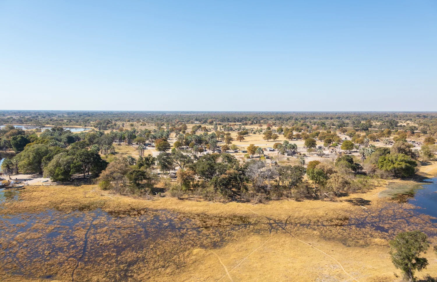
There is a relatively dark stretch of water at the bottom of Diego Delso’s photograph of the Okavango Delta. Above it are yellow vegetation, uneven openings and stands of trees. Water reappears toward the right. Beyond lies flat countryside with very little height to distinguish one horizon from another. Seen from a little higher, the narrow divisions would become a recognizable system of waterways and patches of ground. What the view does not supply is a final shoreline where all the channels meet the ocean. The delta sits inland, in Botswana.
A river can come to the last part of its journey without entering the sea. In the Okavango, water arriving at the low country spreads through a broad network whose extent changes over the year. Much of the supply begins with rainfall far from the delta, in the upstream basin that includes high ground in Angola. By the time the flood has reached one part of the delta, the timing of rain near it may be a very different story. Learn to read the changing outline of water and it becomes possible to see why a place that looks very dry from one position can be part of a substantial wetland at the same time.
A river can end without one final line
The word delta often brings to mind the deposit built where a river enters a sea. Many deltas do occupy that setting. The Okavango is an inland delta; UNESCO describes it as a large system without an ocean outlet. Once in the broad basin land, water moves into channels, flooded areas and other low ground. Its journey can be spread over so much space that there is no single shoreline whose location always describes the end. Water can disappear from view into the ground, return to the air or continue through a narrower drainage route under particular conditions. None requires the opening at the coast found in the familiar example.
The distinction affects how one follows the river on a map. Looking from its upstream course, an incoming flow can be drawn as a line in a reach well enough defined by banks. Farther through the wetland, the area it reaches is itself important. A map with one consistently thick blue mark running from top to bottom can conceal both the widening and gaps between wetted areas. Maps of different dates may disagree about those edges without one being poorly made. The boundaries depend on how much water was present, how it had moved through the terrain and when the traveler or instrument recorded it.
Imagine drawing over an aerial photo with a fine pen. Some narrow, dark lines seem obvious candidates for channels. Other dark patches may be shade, muddy water or wet ground. A wider view can help tell which ones connect to an apparent path. It cannot settle how long those connections stay open or whether a flow in one branch actually joined another on the date of the picture. The exercise is useful because new questions appear when the obvious lines disappear.
The season upstream is part of the delta's calendar
Rain can contribute to water that gets into the wetland directly. A substantial seasonal inflow also travels from the wider basin. The far side of a river system makes a difference here; a pulse that begins upstream needs time to reach Botswana and spread after it arrives. NASA’s account describes this timing as a reason flooding can reach the delta during the local dry season. Take two locations, one in the catchment where rain is feeding the river and one in the wetland where levels are responding to earlier inflow. Their seasonal accounts may sound out of step because they are describing different parts of one route.
The difference is practical. Seeing rain today at the delta does not tell a person what volume is moving toward it from far upstream. An area of water covering much ground today could reflect an earlier event in another place. By the same logic, a relatively quiet period immediately after rain in the upper basin does not imply there will be no effect farther along. It is useful to think of the flood as an arrival that can move across great distances and spread over places that respond at different times.
An official account of basin flows gives a better outline than the idea that all of the delta is at its wettest at one moment. First a change arrives at a part connected to the main supply. A patch farther from the most direct passage can fill later, to a different extent or perhaps not during a smaller event. A calendar label for a whole region is a guide to those changes, rather than a promise about the conditions of any one photographed channel.
The size of a water surface affects what happens next
On relatively flat ground, water can spread a long way with little change of height. A broad spread means a great area of surface where water can return to the air, directly or through plants. Ground can take up some of the water as well. The importance of these paths becomes clearer when the system isn't assumed to need a river mouth. Think of a substantial flow arriving in one confined channel and spreading into a succession of shallows. Some of that water can move onward without most of it having to gather back into one equally substantial outlet.
What makes this change hard to see is that some paths out do not look like moving water from a distance. Evaporation leaves no narrow blue line leading away. Water moving below the surface can't be followed from the aerial image. A changing plant cover can indicate which areas often receive water but need not outline the shape of an older flood exactly. It is worth keeping a question about where visible water goes separate from a question about where all of the water in the system goes. The latter requires a wider account than any particular photograph can supply.
Consider another imagined cross section of shallow ground where a little difference in elevation changes which sites still have water. One channel can retain a narrow route after a broad adjacent patch dries. A depression nearby can hold a pool that no longer looks connected. The next flood can join those parts again. The changing outline says a great deal about how often they participate in the wider wetland. A label that calls both of them wet doesn't necessarily capture the difference between an enduring channel and a patch newly reached.
Draw the dry ground as carefully as the channels
The picture contains plenty of vegetation and ground not visibly covered by water. Those areas belong to the landscape of the delta as much as the dark band at the bottom. The local heights that make them dry also give water a way to pass alongside them rather than spreading evenly across everything. The visible trees help locate some of the more established patches. They should not be treated as permanently dry simply because the picture shows them apart from open water on one occasion.
That relation makes the delta interesting to map over time. One set of observations might distinguish channels usually visible from intermittent shallows. Another might describe changes in the route of a branch or the local accumulation of sediment. Change in the shape of the ground and change in the area covered by water can occur together. Watching only the furthest line of one flood can obscure the terrain that guided it. Watching only the shape of a ridge can leave a person unable to say which part of a water year the view represents.
Compare the inlet with a field of changing outlines
A river gauge at the entry to a broad wetland measures something different from a map of the area currently covered by water. The gauge can describe arriving flow at a point. A map obtained by separate observations can describe what became wet across a much larger area. The two kinds of records need not reach their greatest values on the same date. It takes time for incoming water to spread.
Keep the difference in mind when comparing images of two branches. A similar total inflow might be distributed differently depending on the conditions already present. A partly filled hollow can cover more ground with an additional contribution than a drier one that has yet to accumulate that first water. Holding the banks and dates in view makes a comparison more informative than assigning a single value to everything coloured blue.
Look for a destination in the landscape itself
Return to the photographed horizon. No nearby mountain ridge gathers all the shapes into one easily named bay. No end of a canal announces where the flow stops. The scene makes more sense if the destination is allowed to be an area rather than a point. Water from far upstream reaches places within the originally dry basin, spends time occupying some of them and leaves or changes form through several routes.
A delta at an ocean gives a quick way to explain why a river divides near the end of its course. The Okavango needs a different final drawing. It shows a supply spreading among patches of higher and lower ground, responding to a calendar set partly far away and becoming part of the processes of the inland wetland. It is not short of destinations just because there is no final walk down to the sea.