The Steps Under Iguazú Falls
Iguazú is a series of drops across a wide bend in the river. The rock ledges, islands and changing flow make it look different from the two sides and from one visit to the next.
In this story 6 sections
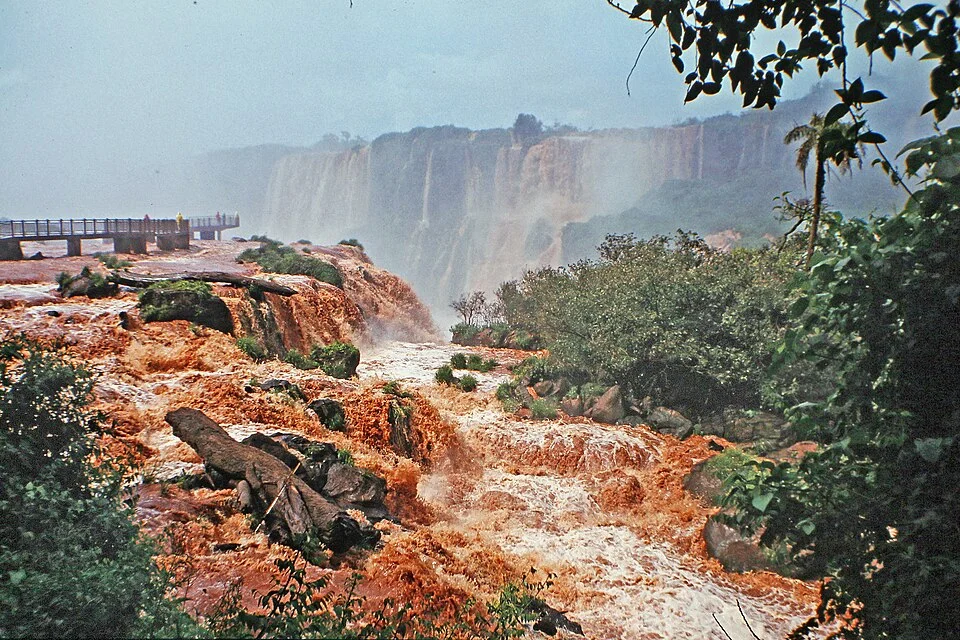
The first water in W. Bulach’s photograph of Iguazú Falls is rusty in colour and close enough to show where it breaks around rock. Farther back, rows of pale falls appear through spray. There is room for both near and distant water in the same view because the river does not go over one straight, simple edge. A viewpoint on the Brazilian side can take in more than one ledge or drop at a time. It can also make an individual fall hard to see where the water runs behind another patch of spray.
The falls lie at the border between Argentina and Brazil, with national parks recognized individually on the World Heritage List. Their relationship is best seen by following the river through the landscape. It reaches a broad system of falls, divides around pieces of ground and enters narrower space below. A person trying to name every visible drop from one side may be looking at a shifting set of water paths across a more enduring shape. The farther and closer sections of the photograph give a way to study both.
A long edge is rarely straight
Imagine a view of a river from above, a little before it reaches a steep fall. Several streams of water might prefer different paths where the edge changes height or obstacles stand above the water. One path reaches the edge directly. Another turns around a piece of ground. A twist in the edge gives water a new direction just before it leaves the rock. Add those different routes together and the line of the falls from a distance can appear like a series of white curtains rather than one smooth front. The ground still joins the displayed effects into one place on a map.
UNESCO describes an extensive, curved system of waterfalls at Iguazú and calls attention to the broad volume of spray it produces. The group is so large that a view of one powerful drop is not an inventory of the others. Depending on the viewpoint, a small fall might occupy much of the frame because it passes close to the observer. Another deep drop might have its bottom hidden around a turn. The shape of the full setting is easier to understand if a person keeps both the distance along the broad edge and the drop in height below it in mind.
The same principle explains why estimates of how many falls are visible need context. At lower flow there can be a distinct gap between two streams. Under other conditions water can cover more of the rock dividing them. Whether someone calls an edge one curtain or two can depend on the physical circumstances and the conventions guiding the count. The ground across which the river moves has more continuity than any fixed listing of visible curtains suggests.
Rock gives water several steps to work with
The park study material discusses basalt in the geology of the site. Basalt formed through older lava activity, long before the modern view of water and spray. When several surfaces are exposed one above another, they can give the falls steps and ledges visible in a side view. A map following the swinging boundary of the river does not tell how many levels it passes as it goes down. A cross section offers another way to draw the corner where the fall occurs. Some parts may be steep and uninterrupted. Others can have rock projecting between levels.
Fractures and contrasts in the rock can affect which parts persist and which are more readily worn away. Given enough time, a river can take advantage of a weakness and reshape an edge. The photograph shows a particular arrangement after much of that work has already occurred. It does not say how quickly a specific lip is changing or whether any visible loose piece separated at the time of the visit. Those measurements would need observations fitted to a longer interval and a particular place in the rock. It is enough to see that the profile is more complex than a vertical line scribbled at the final drop.
There is an informative comparison between the near rocks in the photograph and the distant bands behind them. Where water runs along a close surface the eye can often follow a narrow path until it disappears. At the distant drop the river becomes an area of light and shadow. The view needs the right distance for each observation. It can reveal the separation of broad levels without supplying the dimensions of a break in the rock far away.
The space below can conceal what is happening above
Spray can make the far falls look continuous. It appears where falling water strikes rock or water below it and is thrown into air. The spread of that mist is not an exact outline of the stream that produced it. It can extend away from the most conspicuous fall, and some moving water can remain poorly visible behind it. The word height describes one aspect of a drop while the volume of water and shape of the impact affect what a person can see or hear from another level.
A photo can set several timescales side by side. The older valley and rock formations give the waters persistent places to pass. Shorter changes in flow alter which pieces of rock are exposed. Tiny droplets can move rapidly in the air and obscure a distant edge during the brief period covered by the photograph. Read those observations separately. A dense white cloud over one part of the scene will not establish how much water that particular portion had to carry throughout a season. A bare patch on another date will not tell how the underlying step came to be.
The nearer water looks brownish in the photo. A river can carry sediment or reflect light differently at various places and times. A photograph alone is a poor way to derive a precise amount of material in it. The colour helps trace paths through the foreground as an observation about the image. It need not become a separate claim about all of the river or the source of its water on that day.
Each side presents a different relation to the same place
One park can be visited or studied for a view of a different element of the falls from another. Administrative boundaries and walking approaches do not split the upper water at every edge into separate geographic stories. Information about flow coming from above and going farther downstream applies across those viewpoints. The two parks provide complementary contexts for the changing views and the forest around them. A photograph labeled with its direction or side makes it easier to put a visible arc against the right side of a map.
This is useful even for someone with no plans to visit. Compare a view looking toward the large drop with one following a side ledge. Each makes a part easy to explain in a caption, leaving the other more distant. A wide image can clarify the curve and a closer one reveal that a line of strong flow works its way past several exposed rocks before reaching another group. The relationship between those pieces of evidence matters more than choosing which side gives a single definitive photograph.
Follow the river past the part shown
UNESCO describes the falls across a width of close to three kilometres and a vertical drop of around eighty metres in parts of the system. Those figures refer to different directions. The first helps someone place numerous parts of the falls along the broad bend. The second helps locate them above the narrower water downstream. A person comparing two photographs cannot use the vertical figure as the scale of every curved ledge, nor infer the full width of the falls from any one drop.
The river carries on to meet the Paraná farther downstream. That fact puts the apparently final drop back into a longer route. The view at the falls is a change in direction and height in the middle of a drainage system. Water arriving from the upstream basin can affect the amount passing through that change. A wetter-looking scene at one location need not tell when and where the input arrived. Drawing the upstream reach, the series of ledges and the later junction leaves space for the relationship to both the land around the waterfall and the water beyond the photographed edge.
Bring the distant drop and the near step together
Return to the brown water in the foreground and the lighter curtains behind it. Pick a short reach of water you can follow and imagine drawing a line along its direction on a map. Then add the height at which it passes its next visible edge. That second mark gives the route one of its important dimensions back. The wide system is made intelligible by repeating the same exercise at several points rather than treating the loudest drop as the model for every one.
Iguazú takes the ordinary question of where a river goes and gives it many answers close together. From one side a person sees its extent. Nearby, the passage past a single rough step can be clearer. The different views belong on the same map because the water is using many parts of the same underlying edge, in several places and at more than one height.