Two Directions Through Gibraltar
An aerial photograph makes the Strait of Gibraltar look like one passage. A section through the water reveals Atlantic inflow above a deeper Mediterranean outflow.
In this story 5 sections
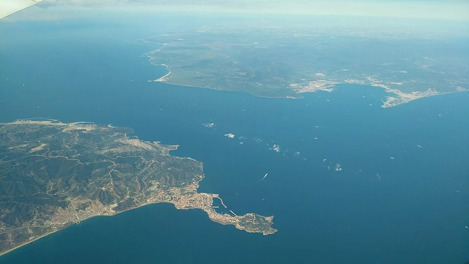
In Florian Sauerland’s photograph from an aircraft, one coast comes into the frame from the lower left and the other stretches away toward the upper right. The opening between them is the Strait of Gibraltar, a connection from the Atlantic Ocean to the Mediterranean Sea. The view makes it easy to see why the two coasts give the passage a definite shape. It makes it much harder to see how the water is using the space. You can draw an arrow on the blue between them almost anywhere. A photograph taken from above alone gives very little basis for deciding which way the arrow should point.
Scientists studying the strait describe a persistent two-way exchange, with water from the Atlantic chiefly entering the Mediterranean in an upper layer and saltier water leaving toward the Atlantic lower down. That is a description of a mean pattern. It can coexist with vigorous changes over a tide and with mixing between parts of the water column. Anyone looking at a map from above is accustomed to seeing the two shores as the walls of a passage. To understand the water's journey, add a floor with its own rises and hollows and then draw the height of the current through the space the passage leaves available.
Picture a section rather than a track across the water
Consider a cut across the strait. There are banks at both ends of that cross section, a surface and the bottom below it. Instead of drawing one velocity arrow for all the water, draw one for the upper part headed generally east and one for the lower part headed generally west. At each depth the water is using much of the same geographic opening. On a two-dimensional chart those arrows would overlap. The difficulty belongs to the chart. There is little contradiction in two currents passing the same point in plan at different depths.
A line between the arrows can help the drawing. Do not read it as a sheet of glass. A region of stronger change in density or salinity distinguishes water above from water below in a way that depends on place and time. The line can move, and water from the two regions can mix. The language of layers earns its place because it describes a broad pattern. A reader can first recover the difference between upper and lower movement and then ask where that simple picture needs more detail.
Compare two imaginary observations. A floating mark moving through one stretch may give an idea of local near-surface movement. A measurement made at depth can sample a different current. If the two records show opposite directions at a certain moment, the measurements don't have to be inconsistent. They need to carry information about where and at what depth they were taken and about the timing of the observations. The water has supplied more than one possible answer to a question asked too generally.
A difference in density links the opening to a much larger sea
The Mediterranean loses substantial freshwater through evaporation. Rain and runoff supply some water, but the balance is such that exchange through the strait is needed to understand the system. Evaporation takes water away while leaving salts behind. Water moving within the basin can acquire a different salinity and density from incoming Atlantic water. Temperature matters to density as well. The familiar big-picture consequence at the strait is a denser outflow at depth below the relatively less salty incoming water.
The word less salty is comparative. Ordinary water coming in from the Atlantic is sea water. A classroom drawing that literally labels the upper layer fresh can make the difference look like a river emptying directly into a completely separate liquid. Here the differences between kinds of sea water matter. Their density contrast is large enough to help organize the exchange while the tracer properties of the water still change where currents come together. This is one reason observations of both salinity and motion are useful. A researcher comparing them can see more than a pair of arrows separated by an arbitrary horizontal line.
The upper and lower flows carry more than a volume. In a simplified account, incoming and outgoing volumes need not balance at exactly the same value, because the wider basins have additions and losses. Their salt content is not the same either. Drawing an equal arrow in each direction can be helpful for the first mental picture and unsuitable for a calculation of a budget. To estimate that, scientists need measurements of how much of the section is involved and how the properties and movement of the water vary through it.
The narrower route and the shallower route
A flight photograph makes the horizontal narrowing especially legible. The passage has a bottom as well as a width. Woods Hole Oceanographic Institution material discusses the Camarinal Sill in the western part of the strait and the narrows near Tarifa. A sill is a raised part of the underwater terrain. It limits the depth of the path at one location relative to deeper water elsewhere. A narrows puts the shores or side boundaries closer together. They both limit the space carrying the current, but cut down different dimensions of it. The narrowest point seen from above need not be the place the bottom comes closest to the surface.
The difference is important to the lower layer in particular. Denser water coming toward a ridge in the bottom cannot simply continue along a path through rock. It can move over the sill and into deeper areas beyond, interacting with other water as it does. Its thickness and position can change on the way. A figure showing the surface route west is not enough to reckon with that passage. A separate profile along the bottom helps explain where the texture of the current changes and why conditions in an adjoining deep basin need not resemble what was observed at the sill itself.
Imagine the same two coasts with a featureless deep channel between them. Exchange would still concern different kinds of water in the basins. More of the bottom route would be available, however, and the relation between current and terrain would change. The thought experiment makes the missing line in the photograph useful. It asks what depth is available in addition to showing a visually striking gap between continents.
Tides disturb the dividing region
The two arrows give a good first reading of the passage and a poor account of a single minute. Tides add their own movements and affect the depth of the transition between the water layers. In such a channel, flowing water interacting with underwater topography can produce large internal disturbances. One Woods Hole account describes internal bores associated with flow around Camarinal Sill and waves that propagate away along the region of changing density. The important point for a newcomer is the location of those waves. They can move through an interface below the sea surface rather than looking like a train of ordinary breakers at the shore.
That makes the passage more than a site where two arrows travel straight by each other. Depth profiles made at different times can show different distributions of salinity, temperature and motion. A snapshot can help locate a structure but does not establish the mean balance. Conversely, an average over enough time can reveal a robust exchange and suppress many of the changes that matter to someone investigating the effects of tides at a particular place. Both views are useful when the timescale is named.
Some disturbance at the surface may be visible in suitable circumstances. The absence of obvious waves in an airplane photograph is not evidence for the absence of subsurface movement, just as a visible band does not identify the speed and depth of a whole layer on its own. An observer needs the appropriate measurements to give that image a physical interpretation. The uncertainty should lead back to the evidence, rather than to a claim that a large body of water is mostly motionless.
There are two useful kinds of sampling to imagine. A depth profile at a known position can help show how properties change vertically there. Repeated observations at that position can show whether the transition moved as the tide changed. Comparing two positions introduces a second dimension. It may be possible for a difference between the two profiles to reflect their locations, their times or both. Describing the observations with both coordinates and time makes it possible to relate them to the section rather than treating each as an isolated view of the whole strait.
Carry both arrows out of the photograph
It is natural to name the surface passage first, because the two continents place it so clearly. Return to the opening in the middle of the photograph and imagine one flow entering from its western side while below it another leaves the Mediterranean. Add the rise of the sea floor that neither coast reveals. Finally consider a tide changing how the moving water occupies that section without removing the larger pattern of exchange.
The two arrows are not reliable instructions for a person navigating the channel. They describe why a geographical feature easiest to show from above needs its depths restored to be understood. The photograph gives shape to a narrow opening. The measurements explain which different kinds of water can use it together, and why neither of the two shores offers the whole view of the passage between them.