Two Crossings at Pigeon Key
On the Florida Keys, the old and new Seven Mile bridges put more than a century of route decisions side by side. Pigeon Key explains why their paths still matter.
In this story 4 sections
At the small island of Pigeon Key there are two ways to think about an edge. One belongs to the water that encloses the island. The other belongs to a long route of which the island is barely a part when viewed on a highway map. A driver can go past in a few moments and retain the impression of a small green patch beside a straight stretch of road. In the history of the crossing, however, the key was a place at which things stopped, people worked and a railway project could have a station of its own, in the broader sense of a place to conduct work.
The lower Florida Keys stretch away from the Florida mainland as an archipelago. Pin a route along a length of the island chain and you are already making a string of decisions: which ground to use, what channels to cross, where a route will meet the next stretch of usable land. At Pigeon Key two structures give some of those decisions unexpected visibility. The historic bridge sits alongside the modern highway bridge for part of the crossing. One can be hard to see when the other occupies the view. In their different ways they show what a map loses by drawing the same road as a single line for every date.
Start with a railway, not a highway
Florida’s historic bridge survey traces the old crossing to the Florida East Coast Railway. It gives 1909 through 1912 for construction of the component that reached across this part of the Keys. In the early story of the crossing, the question was how to make the railway continuous over water and across a chain of islands. With platforms, track and work sites in mind, the spot looks less like a place for watching traffic on a modern road. The direction is familiar from the present map, but the institution looking after the route and the equipment using it have changed.
To see what that means, choose a short piece of railway on a map that you know well. Imagine how much a train depends on a continuous track with curves and grades that it can handle. Now set the route down on a chain of little islands and water crossings. A useful landfall is a combination of position and available space. It matters whether the available ground gives the rest of the line a way to carry on. The gap from one shore to another is an important measurement. It does not say whether a chosen crossing fits the network on either side.
A small island on such a route can contribute much more than its share of distance. Its position can give a construction operation a base close to the work that otherwise has to be supplied from farther away. The Pigeon Key Foundation describes the place as a camp for people working to build the railway. Imagine trying to repair, supply or inspect a crossing from a midway place where resources can be stored rather than issuing every trip from a distant shore. A modern map still lets you see the small patch of land. It may take a historical account to see why that patch deserved accommodation.
The deck can belong to a new transport system
The highway history of U.S. 1 describes Florida opening an improved Overseas Highway in 1938. The older railway route supplied a basis for parts of that corridor. Reusing a crossing for another purpose sounds easy if you picture only a new name on the map. Vehicles have different needs from trains. Lanes, edge space, surfaces, connections at the approaches and the places where one kind of traffic meets another all have to be considered in the new use. Some of the enduring value is embodied in piers and in the position of the structure. Other things that made sense for a train cannot simply remain.
Think of an old surface that leads to a narrow junction. An approach can be altered to feed a different kind of vehicle while much of the crossing’s position stays the same. It matters how the traveler reaches it, whether traffic can meet and where movement has to slow. To call that the same route is to talk about a path through the Keys. To call it a different route can be perfectly accurate if you are describing the ground beneath actual vehicles and the way people move between islands. Give the history both names where they are useful rather than expecting a single one to settle the physical changes.
A hurricane has a place in the story of the change from railway to highway, but a richly detailed protection history is not visible in the part of an old bridge a photograph shows. From a single exposed pier you cannot tell which damage drove a decision elsewhere, what future service was expected or how the drive between islands was changed. Begin with the known openings and reported conversions. Then look at the evidence each photograph actually supplies. Much confusion about infrastructure history comes from setting the dates according to the visual age of concrete or metal that might have been kept in service for decades.
The parallel view came later
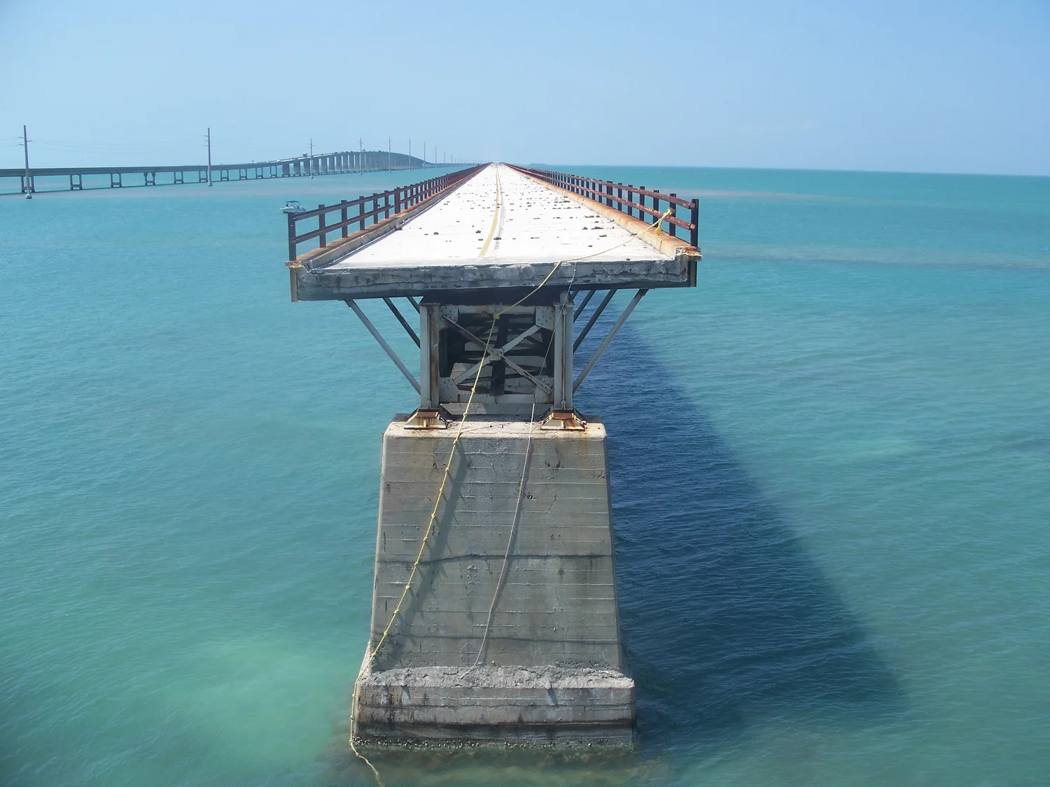
The Florida transportation department’s survey puts the opening of the modern Seven Mile Bridge in 1982. Rather than treating that change as one more deck applied to the same structure, mark two lines next to each other. There is overlap in the direction of travel, but the newer line has its own geometry. It remained able to carry highway traffic while part of the older one came to have a different job. In photographs near Pigeon Key there can be a useful interval of water between the lines. Look across it and imagine putting the whole modern road at the exact position of every old pier. It quickly becomes clear that “next to” is carrying its own kind of information.
A parallel view also helps with scale. A low line through the foreground may appear to continue unbroken because a more distant bridge fills some of the gap from your angle. Or a single structure may seem to have a wider deck because another edge lines up with it behind. If you compare old and new approaches, choose a place on a map from which the lines separate instead of relying on length relationships in the photograph. The island, shoreline and pier spacing can help you keep track of which part you are seeing. Sky and empty water do little to orient the viewer until a useful landmark enters the frame.
The photograph here shows a portion of the old crossing near Pigeon Key. It does not establish the length accessible from either direction or which route now serves vehicles. The foundation documents a restored stretch from Marathon associated with Pigeon Key. That is a particular segment with particular ends. At first glance it can be easy to think any route labeled Old Seven Mile Bridge must lead across the entire original span. A map useful to someone planning a visit has to distinguish the surviving and accessible sections from the historic full alignment.
A record of a bridge can also preserve the needs of traffic below it. The historical inventory distinguishes portions of the crossing and the structures fitted to their channels. A boat route is part of the same geographic problem, with its own requirements for space. If a drawing shows only what moves along the deck, make a separate note about the waters the deck crosses.
How to annotate a view from the water
Divide a piece of paper into three narrow rows. In one, sketch the historic railway as a route in use at a specific time. In another, show where the highway used the older crossing and note the date. In the third, leave room for the modern highway and a surviving section used another way. Keep the shores and Pigeon Key in the same positions as far as the diagram allows. That lets one principle survive all the change: any useful line here has to keep negotiating a great deal of water. The revisions show which network pays for and needs a particular route in each period.
If a photograph shows only an isolated arch or a row of supports, make its position provisional until you can match it to another visible point. People often associate every bridge in an album of the Keys with the title of its most famous span. Look for a known piece of shore or a referenced location at each end of the picture. Then see which alignment makes sense from there. This small method cannot identify every unattributed view. It can prevent a photograph of one generation of bridge from doing all the work in an account of another.
When the small island comes into view again, expect two different measures of closeness. On a highway diagram it is a name close to the line. On a map of the older crossing it belongs to a narrow segment with a reason to meet it directly. From the water it is a piece of land between moving reflections and structures that once carried quite different traffic. Every one of those descriptions can be true. Choosing the right one depends on where the traveler came from, what year the map is trying to show and whether they can leave the crossing when they reach the island.