The Tracks Beneath Antwerp Central
The station’s vaulted roof is the part most people remember. The difficult change came underneath, where a new route allowed some trains to continue across the city.
In this story 4 sections
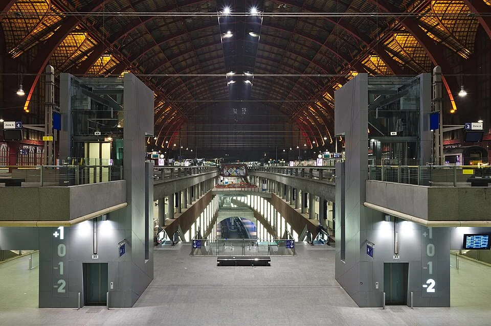
A visitor to Antwerp Central station may meet the building in its most ceremonious order: enter a grand hall, look up, and then try to decide where the trains are. The great train shed gives a second version of the same experience. It is full of structure overhead and full of long horizontal lines at the platforms. When a floor opens to show another level below it, the shed becomes a vantage point for reading the station. The tracks that seem most conspicuous from the roof are not the ones that explain the most consequential change to the route.
Here is a way to picture the difference. Take two loose ends of a piece of string and put them on opposite sides of a postcard of Antwerp. On top of the postcard, lay shorter strings that all stop near the same spot. Slip the long string underneath and let it join through that spot. The position of the station is unchanged on the paper. Its position on the long string is now in the middle. It is entirely possible to continue building and operating the shorter strings. Whereas it might have been impossible to connect them at that point on the surface, the long string has a different relationship to the city.
The old approach had an end
Antwerp’s city visitor service dates the inauguration of the historic station to 1905. It gives 2007 as the opening year of the tunnel beneath the station that made onward travel possible on the new connection. Those dates can be read as a before and after, but they do not mean one station simply replaced the other. The visible building remains a major part of where people cross between trains and city. The large rail project inserted new ways to reach it and to leave it.
At a terminus, the tracks have an end. A train arriving at one of them can finish its passenger journey there. Some trains can continue another service by reversing and using a route back toward the approach, depending on the network and schedule. This can be a normal way for a railway to work. It also makes the geometry around the approach significant: there is no through track at the buffer stops. Imagine a rail trip from a point on one side of a city to a point on the other. A station can be exceedingly central to both ends of the trip and still be an interruption in the line used to make it.
Antwerp’s lower route changes the options for trains that use it. A train able to pass through the station can continue along its onward line without having to treat the stop as an end of track. Opening that possibility does not mean every service runs through. Timetables can still end there, use other levels or serve different parts of the network. Read the terminal and through layouts as two kinds of capacity present in one place. The roof is a single fact from the city’s point of view. The routes below it let the railway give different journeys different uses of the same address.
Why the track plan needs more than one sheet
The infrastructure manager Infrabel reported that the works expanded the station to fourteen tracks distributed over three levels. Its published line diagrams make it possible to think about one level at a time. This is a sensible habit if you have ever mistaken two lines crossing on a transport map for a junction where every train can turn. The plan of a station sliced into levels has to show which lines approach the same platform height and which are physically separated.
Draw the simplest plan of an upper level by giving its tracks one approach and lines that stop. Draw the through route below it, on another piece of paper. Now place the two diagrams over each other in front of a light. A crossing may appear where a line on the bottom sheet passes under a path on the top. The routes do not join just because they cross in this view. You would need to follow each out far enough to learn where a connection between levels is possible, if one exists on that line. In the actual station the links used by people can be visible where the links available to trains are not.
For the passenger, “down” is often the first piece of a route to a platform. The lower platforms are part of the building’s geography, but the way to a platform is a matter of movements and decision points: entering a hall, finding information, choosing between stairs, lift or escalator, noticing the sign repeated on a level below. Someone going across the city by train and someone starting the same leg from the street eventually use the same platform. Their paths to it have little in common. This is a reason to design station information for both instructions that start far away and ones that become specific when you finally see a number.
Measure an interchange from the place someone starts
Two platforms can seem very close on a station diagram. One lies above the other and the representation emphasizes a shared location. A person who has just stepped off a train can experience more distance than that picture suggests. The point at which they leave the carriage may be toward an end, and the nearest usual change between floors may be elsewhere. A lift can take longer than the stairs for one person and be indispensable for another. The station’s useful distances include all those paths.
Think about a pair of arrivals into two different sides of a multi-level station. A sign installed in the middle of a concourse may work perfectly for people coming down from the entrance. At the end of a train arriving from another direction, it may be invisible until a traveler has already chosen a route. A good observation records exactly where a choice became necessary. It also records whether the path the traveler could use had a sign of its own. Drawing a very large station map can be helpful at a brief stop. It should not be the only chance a person gets to know which way to go while actually making a change.
The opening of a connection can change how a point appears in national geography without changing where a city resident walks to catch a train. For somebody who used to have to stop, turn back or use another route, there may be a new direct possibility. For somebody reaching a terminal train near the top, the routine can continue to look familiar. Whether a particular journey actually became simpler requires a comparison of the relevant services in two timetables. The building gives you the reason a new service could be operated; it does not itself choose the departures.
A platform also has to make sense as a long space. Looking down through an opening in a station, you may see only the part alongside a stair or a balcony. If you are imagining where a long train stops, that glimpse may leave out carriages beyond the limits of the view. Look for the platform number again at the far end. Repetition makes it possible to keep your bearings when the rest of the level is out of sight.
Separate the evidence from the impression
In the photograph, the station shed is visible from a high vantage. There are visible openings and different depths in the interior, and it is natural to infer that the lowest visible track is the lowest track in every picture. Platforms and railway machinery can extend beyond where the lens sees. A view straight across a level can miss tremendous changes above and below. The photo and the infrastructure diagram are complementary. The first makes the idea of an interior with multiple levels immediately legible. The second helps establish how the routes are arranged even where walls block the camera.
One quick way to compare maps is to mark a station on a city map, a route diagram and a floor plan. On the city map it is a large area or a pin near streets. On the route diagram it can be a stop on several lines with different approaches. On the floor plan it is a sequence of entrances, crossings and levels. If you begin with one of these drawings and ask it to answer every question, you can miss why the other two were made. An entrance that looks like the eastern one in the floor plan may be the closest one for a passenger whose train came from the south. A railway’s direction and a pedestrian’s direction are different kinds of description.
Back under the roof, set aside the idea that the architectural impression has to tell the whole story. You can admire the proportions and follow a departing train with your eye. The train most relevant to the north–south connection may be well out of view by then, continuing beneath the city. There is no mystery about how the address holds both journeys. One part of the station gives a route the right place to stop. A different part gives it the possibility of going on.