The River That Sinks at Škocjan
The Reka arrives in southwestern Slovenia as a surface river. A rock opening near Škocjan leads to an underground canyon, and the water is linked to springs in another country.
In this story 5 sections
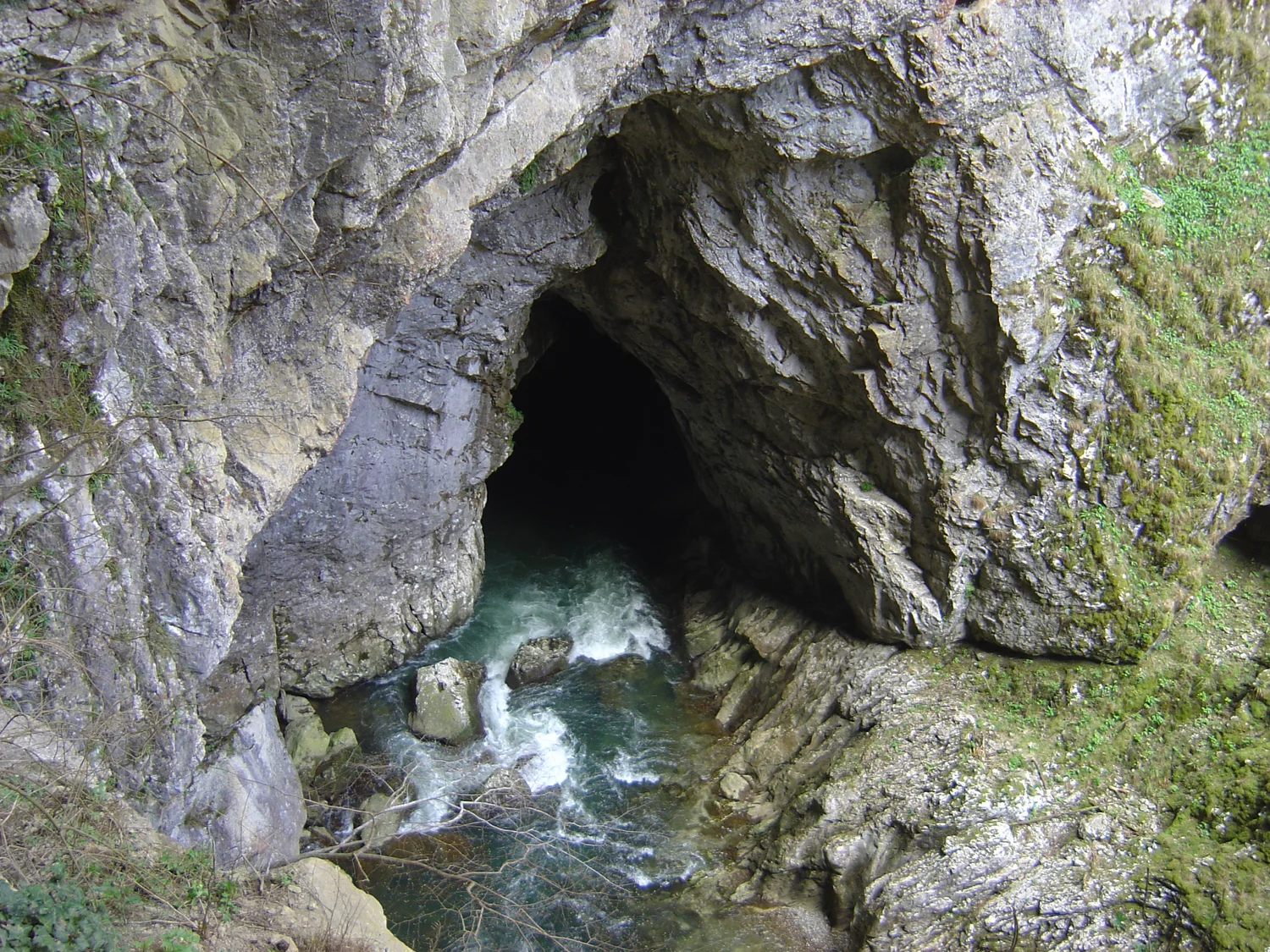
From above the opening looks like a dark pocket in a pale rock face. Water reaches it along the bottom of the image, spattering white where it passes the uneven ground. Another few metres of visible stream would be easy to draw if the surrounding rock stayed low. Here the visible line stops where the rock closes over it. The photographer known as Húsönd identifies the site as a place where the Reka disappears into the Škocjan Caves. What looks in the picture like the end of the route is where someone would have to begin drawing the route in another way.
Škocjan is in southwestern Slovenia, on the Kras plateau. UNESCO's description of the World Heritage property follows the Reka inside a limestone system with a great underground canyon. The regional park also traces the water farther west, to the springs of the Timava in Italy. That linkage is easier to state than to illustrate: much of the intervening underground route cannot be observed directly. The useful story is therefore not that a river vanishes and turns up again by some trick. It is about what different parts of the ground let water do, which parts of the route can be seen and what changes when the river brings more than a confined passage can readily carry.
Follow the water that reaches the limestone
Rain falling in the upper part of the Reka's drainage area meets rock that the park describes as relatively impermeable flysch, made from a succession including sandstones, conglomerates and marl. Much of the catchment's water gathers into a surface stream. That puts the river in a different position from rainwater landing in a crack directly over a cave. When the Reka gets to the limestone it already has a channel and a substantial supply gathered across a wider area. The opening in the photograph can be seen as a meeting place between those two circumstances.
Limestone provides ways for water to move that aren't obvious from looking at an intact block. Beds of rock meet along boundaries. Faults and fractures supply other lines of weakness. Water can enter along some of them. Where conditions allow, water carrying dissolved carbon dioxide reacts with the carbonate rock and removes some material in solution. A very narrow passage may slowly grow into a larger one. A concentrated stream with sediment can also wear its route mechanically, particularly where the bed is rough and the water moves quickly. What the river can use depends on which openings connect, their elevations and how much space there is at the tightest parts.
This is why the stream's path cannot be predicted by imagining water finding the nearest low point on a surface map. A contour line is informative when all that matters is the shape of the ground above. It cannot show where fractures beneath that surface can join into a passage. Geological maps and cave surveys help answer that question in different ways. One can show what kinds of rock and structures are present; another can record where a reachable part of a void actually turns.
A whole ravine that you could miss from above
The UNESCO account describes an underground canyon on a scale a reader might otherwise associate with a river in the open air. There are high walls and roomy chambers, stretches of fast water and falls. A photograph of one entrance does not tell you the width and height of those parts. A small opening at the surface may guard a much larger space, just as a large-looking arch at the surface may lead past another ledge into a tighter passage. The view from outside is particularly poor at showing a change of vertical scale that happens after a bend.
A normal river map can give one line the full length of a tributary. At Škocjan different portions of the underground system can lie at different levels in rock. Older openings may survive above the route taken by water in ordinary conditions. The park notes evidence of the river occupying higher channels in the past. A vertical section helps to place one passage over another without treating them as the same channel. It also lets someone ask whether a high opening comes from long-term incision or whether it can be reached by water only during an unusually large flood.
The relative positions matter for things other than the path of the river. A sheltered ceiling reached by slow drips can have mineral deposits built from water arriving drop by drop. A place regularly reached by a current carrying sediment offers a different set of conditions. Both may be inside the same cave. The look of one chamber need not describe the process doing the most work in the next. It makes sense to inquire about which water was there, how fast it was moving and how often it could reach the surface in question.
A large chamber does not guarantee a free exit
During heavy rains the Reka can send very different volumes of water into the cave. The park's hydrology account reports floods in which the underground water rises a long way. There is no straightforward proportion between that rise and how broad the river looks at the entrance in a picture. What matters underground includes narrower sections and parts of the system the river can only pass through as fast as their shape allows. Many places can temporarily hold more water if the rate coming in exceeds the rate that can move on.
Imagine pouring into a broad bowl with a narrow opening at the bottom. For a modest inflow the bowl might stay nearly empty. With a much greater inflow it fills even though its opening is still working. A limestone canyon is far more complicated than the bowl. Water can move through different branches under different conditions. The analogy clarifies why one broad section of the river tells a visitor very little about the maximum height water can reach. There is likely to be a constriction or a particularly difficult passage out of sight.
The same difference applies to what can be learned after water recedes. Signs that water once stood above its ordinary level describe a reached elevation at a point. They are not a direct measurement of the total discharge on their own. To build the wider picture someone needs a survey, observations about flow and an account of where the particular evidence comes from. Very different events could leave broadly similar marks at a muddy edge. The regional park draws on information beyond the appearance of any one rock surface when it describes the range of flow.
A river connection beyond the protected boundary
The park identifies the Timava springs in Italy as a point where the water from this system returns to the surface, roughly thirty-five kilometres away. That is useful as a geographical comparison, not as a statement that the underground path measures thirty-five kilometres if you follow all its turns. The park describes inaccessible or water-filled stretches and only a few places where people can reach the water along the intervening route. It is possible to know a hydrological connection exists without knowing each bend, chamber and split in the rock that makes it possible.
This is where careful map design matters. A line under the landscape could be read as an exact route if it uses the same solid style as a surveyed surface channel. A different line or an explanatory label can preserve the distinction between observed and understood. Indicate what is visible in the cave and what is a known connection beyond it. A reader is then able to understand why some statements may be confidently made and why there is not a complete picture of every point between the sink and springs.
The catchment matters, too, even when its upstream portions look like a different landscape. A river carries the effects of the conditions in which it gathered its water. A boundary placed around the most striking cave chambers does not detach them from flows arriving above ground. Concern for what happens upstream makes sense independent of where a photographer stands to show the entrance. Seeing which streams, slopes and rock boundaries contribute to it turns the cave into part of a drainage system rather than a single attraction with one visible doorway.
A missing line on the page
The water in the photograph is as easy to follow as most photographed streams until it reaches the shade. For a short distance it can be read the way any visible channel can. After that it takes separate pieces of evidence to recover a sense of its path. One supplies the geology that helped it enter. Another describes an underground canyon older and larger than the dark patch in the image leads a viewer to expect. Information about springs extends the picture out of Slovenia again. The bends between those accounts do not all have to be filled in by a speculative drawing.
Seen this way, the end of the line on the surface is an honest place to change map symbols. The Reka keeps moving. A viewer standing a safe distance away can only see it as far as the lip of rock permits. A map that takes both facts seriously is more revealing than one that pretends the photograph shows the river's last few metres.