The Rim Above Crater Lake
A lake in southern Oregon occupies only part of a collapse basin. From the rim, from a boat and from a depth survey, the same valley reveals different parts of its volcanic history.
In this story 5 sections
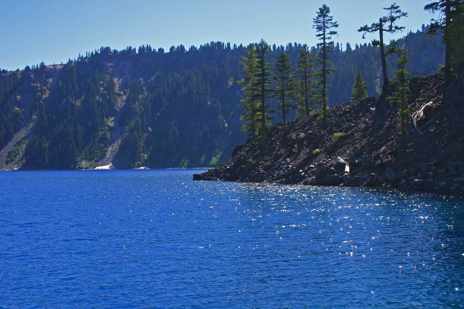
From near the water in Mark Gorzynski’s photograph, the place feels more enclosed than it might from a road somewhere above. A nearer piece of ground juts into the blue from the right. Opposite it is a steep, dark slope that continues upward to a wooded line. The sky occupies little of the photograph. There is no easy place for the eye to carry the water beyond the valley. The image is from Crater Lake in southern Oregon, and the site of the photograph is associated with Wizard Island. Both the island and the walls around the water belong to the story of an old mountain, but they were made at different stages of it.
The name Crater Lake points the reader toward a high volcanic setting. Geologists use the term caldera for the broad collapse basin that holds it. A crater can be a smaller depression around a vent; a collapse on the scale of this basin demands a different picture of what happened to the mountain. The rim is where a viewer can begin to reconstruct that difference. The shape visible above the water has a continuation below it, and the youngest recognizable volcano in the view is only partly seen.
A mountain can lose the space that holds it up
It is natural to imagine a hollow on top of a volcano as the result of something taking material away from the immediate surface. At Mount Mazama, the National Park Service and U.S. Geological Survey describe a major eruption roughly 7,700 years ago followed by collapse as magma was withdrawn and the central portion of the volcano lost support. The summit region subsided into a broad basin. The missing mountain was not simply a plug thrown intact away from the middle. Material left the system in one set of events and a large part of the mountain moved down in response.
Think of the shape from the outside first. The slopes of the older volcano and the modern rim can reveal evidence of formations that no longer continue inward as they did when the summit was present. Deposits in the walls record a history of growth and eruption that took place before the basin acquired its latest shape. They also give a person reasons to see the steep wall as a cross section rather than a boundary built at the same time out of identical material all the way around. The rim marks an interruption in the earlier landscape.
The visible opening of the basin and the visible surface of the lake have different outlines. The opening lies where higher terrain turns down toward the basin. The shore lies where the water happens to meet the ground. If the basin had no lake, the rim would still exist. If the lake rose a modest amount, its shoreline could shift while the height and shape of the rim remained nearly as they were. It helps to keep the words for those boundaries separate when reading a map whose single blue patch can seem to stand for both.
The basin did not simply wait to receive water
After the collapse, volcanism continued within the larger depression. The park describes activity that built the beginnings of Wizard Island while the caldera was still filling. The landscape thus has a steep enclosure inherited from one event and a cone constructed inside it during a later part of the sequence. If a new cone had reached only to a level far beneath today's water, someone studying the view might never have known where to look. Wizard Island is conspicuous because part of it rises above the present waterline.
This history has two scales of work going at the same time. Rain and snow were adding water. Eruptions and movement of rock were changing the floor into which that water collected. A beginner might reasonably draw a dry finished bowl and then fill it in one step with blue. The drawing can explain that a lake occupies a basin. It does not capture how relief developed inside the bowl. More detail would allow the volume of water and the position of new vents to vary over time. Parts of the land could have looked like different islands as water covered or revealed different elevations.
From the shoreline view, trees and rock give the visible island a definite edge. Below the surface there can still be a slope leading on down to part of the volcano not in view. In that respect the island in the photograph is like a peak seen above a fog bank, though the fog in this comparison stays in place instead of drifting away to expose the rest. A map of the bottom is needed to give the concealed slopes their own shape.
The lake has a balance instead of a visible exit
Water reaches the depression through precipitation and inflow from within the basin. The National Park Service describes seepage and evaporation as important losses. You do not have to picture a large river carrying water away through a notch in the rim to understand why the basin is only partly filled. Water can go into the surrounding ground and out into the air while new water arrives. Over time the gains and losses can keep a broadly persistent level, with fluctuations along the way.
Imagine following a portion of water from snowfall. Some is already over the lake when it arrives. Some falls on land that drains inward after melting. Water placed on a slope that drains outward beyond the rim belongs to a different path. Both situations can occur close together at high ground. A map's line showing the boundary matters for hydrology because it helps place rain or snow in a drainage area. It also shows why snowfall on a mountain cannot be translated directly into a corresponding rise in the water without knowing where it fell and which processes led it elsewhere.
A photograph of one bright day presents another trap. It can show shore that was uncovered at the moment of exposure, not a complete account of level or clarity through the year. Direction of light and the surface's motion change the apparent colour. A durable explanation of the lake's water budget depends on observations and physical connections that carry through several seasons. The picture supplies a good question about the blue foreground and steep slopes. It is best used to locate questions a closer measurement should answer.
Soundings give the blue space its form
Researchers used a modern multibeam survey in 2000 to map the floor in detail. In broad terms, such work uses the travel of sound down and back to build up knowledge of depths over a wider area than a few isolated soundings would cover. The U.S. Geological Survey describes how the data distinguished features including Merriam Cone, the central platform and a small dome on the side of Wizard Island. They are not details that a photograph of the water can reveal no matter how sharply it is focused. The blue area between the shores is not a blank space as far as the rock is concerned.
There is a difference between detecting a shape and explaining when it was made. If a survey shows a cone or a sloping contact, its form and relation to neighbours suggest questions about relative age or origin. Earlier sampling and other observations help distinguish among possible accounts. Measurements of rock and dates give geological context that soundings alone cannot supply. Conversely, a sample without a detailed record of where it came from may say less about the shape of the whole basin. The shore photograph, the depth survey and the geological observations make different contributions.
A depth chart also changes the comparison between landforms. A person might treat the visible tree-covered island as the whole of one volcano and the rest of the lake as a level surface beside it. In the depth data the island has much more below it and sits alongside other places where the floor rises. The outer rim still matters because it encloses those features. It is no longer the only shape available to explain why the scene looks as it does from water level.
Put the older and younger lines back together
A view from near the water gives a sense of enclosure. A view from the rim can include the wider outline of the basin. Surveying below explains why a narrow foreground cape can be part of a much larger form. It is useful to keep all three views in mind when saying which landform Crater Lake is. The bowl and the water are distinct, and Wizard Island is neither an accidental outcrop left from carving the basin nor a complete picture of what formed within it.
The far slope in the photograph was part of the setting before the lake occupied so much of the available space. The piece coming in from the right gives a look at what later grew in that space. Through them there is a path from a volcano that lost height to a basin gaining water and new relief at the same time. The water makes most of that path invisible at the very moment it pulls the separate lines into one recognizable scene.