The Polygons at the Giant’s Causeway
A close view of the basalt pavement shows that its columns do not all have six sides. Look down at the ends and then across the cliffs to see two views of one cooling and erosion story.
In this story 5 sections
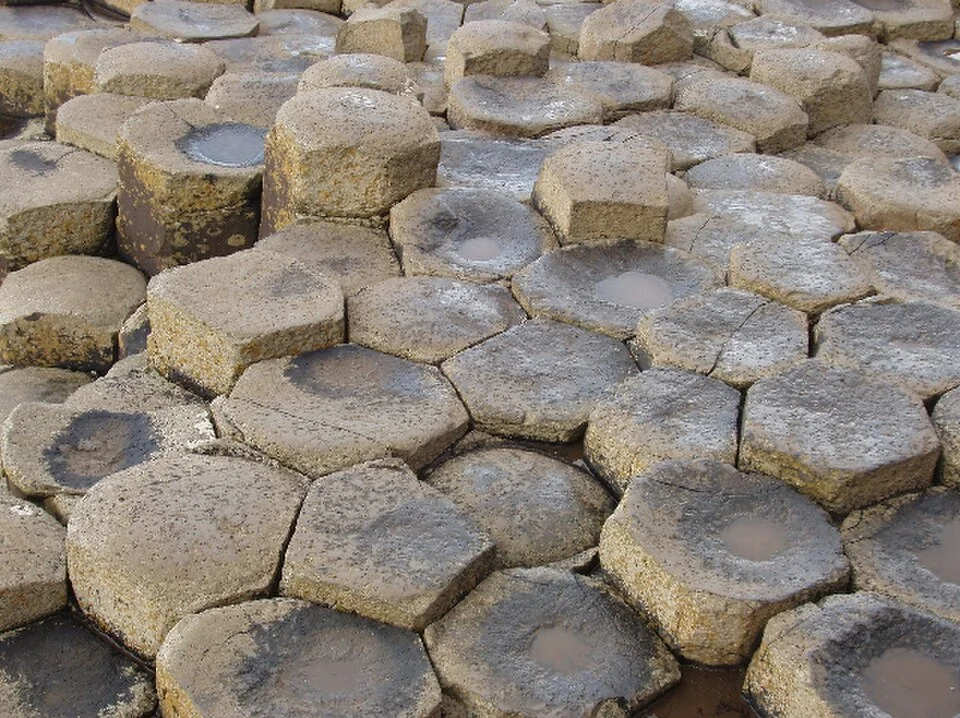
The first surprise in David Hawgood’s photograph of the Giant’s Causeway is what happens if you try to count six sides on all the stones. Several outlines look like pentagons; others are less easy to name. A slim dark gap runs alongside one edge and changes direction at its neighbour. Some corners look softened. This is a small patch of a great basalt outcrop, chosen in part because it complicates the usual drawing of a regular honeycomb. What appears at first to be a tiled surface is, in many places, a view down into the ends of adjacent columns of rock.
The Giant’s Causeway lies along the coast of County Antrim, Northern Ireland. UNESCO describes a pavement of about 40,000 columns and identifies cliff exposures elsewhere in the heritage property as evidence of successive volcanic activity. It places formation of the basalt tens of millions of years ago, about sixty million in broad terms. Much of that time cannot be seen in a single photograph. What can be seen is a relationship between the shapes on a surface and the lines that continue down through the rock. Start with that relationship and the familiar word causeway becomes less misleading.
First there was a thick body of lava
One can draw the history in two stages that are far apart in time. In the first, volcanic activity brings lava into the area and it cools to become basalt. The site's management plan describes multiple flows and intervening weathered layers along the coast. It places the recognizable stone pavement in a lower part of a basalt unit that filled older valleys. The current round-edged outline of the pavement should not be taken as the original outline of a river of lava that stopped just there. The amount and distribution of rock changed greatly before the coast had its present shape.
Basalt can take on different appearances according to the conditions in which it forms. The exposed faces at this coast include well-ordered groups of columns and other areas that look much less regular. At the scale of the photograph, it is easy to think every stone took a distinct form in isolation. That reverses the sequence. An initially continuous body cooled. It contracted and fractured within its own volume. The separation visible between two pieces records a break that affected them both. At a junction, a break arriving from one direction also meets the results of breaks already nearby.
Detached stones may sometimes litter the surface of a rocky place. A photograph by itself cannot certify which ones remain connected to the full length beneath. A view that shows several outlines and enough of a side to see their continuations is better evidence of how the pavement relates to the underlying columns. This is one reason to compare the low pavement with the taller rock faces nearby, even when the higher faces do not look much like a paved street.
A pattern made by shrinking
Cooling basalt loses volume. If the contraction cannot happen freely, stresses can rise until cracks begin. Neighbouring cracks divide the surface into a network. The result resembles dried mud in one narrow respect: outlines develop in a material pulling apart rather than as pieces laid separately from a pile. The comparison does not make the underlying processes identical. Hot rock is not a material drying out, and a joint at the Causeway can continue for some distance below the surface where a visible outline meets the open air.
As cooling proceeds inward, the fractures can extend inward too. They define columns broadly oriented normal to the cooling surfaces in the simplest case. A pattern seen in a cliff can also bend or change its spacing where the conditions were less simple. An exposed view with near-vertical lines at one point and less ordered ones higher up is not evidence for two different groups of people stacking rock. It gives a reason to look at how the surroundings and geometry of a flow changed from one part to another. The management plan uses terms borrowed from architecture, including colonnade for the especially orderly part and entablature for an often more irregular zone above it. The words help distinguish shapes; they do not imply builders.
The honeycomb comparison earns its place when it helps someone see how pieces share their edges. It becomes less useful when it makes the pattern sound mathematically perfect. A map of several columns has a history of small decisions made by the rock as fractures grew and met, rather than a grid of hexagons laid down at the outset. The pentagons in Hawgood's photograph make the difference readily visible. The shape of an individual piece can look irregular while the group fits together closely because the edges were formed in common.
The view down and the view across
Looking down brings the outlines into focus. Looking across turns some of those outlines into vertical lines. In a quarry wall or cliff, a tall column may show its long dimension but leave very little of the recognizable polygon visible. The familiar pavement is roughly a cross section: the eye can see several ends together from above, or it can look over a series of slightly different elevations from the side. What appears to be a stone step marks the point where adjacent ends are exposed at different heights. Some columns also exhibit fractures across their length, a second direction of break from the ones that separate the adjacent tall pieces.
Compare that with a bundle of pencils. The view at one end is good for seeing each outline. The view at the side is good for seeing length. That is about where the comparison stops. The edges of basalt meet irregularly. Their upper ends can be broken or rounded, and their long sides formed next to their neighbours. The same drawing cannot tell you at once which surfaces are products of cooling and which have been altered or exposed later. For that it helps to follow several features from the top of an exposed outcrop to its side instead of staring at one beautifully shaped end in isolation.
Scale changes what counts as evidence. A close photo lets a reader compare the number of sides; a view of the cliff reveals that several flows or altered bands can stack. A headland seen from farther off shows where the sea meets the exposed rock and where it does not. None cancels the evidence of the others. Each tells a person which portion of the land it is possible to ask a question about.
The sea shows edges it did not make
Waves and weather later worked the coast, revealing parts of what had been hidden and removing parts of the basalt. The fractures give water and other processes lines to follow. The management plan describes the main causeways as coastal exposures of the lower columnar layer. There is a large difference between making a row of joints inside basalt and exposing the portion a visitor sees today. The sea has helped with the second. The distinctive long boundaries have their origin in the earlier cooling of lava.
A dark gap in the photograph need not carry a single message about the age of the surface. It may show that two adjacent columns have separated perceptibly at the top, or simply that sunlight is reaching one edge at a better angle than the other. A shallow basin can collect water from more than one source. The rounded corners may reflect exposure without making it possible to assign the rounding to one particular storm or season. A photograph published with a named location is strong evidence for the appearance of that patch on one occasion. A site description is needed to make a statement about the surrounding rock or the sequence of events that brought it into view.
What makes the named site so informative is that those different views can be compared nearby: coastal sections, a broad look at the cliff and the enticing near-horizontal pavement. If the columns had never been exposed, a person might still encounter basalt along the coast without seeing how its interior was divided. If only the pavement were available, the stone tops would give much less sense of the depth and variety of the basalt units beneath or beside them.
Count around just one more time
Return to the photograph and choose a stone that looks reliably like a pentagon. A visitor tracing its outline might be stopped by a rounded corner, then find the continuation by checking where a neighbouring edge meets it. Next try a stone that looks hexagonal. Both pieces occupy space within the same network. The difference between them is no obstacle to learning from the pattern. It is part of what the pattern actually looks like.
The habit of looking for the adjoining piece also helps with the wider scene. Extend an edge downward in the mind and the picture changes from a stone street to a cut through a volume. Follow that volume to the cliffs and an individual column becomes one portion of a landscape with repeated flows and gaps between them. Volcanic rock, contraction and coastal erosion each had a part in supplying that view. The small gap beside a single polygon makes a good beginning precisely because it belongs to at least two stones.