The Park Lands Around Adelaide’s Grid
A map of Adelaide can show the garden squares, the river and the larger belt of park lands. They are three different ways of putting open space next to the city.
In this story 5 sections
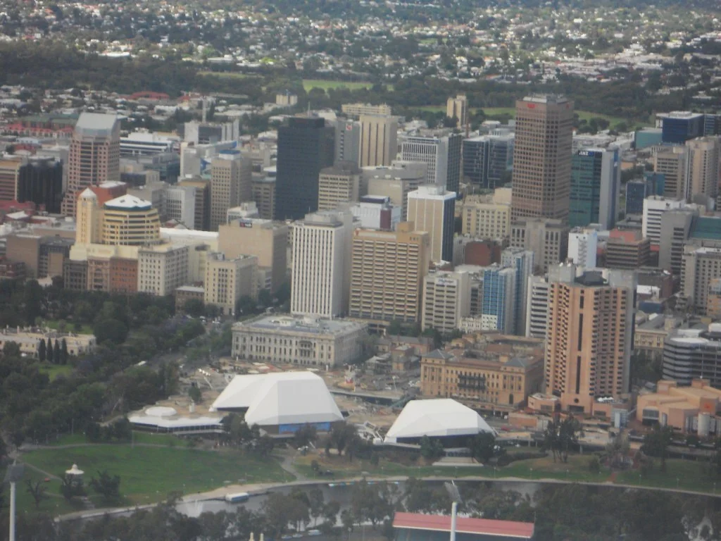
From above a regular grid of city streets makes a strong case for being the whole city. The eye follows it in long directions and understands fairly quickly where the next street might be. Look past the last few blocks in a view of central Adelaide and there is room for a different kind of continuity. Green areas and open space form parts of a much larger belt. Some can be recognized from a distance. Other parts give way to paths, roads or facilities that a single green line would never show. The task in reading the city is to keep the regular pattern of streets and the large figure around them in the same picture.
Australia’s national heritage description connects these features to William Light’s 1837 plan for the colonial city, with streets, squares, the river and Park Lands in a deliberate relationship. The plan dates a particular act of surveying and design. It is not an account of the beginning of human life on this land. Nor is everything visible in a recent photograph unchanged from that plan. What can survive through both time and change is the relation of broad components of the plan. A city center can have streets whose direction is familiar while individual pieces of the surrounding land are used in new ways.
Draw the squares before you draw the belt
Make a small grid on a piece of paper. Leave an open square near its center, and place several other open squares among the rectangular blocks. A person making a short trip through this imaginary city can pass one in the course of ordinary movement along adjoining streets. They need not reach the edge of the city blocks in order to see one. That is a different role from what you might expect of a belt of large spaces surrounding the grid. The national heritage description names several of the city squares among the significant components of the Adelaide arrangement.
Now draw another line outside the blocks and mark it as a belt instead of another street. Depending on where you cross it, the walk to another built area can have very different surroundings from the walk between two blocks within the center. It is easy for a map to use an identical green for the squares and the belt, because both involve open public ground. That color cannot give them the same relationship to the streets that approach them. The two are distinct plans for where you can meet space on an otherwise urban trip.
Think of the visit as a series of turns. Pass a square while walking inside the grid; approach the outer edge from a street ending at or crossing beside the surrounding land; enter the belt from another side. The town squares can help an observer orient themselves within the sequence of blocks. The outer open lands can help announce the limits of particular parts of the layout. Checking which position an image represents is useful before saying a particular park is in the center or beyond it. An arrangement can have a conspicuous edge and still give someone open space in its interior.
Let the river interrupt your first drawing
The river named the River Torrens and Karrawirra Pari in city material separates the major components of the historic central layout, including North Adelaide and the main city to the south. Draw it as a line with its own turns and width. The streets should not erase it simply because the grids on your sketch were easier to draw first. A river can be part of a larger area of open land and can also give particular places there a very different form. Approaches, bridges and paths belong to the relationship of the blocks on either side even when a thin line on an overview map makes the crossing look like a quick stroke.
A useful comparison uses a north-up plan and a view looking at the city from an angle. River bends and changes in the arrangement of built blocks can anchor the two. Let the shapes help identify where a green area belongs within the system. Someone comparing them may think the river is a border of all the Park Lands and overlook the other surrounding pieces. Another observer may treat it as an unrelated feature because a visitor drawn to a square could spend the whole afternoon on one side of it. Both views can become more precise once the map shows the different relationships together.
The City of Adelaide’s community land material treats the river as part of the Park Lands for its planning purposes and notes activities associated with it. The management question deserves its place next to the historical plan. A nineteenth-century drawing can establish which elements were associated with a particular design. It does not have to account for every use for which people provide today. Retaining the general distinction between river and grid makes it easier to notice where later arrangements put another path, facility or crossing into the land.
A recognized plan is not a single view frozen in place
Photographs of a city favor whatever arrangements were visible on one day. The aerial view provides an instructive scale for the relationship of open space and densely built blocks. It may not reveal every part of the belt or label the path that connects a neighborhood to a square. A defined heritage boundary is another kind of information. It establishes what the description protects or identifies, and has to be read in the official material. It is quite possible for a green element to be visible near the city without being the part under discussion in a particular assessment.
When comparing a historic and a newer map, choose stable features for alignment, then check how the rest is represented. A historical square might be divided into colors according to use in one map and appear as one block in the other. Part of the belt may be shown as property, landscape or a particular project depending on the reason for the map. An apparent disappearance can be a change in the subject of the drawing instead of a change on the ground. Find the earlier and later documents that truly address the same question before deciding the change is real.
The use of land also brings its own changes of time and scale. A large open part of the city can be used for a public event, while a nearby path remains important as a daily shortcut. A city planning for an occasional gathering has different reasons for identifying access than someone preparing a map of everyday pedestrian routes. A heritage description can clarify why the generous amount of open space matters to the layout. It cannot determine how every visitor will get across it once the local details start to matter.
Look for what crosses the green line
A large belt of land can give the eye an impression of unbroken space on a regional plan. At ground level, several lines have to go across it. A river crossing joins particular street approaches. A path can create a much narrower crossing in another place. A street passing through the open land can carry somebody across it without placing them close to an entrance useful for spending time there. Try using a different line for each purpose. People reading a smaller map will then have a way to see whether one crossing replaces another or simply offers a different use.
At the same time a park boundary is a record of one spatial extent. Do not mistake the edges of green in a photo, which vary with vegetation and the season, for a surveyed line. Put an observed tree canopy or planted strip on its own layer. Keep legal and management boundaries on maps identified by their official sources and dates. Two boundaries can coincide across a small area and then diverge at a facility or a visibly altered place. This is where a photograph most rewards careful comparison with a map.
Read a boundary from both sides
Pick a location in the view where a group of blocks almost meets a broad open area. Ask what the boundary would look like from someone walking out of the blocks and from someone coming back. The arrangement may feel continuous in one direction because a sightline reaches across it. In the other direction a road or a change in path can make arrival at the grid sharply apparent. Whether the belt is useful to the person in motion can depend on the ways people are able to cross it as well as on the amount and position of open land.
Draw the squares, river and outer land again, this time on the same sheet. At a glance the city shows several kinds of open space that resist being summarized by one total of green ground. A square gives the grid an interval. A river gives the setting a direction of its own. The surrounding lands give the city several edges to cross. This is why the map is worth keeping beside the photograph: it explains how the open spaces continue beyond the part that happens to be visible from above.