The Border That Enters a Shop
In Baarle, a marked line can leave the pavement and cross a building. The nested Belgian and Dutch enclaves make more sense on a map that distinguishes borders, addresses and routes.
In this story 5 sections
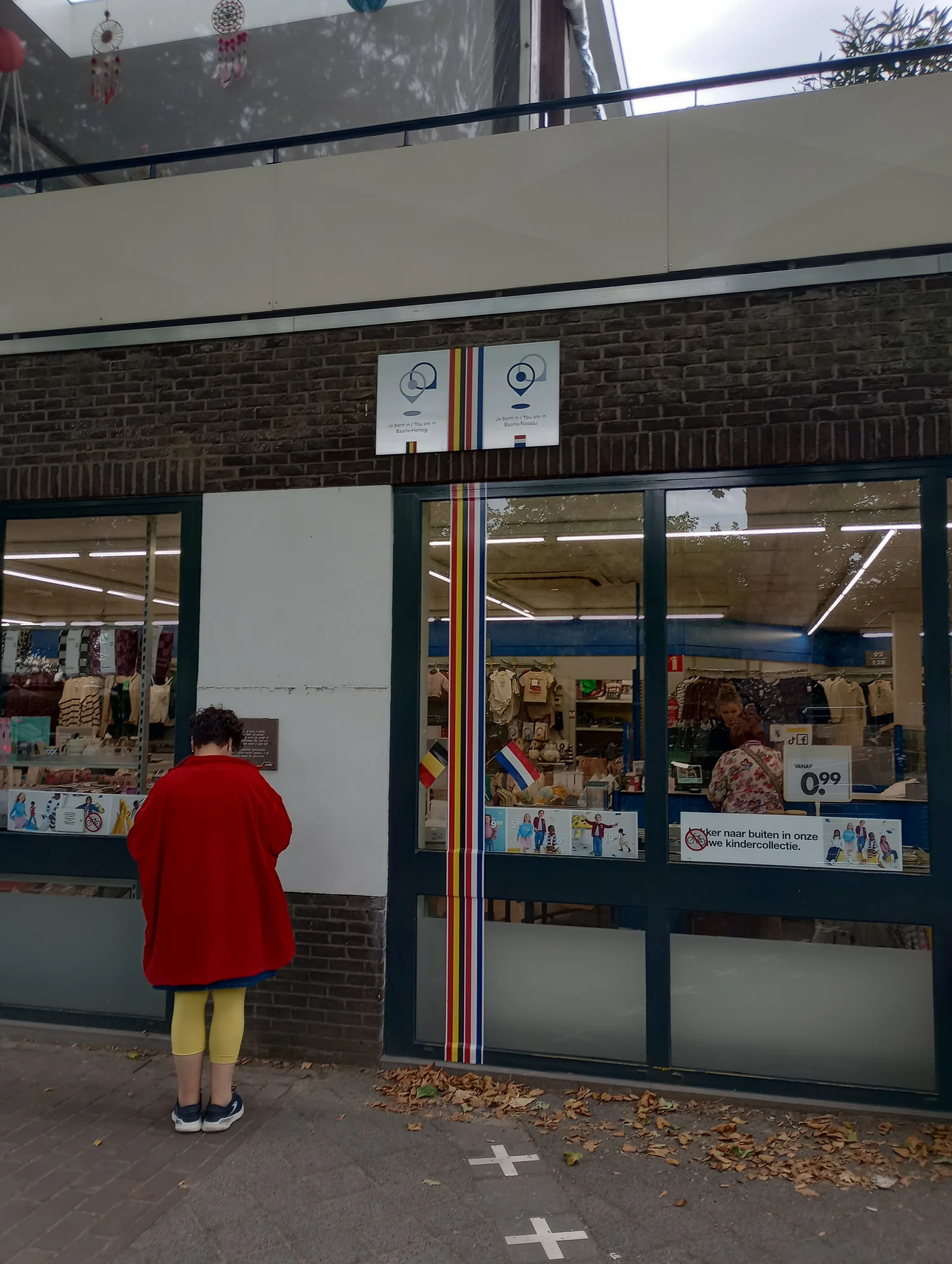
The marked line on the pavement has a destination that would be impossible on most familiar border maps. It runs toward the front of a shop. In the photograph by Kayfabebaale, the marked boundary continues onto the facade, with Belgian and Dutch labels near it. The building does not end at the line. Its entrance and display occupy the ordinary space of a local street. The effect is easier to believe at pavement scale than when one tries to draw two countries meeting on a classroom map.
The Belgian municipality of Baarle-Hertog describes its setting alongside the Dutch municipality of Baarle-Nassau as a group of enclaves rather than a town separated neatly into two sides. That distinction explains why a person can cross a marked line and encounter another line without walking toward the frontier usually drawn between Belgium and the Netherlands. The shape of the countryside and the name of a town do not supply all the polygons needed for a useful local map.
The line goes around an area, even when you see it as a crossing
An enclave is territory surrounded by the territory of another state. From the viewpoint of a passerby, it may look like a short stroke crossing the direction of travel. From above it belongs to a closed boundary. Treating the pavement mark as one end of a straight line gives no hint that the territory can be left again only a little farther along. Several nearby strokes may mark different parts of the same perimeter or parts of different enclaves.
Baarle-Hertog's account identifies twenty two Belgian enclaves surrounded by the Netherlands. Within two of the largest Belgian enclaves it identifies seven Dutch enclaves. It also names one further Dutch enclave to the south in Belgium's main territory. Those counts explain how a diagram can need a hole within a patch of territory that is itself a patch within another territory. It is more precise to show the nesting than to say the map merely has many bends.
A plain sketch is enough for the logic. Shade the surrounding Dutch area. Place a Belgian patch within it. Put a small Dutch patch inside that patch. A line drawn from the surrounding area through the inner patch would cross Belgium's boundary, enter the inner Dutch territory and leave again if extended far enough. The inner patch is still separate from the surrounding Dutch territory. Colour alone may make the two seem joined. The closed outlines show why they are not.
Maps and pavement marks solve problems at different scales
A national map could reasonably omit tiny features at a scale where drawing them would make a dark blur. A town map has a different purpose. It can show the street and the change in territory within the same view. Pavement markers bring the scale down further, to the distance a person can step across. The Baarle-Nassau town-centre master plan describes the use of special paving and markers to make enclave boundaries legible in streets. It specifically discusses the relation of visible lines to local public space.
Putting a marker in a pavement is useful because a true line has no width a person can readily see. The marker has its own material and width. It guides attention to the boundary without turning each edge of the marker into a separate legal boundary. The same qualification applies to a printed map. A heavy line can hide a narrow feature or seem to coincide with the side of a property simply because the scale is small. For precise questions one needs the agreed records, not a measurement from pixels or paving alone.
The photograph gives another reason to keep the scales distinct. A border line that continues up a facade gives the viewer a way to imagine where it meets the building. The photo does not permit a survey of the plot behind that facade. It cannot tell us how an internal wall is placed or settle the location of an address. It gives something the large map does not: a visible moment in which someone's ordinary experience of a shop includes a territorial seam.
The town-centre plan notes visible boundaries at places such as the Singel and the area of Loswal and Stationsstraat. They are useful examples because the surroundings are not interchangeable. A crossing in a public square can be marked across a fairly open surface. A line arriving at a facade asks for a different explanation. Both can remain recognizable if the public realm is altered, but a replacement marker needs to work with what is actually at its edge. Understanding the border on foot thus depends partly on an ordinary maintenance question: can a person still see where the marks carry the line from one surface to another?
The front door answers a particular administrative question
The municipality of Baarle-Hertog explains that the location of a building's front door determines which country it is registered in, including cases where the border crosses the building. It makes that point in guidance about building numbers. This is a useful detail because physical occupation of a surface and administrative treatment of a building are different questions. The door rule makes one determination possible without pretending the building stands entirely to one side.
A comparison with a house number elsewhere helps. An address might send a delivery to a door facing a particular street even though the building takes up much of a block. Somebody who follows the address needs the entrance rather than a line through the middle of the building. At Baarle, the position of the entrance has an additional stated administrative role. That role does not erase the boundary line visible on the facade. A map that shows both can describe one site more fully than a label pinned at its centre.
The official municipal explanation is about registration and numbers. It should not be stretched into a claim about every rule that might affect a business, resident or visitor. Actual legal questions need the proper authorities and documents. For understanding geography, the valuable observation is more modest. One building can have a footprint that crosses a boundary and be entered and recorded through a particular door. The line and the address both describe it, but do not do so in the same way.
A route is easier to follow than a collection of tiny polygons
Begin at a place where a border marker can be identified without trespassing or depending on the use of a shop. Locate the same point on published mapping. Then look in which direction the boundary continues. A familiar street can make it seem that a line will simply follow the curb for a while. The plan could show it departing in a direction a person cannot follow on foot. That is a reason to distinguish seeing a boundary from being able to trace its full course in person.
A town guide can give a visitor a short walk crossing several marked places without implying that it describes the entire enclave system. Someone preparing a map for that purpose can show several points where a path and a boundary intersect, instead of putting every outline equally prominently in a small image. A survey plan can make different choices. The public markers are interesting partly because they make an actual street useful for reading a small part of a much larger arrangement.
There is a practical map-reading benefit in labelling which line is a border and which is a path. In a neighbourhood diagram several of each may run close together. At a bend, the walker should be able to stay on the path while following the territorial line with their eye. A label placed only at the first intersection can leave the reader guessing on the next page. Once the two meanings are clearly marked, it becomes entirely possible to understand the map without trying to walk on every line it contains.
The shop is one place with two geographic questions
A legend can mark the municipalities as well as the territories without assuming every type of boundary should be read the same way. A visitor wants a street and landmark. Someone comparing municipal plans may need the separate source and publication date. A third person may be simply trying to draw the nested shapes clearly. Providing each with a relevant reference preserves what made the first photograph interesting.
Return to the facade in the picture. One question is where the boundary goes: the marker shows it crossing the place occupied by the building. Another is how to enter or address the building: that requires the relevant door and city information. On a little sketch each question could be answered with a different mark. Give the first a line continuing out of the frame and the second a point that connects to a route along the street.
The visit to a shop will not usually require someone to recall how many enclaves are on the whole map. The map of the enclaves, however, becomes more memorable when it has a building and a pavement in it. The photograph keeps the border at the scale of an afternoon's errands. The plans recover the closed shapes that make the short crossing mean something. The shop helps explain how both scales can describe the same place without producing the same picture.