The Date Line Does Not Live on a Meridian
Taveuni gives the 180th meridian a visible address. The International Date Line reflects separate decisions about how places keep their calendars.
In this story 5 sections
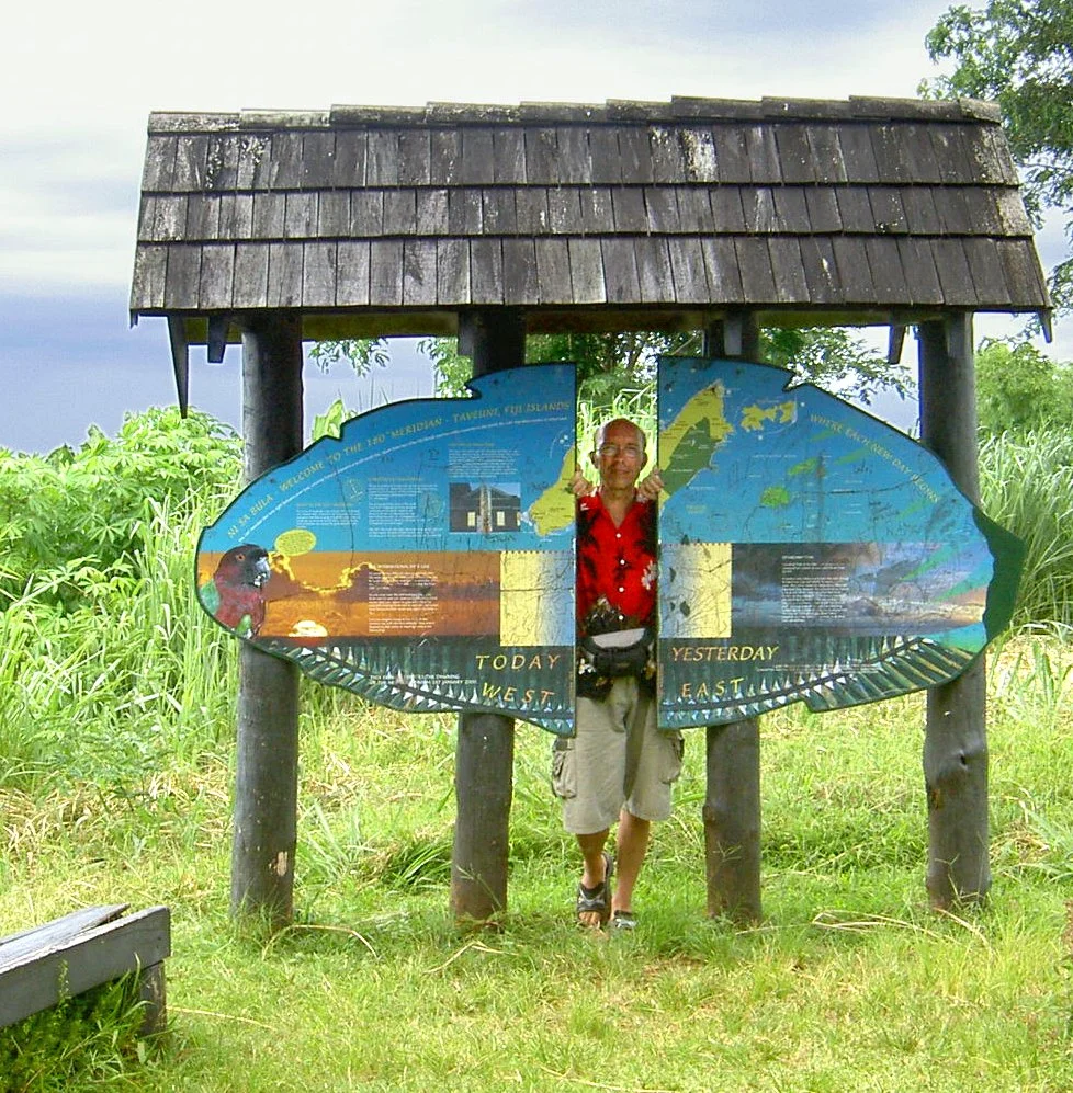
The sign on Taveuni makes a strong offer to a visitor who wants to be in two days at once. It identifies the 180th meridian and plays with the words yesterday and today. Both sides of an imaginary line are available in an ordinary piece of grass. One side of the road has not therefore become a place where a second official day begins. A geographical coordinate and a practical division of dates can share a good story without occupying exactly the same line. The photograph is a useful beginning because it lets you put the meridian somewhere solid before you ask where the clocks are.
Longitude expresses position around the Earth relative to a reference. NOAA’s explanation starts from the prime meridian, whose longitude is zero. Halfway around the globe lies the 180th meridian. The International Date Line does much of its work in its neighborhood but does not run rigidly along it. Published descriptions show departures made to accommodate political and practical choices about dates. Fiji’s own Reserve Bank identifies the 180th meridian in its account of an item whose design marks the line through parts of the country, including Taveuni. The two references can be correct together because they identify different things.
Draw the round world before looking for a straight edge
Start with a diagram of a globe divided into degrees east and west of the reference. Points labeled 179 degrees east and 179 degrees west are quite near each other along one parallel when measured by the shorter way round. There are just two degrees between them by way of 180. On a flat drawing in which 180 sits at both edges of the paper, those points can appear astonishingly far apart. The disagreement is mostly about where the drawing was cut. A globe keeps the route near the far meridian continuous.
Now draw a second line for the way local dates are arranged. It can have bends and make room for islands on either side that people have reason to keep together or associate with other places. It does not have to stop being a useful date division because it does not repeat the perfectly straight longitudinal reference. Publishing both lines in different styles is worth the extra ink. A globe with only one of them can encourage a reader to assume the other exists in exactly the same place.
The distinction is sometimes hard to retain when naming map features. “Dateline” can be used in a caption about a meridian marker because enough readers recognize the idea. For research on time, keep the actual local arrangements and the coordinate called 180 in separate fields. For research on position, give the coordinate the reference it needs without assigning a different date to two places just because they have different labels of east and west. Longitude supplies a way to place a road. It does not by itself tell its residents what to call Tuesday.
Date differs even though everybody has the same amount of time
Time zones let local clocks display different times and sometimes different calendar dates for the same instant. It is not necessary for time to pass differently on two islands. They can label one instant differently. Imagine two fictional places using offsets of twelve hours forward and twelve hours back from a common reference. At a point where the reference shows noon on June 10, the first place reads midnight beginning June 11 and the second reads midnight beginning June 10. There is a full day of difference in the calendars though their clocks show the same hour and no additional day elapsed between observations.
An offset example is a calculation, not a claim about which actual zone either place on your map uses. Some Pacific offsets differ from those convenient values. Different practices and changes in civil time can make a location and a date both necessary pieces of a schedule. If you need to compare actual appointments, obtain the offsets and local dates from a reliable source for the intended date. This is a better way to find the time than inferring an offset from a meridian seen beside a beach or road.
A typical illustration of crossing the date line describes adding a calendar day on a westward crossing and subtracting one eastward. The larger logic is about keeping the local date consistent as you change reference. On an actual itinerary, read the places’ stated local dates and time zones rather than independently adding a day to times that have already been supplied as local times. That could apply the same correction twice. An itinerary in time can pass through many more labels than a short path drawn across the Pacific appears to require.
Move the cut on the paper
The left and right edges of a world map sometimes carry the same meridian. The effect is familiar in maps showing the Atlantic near the center, because an island in the Pacific can be very close to a cut. Find a Pacific-centered map and the same island can have room around it on both sides. Its geographical connections did not change as the mapmaker shifted the cut. A chart that needs to show relationships near the date line can solve much of its apparent fragmentation by choosing which ocean to give the middle of the page.
An exchange across that edge has at least two dates to keep. Suppose a call is agreed for 02:00 on Wednesday at a common reference. Put fictional local offices at plus twelve and minus ten hours. One person expects a call at 14:00 Wednesday and the other at 16:00 Tuesday. It is not a call taking twenty-two hours to arrive. Both are appointments for the same instant and can be made explicit in a meeting notice by giving the standard reference as well as the local date and time. It also helps to say which date is local to whom if just one line is copied into another message.
Make history and current convention identify themselves
A boundary drawn in an old atlas can be useful even if it does not match the arrangements a reliable calendar applies now. The longitude reference and the historical offsets should each be attributed to their source and date. One mapmaker might have chosen the date line’s track to describe which arrangements were known for a period. Another could have marked only 180 degrees, leaving the separate custom entirely to another page. Do not assume a bend was added or removed on the ground merely because a second map takes a different approach to drawing it.
There is a reason to keep the practical dates visible at the point an observation is made. A diary describing a place near the line could use a local date for an event. A report compiled from several places could put events into a common time reference for comparison. The dates can seem different even if both are good reports. Preserve the writer’s stated local day, then show any conversion independently, rather than quietly correcting an apparent inconsistency you may have introduced by reading the second date in the wrong frame.
This will make the two calendars rather less mysterious. A map labels positions, a clock labels time under an arrangement and a report gives time a particular use. Save enough of each label that a later reader can find the relationship again.
The farther from home a date travels in a record, the more useful it is to say whose date was meant in the first place.
What should a marker tell a visitor?
The sign in the photograph does something useful and playful. It turns a coordinate from a number beginning on the other side of the world into a line people can imagine on the ground. If its lighthearted invitation suggests a calendar change, the official explanatory sources can supply a distinction the sign need not fit into every line. A map for a traveler may want a further label explaining that the date convention and the geodetic line are not the same thing. The two signs can coexist. Their purposes are different enough that identifying them gives both more value.
Try making a small sketch of the sign, its location and the line someone claims it marks. If the reader wants to know how it was placed, ask for a record of coordinates and the relevant mapping reference. If they want to know what day to write on a letter from the island, ask about the civil time at that place. Neither inquiry needs to make the little sign represent every relationship that has accumulated around it. It can make a geographic distinction memorable and point someone toward the record appropriate to their next question.
A map will often retain straight lines, bends and edges long after individual people leave its shore. Before treating a line on it as an absolute fact of the globe, identify what was drawn to put locations in order and what was drawn to put dates in order. Taveuni gives the first line somewhere to take a picture. The habit of keeping the two lines distinct offers a way to read the rest of the ocean without expecting all the clocks to follow the meridian past the same patch of grass.