The Map Below Wieliczka
One salt deposit supported mines in two towns. At Wieliczka, a route through shafts, galleries and a chapel shows why the underground is easier to read in section than in plan alone.
In this story 5 sections
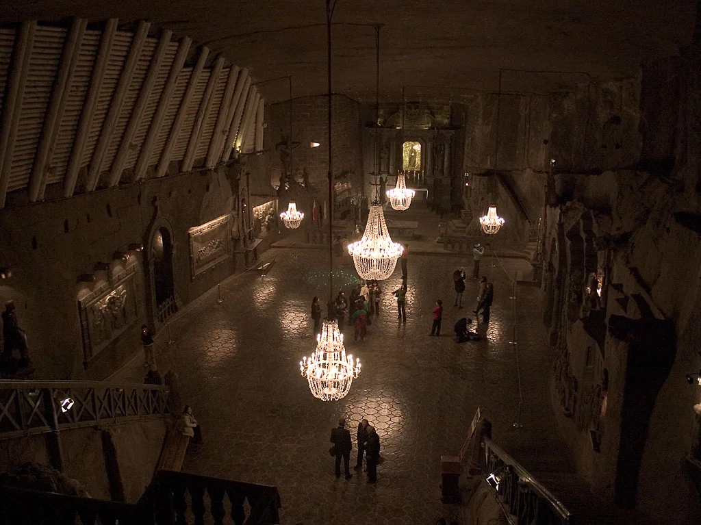
On the surface, a building such as a chapel can ordinarily be found by walking towards it along a street. At Wieliczka, in southern Poland, the relevant street starts with a descent. St Kinga's Chapel is about 101 metres underground, according to the mine's presentation of the site. A visitor in the chamber can look down on the floor and up towards chandeliers without seeing any sky. The place has the familiar scale and internal habits of a substantial room. On a surface map it may seem to cover ground which is occupied by something else entirely.
That apparent overlap is one reason to look at a mine in section. A conventional plan decides what is next to what from above. A section has space to show that two points close together in plan can lie on separate levels. For a surface walker, two points a few metres apart present an easy prospect unless a wall intervenes. Underground, getting between them may mean returning to a junction where the levels actually meet. The distance that matters depends on the route permitted by rock, galleries and shafts.
The deposit is shared; the entrances are separate
UNESCO's World Heritage description joins the Wieliczka and Bochnia mines with the Saltworks Castle at Wieliczka. Both mines worked the same rock salt deposit, in different towns. The enterprise behind them was historically connected. The fact that the geology joins them at scale is no reason to draw one continuous visitor path between the two attractions. These are separate examples of an industrial landscape, connected in evidence by the deposit and by the organisation that used it.
Think of three layers of information. Geology emphasises the body of salt. A historical account follows the extraction and administration of a valuable mineral. A route plan shows particular stretches of gallery and connections between levels. Putting all three on one page can be useful if the key says which line stands for which thing. If not, a path suggesting common management can look like a tunnel, and a shaded mineral extent can look like a chamber somebody could actually enter.
The castle is a corrective to an underground picture that has no surface. It was where the wider enterprise was administered. Its inclusion in the World Heritage property shows that the story of the mine does not stop at the face of the salt. Records, labour, equipment and decisions came from somewhere. A long gallery can give the eye a vivid impression of mining while showing little of the structure that made the work possible.
A horizontal trip is folded by descent
Wieliczka's operator identifies the Daniłowicz Shaft as the starting point for its Tourist Route. That is a concrete instruction in a complex extending far beyond the part on a public tour. Beginning with the entrance rather than a simplified chamber map is already a kind of geographic lesson. The start is selected for access. The chamber that appears on the cover photograph belongs later along a path organised by different levels of excavation.
Imagine a visitor trying to make notes about the sequence. The first record might say down, then along, then down again, before any notable room name appears. A flat tracing can show how the walk turns in the horizontal plane. A strip beside it can show how the depth changes as the visitor progresses. On the tracing two corridors could appear to cross. On the strip they can be seen to lie at different depths and never meet. Together the pictures are more legible than a plan covered in so many overlapping lines that nothing can be followed.
That principle helps explain an apparent difference between depth and distance. A descent to a nominal depth of 101 metres is not a walk of 101 metres. Stairs travel along a sloping path. Galleries travel sideways. An eventual route can turn, descend and change direction repeatedly. Before making any decision about an actual visit, check the operator's current access information; a whole-mine figure or a measurement for the chapel is a poor substitute for the route's description of stairs and arrangements.
Rooms made by taking material away
The photographs easiest to remember tend to be of rooms that look complete. The ceiling and floor of St Kinga's Chapel have a composition like that of a building designed to be seen. Mining reverses an ordinary building story in an important respect. Removing material created voids. Later changes could take an existing excavated space and give it a different function. UNESCO describes a historical complex with remnants used for chapels, workshops and storage as well as extraction.
It is therefore useful to ask two questions before trying to read a room. What sort of excavation left the space? What work made the space look as it does now? The second question admits fittings, carving and surface treatments. The first accounts for where the room sits among other excavations. A striking wall can dominate the photograph without explaining the original reason bodies of salt were removed from that area.
The operator describes a floor carved in salt and chandeliers decorated with salt crystals in St Kinga's Chapel. A visitor may find that the finished surface gives no immediate impression of a continuous mass of rock. A patterned floor can look as if pieces were brought in and laid. Light and shadow make a recess look deeper or a carving stand out. The source matters here because appearances alone could suggest a very different chain of construction.
A network made over time
A railway plan can sometimes be read as if its lines were drawn at once, even though some stretches were built decades apart. A mine with centuries of work invites the same mistake. Generations of miners opened and altered different parts. A gallery shown on a historical plan need not have served the same purpose at all dates. New routes could open while old ones were given new uses. Draw every surviving feature with the same line and the reader gets a coherent picture that might never have been true at any one moment.
One way to avoid that is to date the question. Are we trying to describe the locations used by the royal enterprise at a certain time, the voids known today, or the public route now offered by the operator? A single route sign generally answers only the last question. A conservation map may answer at least some of the second. Historical records and physical evidence together can inform the first. The special value of a complete plan lies less in making all journeys available than in helping a reader see the difference between them.
On a simple diagram one could mark excavated corridors in grey and a visitor path in a different colour. At places where the visitor route changes level, attach a small section or a depth reading. Show the buildings at the surface on a separate layer. Remove that layer while drawing the sequence of underground chambers and bring it back when asking where each shaft begins. The ability to compare two versions of the same place is more informative than forcing all the information into a single glance.
The photograph is an endpoint rather than a plan
There is another reason to give levels labels of their own. A measurement reported for the chapel can refer to a named floor, while a height measured in the room may describe the distance from that floor to the ceiling. Somebody hearing that a lamp is in a chamber a hundred metres down should not infer that the lamp itself hangs at the floor's stated depth. A section indicates which point a depth refers to. It also shows that a tall cavity may occupy some of the vertical interval between working levels without providing a passage between them.
A reader can sketch this distinction with two hypothetical galleries. Place one at a nominal depth of eighty metres and another at one hundred. Between them draw a hall whose floor belongs to the lower gallery and whose roof stops short of the upper one. A plan might show all three features sharing a patch of ground. Only the section can immediately prevent a mistaken turn from the upper corridor into the hall. The numbers in this exercise do not map the actual chapel; they show why nearby names in a key do not establish a connection.
The cover photograph has a high viewpoint inside St Kinga's Chapel. A person appears small near the floor; the tall space and lights make it easy to miss the difficulty of reaching this position from a street. Only one part of a far larger network fits into the rectangular picture. Even someone who knows exactly what the floor is made of would need another record to learn at which step their view into the room begins.
That limitation is a virtue when the photograph and the map work together. The picture returns human scale to a diagram that might otherwise be about shafts and numbers alone. The section returns depth to a picture that could otherwise be mistaken for a hall above ground. Somewhere on the surface is a person at the entrance, preparing to go down. Beneath the street are galleries which this person will not see. Between those two places is one described route, and for a while it makes a large industrial geography legible from the inside.