The Opening in the Chalk at Étretat
At Étretat a thin tower of chalk stands apart from an arch still connected to the coast. Both are easier to read after separating the shape of a cliff from the pace at which it changes.
In this story 5 sections
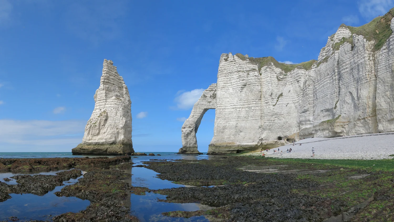
Look through the opening in the chalk rather than at its crown. In Jörg Braukmann's photograph from Étretat in Normandy, the sky and water touch at the back of a hole in the rock. To the left of the opening is the Aiguille, a tall chalk stack with air all around its upper part. The arch carries rock across one opening; the stack has no such bridge to the headland. From another angle the gap around the stack could seem much smaller. The picture is unusually good at making two different shapes legible from one place.
The resemblance between the two forms can invite an overconfident sequence: here is a piece of rock with an opening, here is another one after it has fallen, so one tells the complete history of the other. That is too much to ask of one picture. The photograph shows the connection that remains and the space around the isolated stack. Explaining when particular parts of shore changed and which processes did the work would require other evidence. Seen this way, the pale forms invite questions without having to provide their own dates.
Chalk is an invitingly incomplete explanation
The French geological survey, BRGM, uses Étretat in an explanation of cliff erosion along the Normandy coast. It points out that the chalk varies and that the foot of the cliff at Étretat includes more resistant material than some other reaches of the coast. That makes chalk a beginning rather than a complete explanation of shape and rate. A broad geological label can join places that wear down differently. Bands, weak points and differences in exposure can matter within a reach that appears to be uniformly light in colour.
This is visible as a question before it is visible as an answer. A pale cliff with dark bands can look like a clean diagram in good light. A dark line might be a band in the rock, a shadow on a ledge or wet material. A fracture can be evident in one place and almost invisible farther along the same face. Place the photograph next to a geological description of the coast before connecting every visible line to a particular material. The rock has features beyond what a sunny, distant image can establish.
On the other hand, it is not necessary to turn an arch into a purely abstract problem. The height of the opening, position of the headland and contact with the water all draw attention to where material has survived. A resistant portion may hold a shape while weaker material wears or fails nearby. That relation has more explanatory value than the statement that the whole coast happens to be chalk. To understand a shape, follow the differences within it.
The sea and the top of a cliff can work on it at once
BRGM discusses both wave action at the foot and processes acting from the landward and upper surface. Its account includes water entering or running over rock, freezing and thawing, and the effects of gravity. Those processes need not be imagined as separate chapters that occur one after the other. A cliff can be undercut low down while material elsewhere is affected by weather or by the angle at which its weaknesses lie. How these influences combine depends on the local face and its history.
A simple drawing can help keep the influences apart. Put the foot of the cliff at one end of a cross-section and its top at the other. Mark where water from the sea can reach and where water from the land surface could enter a fracture. The arrows are hypotheses about influence, not proof of movement on a particular day. To find out more, compare observations over time. A rock face still standing today does not reveal the exact point at which the conditions for its next change will be reached.
The distinction also explains why slow is not another word for constant. A coast can show little detectable change for a long interval and a clear change following a collapse. A reported average concerns a stretch, period and method of measurement. It cannot tell a reader that one chosen part of the Porte d’Aval loses exactly that much chalk each year. An appealing numerical comparison loses its value if it moves away from the stretch of coast it describes.
The size of the beach changes the apparent base
Wave height is not the only reason the view from a beach changes. The water level, the surface exposed near the base of the cliffs and the camera's distance from the arch can all change what a photograph reveals. In Braukmann's photograph, pools and dark surfaces spread in front of the pale rock. A picture made while more of that foreground is under water would pull attention away from the base and towards the arch and skyline. The underlying shapes might be little changed, even if the coastline appears to be drawn in completely different places.
That is a useful reason to be precise about the word shoreline. On a particular photograph it might mean the visible edge of the water at the moment the shutter opened. In a survey it can mean a consistently defined feature picked as a reference. The edge of the cliff at the top, the foot of the cliff and a wet edge on the foreshore are not the same line. The one that moves most between two holiday photographs need not be the marker a geologist chooses to assess longer term retreat.
Nor is a photo of the lower shore a guide to reaching it. The rock, tide and access arrangements at a specific time need current local information. Here the exposed foreground is evidence about the picture's composition and what parts of the formations can be seen. It makes the arch and stack look as if they occupy a single continuous scene. It does not determine where it is safe or permitted to walk.
How a useful comparison keeps its viewpoint
An old photograph of Étretat and a new one can be lined up by the familiar outline of the chalk. That might identify the same headland. It does not necessarily make the outlines comparable at a fine scale. A small change in viewpoint changes how one edge lies in front of another. If a stack overlaps an arch in the old photograph but appears separate in the new one, shifting viewpoint is among the explanations to check before claiming the rock moved.
BRGM describes using repeated surveys to observe cliff change and fracturing. Repetition earns its value from observing comparable features. Known viewpoints, measurements or well matched three-dimensional surveys can reduce uncertainty about perspective. The resulting record may show a local failure, a change at the foot of a cliff or little difference within the limits of a measurement. None needs to be embellished by extrapolating a spectacular rate to the coast as a whole.
For a reading exercise, pick a substantial feature present in both pictures and label the two camera positions if available. Then mark which edge of the arch is closest to each camera, and what is visible behind it. If a figure uses the same outline for pictures from opposite directions, a reader can expect apparent changes in overlap. The relative positions of stack and cliff matter to what a viewer sees, just as the actual shapes matter to what is there.
Comparisons can also work on a larger unit than a single named form. An account of the line of cliff between two headlands might compare many profiles along the coast. A profile across one recess could register a strong retreat while another just around the bend shows much less. Averaging those changes is useful for some purposes, provided the endpoints and the uncertainty are reported. It is not an argument that each part of the shoreline moved the resulting average distance.
On the photograph, the broad white faces provide a large enough area for the eye to compare exposed surfaces beside the two named forms. The exposed foreground includes pools, a reminder that a change in the position of a water line can happen on a far shorter interval than the changes a survey seeks to establish. A careful caption supplies the date and viewpoint and leaves measurements to the record that obtained them.
Two shapes, two opportunities to ask what is attached
Both the arch and the Aiguille are recognisable at a glance. The arch has a span connected to a headland. The stack is conspicuous in the view partly because its silhouette is surrounded by sky and water. The eye can read the connectedness immediately. Establishing geological history is a slower form of work: locate the rock, examine the fractures, compare surveys and keep track of whatever is hidden during a particular view.
That difference is part of the pleasure of looking at Étretat. A clear picture gives two forms an exceptional clarity without making them timeless. The shoreline is not required to change fast enough for a human observer to notice while standing there. It needs only to have a history whose results are still visible. The opening gives the eye a place to begin; the survey and geology give it some useful ways to continue.