The Land That Rises at Kvarken
Low ridges in a Finnish archipelago were left by ice. The land’s continuing rise changes which parts of those older shapes lie under water and which pieces become shore.
In this story 6 sections
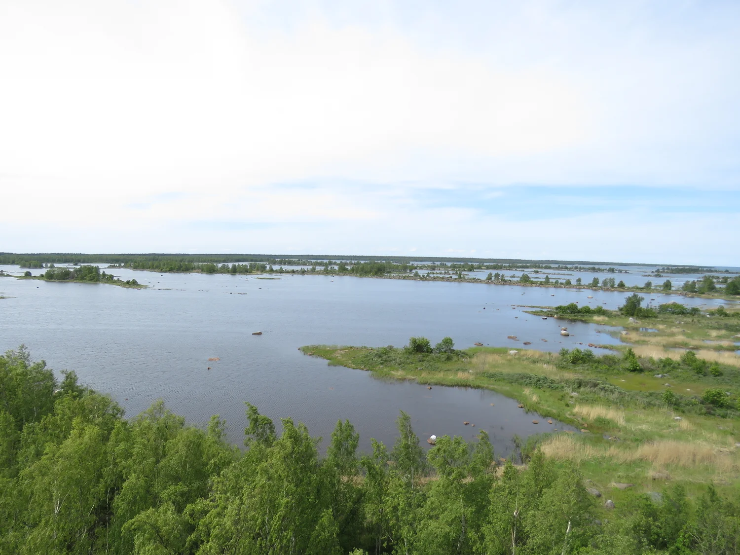
Between the trees at the bottom of Xepheid’s photograph and the horizon, the water appears and disappears in strips. A green point reaches into a broad opening. Farther back there are smaller-looking patches of land with water on more than one side. The view is from Svedjehamn in the Kvarken Archipelago, on the Finnish side of the Gulf of Bothnia. The photo record identifies some of the ridges in the landscape as De Geer moraines. They are older than the present boundary between water and land. In this part of the coast the relationship between the two continues to change.
Think of the scene as having two histories. Ice helped leave the shape under the view. Since the great weight of that ice was removed, the land has been rising. A ridge does not have to grow today for more of it to stand above water tomorrow. The condition that makes it an island, the edge of a marsh or part of a longer peninsula depends on how the surrounding levels meet. This is why a field of small shapes can tell a story whose vertical movement is not readily visible from any site overlooking it.
Some relief was already there under the shallow sea
A moraine is a landform made of material associated with a glacier. At Kvarken, the World Heritage description identifies De Geer moraines among the distinctive formations left by the ice. They can present themselves as repeated low ridges, giving part of the archipelago a washboard quality when viewed from above. The pattern can be clearer on a map or a broad high view than from a spot on one of the ridges. From a single low position it may be difficult to distinguish a narrow arm that continues beyond the trees from a separate raised area with water on both sides.
Rather than making an exact count in the photograph, try following the spaces between the ridges. A dip can hold water or form part of a channel. Its existence as a low area does not depend on being wet in this view. The photograph records where cover, ground and water met on one day, with green plants making parts of the relief more obvious and concealing others. The glacier's contribution becomes easier to appreciate if you picture the same ground under a different water level before assigning a permanent name to every land shape.
An example makes the distinction sharper. Suppose a narrow ridge sits partly below water along its entire length except at each of two high spots. On a map those spots might be islands. Raise the land uniformly a small amount relative to the water and a middle part of that ridge may connect them. The map now shows one island, though no fresh barrier of sediment had to be deposited between the two for the connection to happen. The new outline resulted from exposing more of a shape that was already there. Erosion, deposition and plants can affect it too; this example isolates what a change of level can do.
The land responds after losing a load
Ice once covered much of northern Europe. A very thick mass of ice bears down on the land beneath it. The solid Earth responds over long periods, with deformation extending well below the ground a person can see. Removing the load does not produce an immediate return to a prior shape. The continuing adjustment after the retreat of the ice is described as glacial isostatic adjustment; uplift is the rising component visible in places such as Kvarken. It is not another name for ice still growing across today's archipelago.
The word relative is useful whenever someone describes a coast by saying that the sea is falling or land is rising. A person standing on the shore encounters the result of both land and water levels. A measurement from stable references can help identify the motion of the ground. Water levels have changes of their own. The existence of an emerging ridge in the Gulf of Bothnia would not justify a claim that average world sea level is moving downward. The observation and the mechanism concern this region and the balance of changes operating in it.
Look at the nearest green land and imagine it changing height by an amount that would be difficult to mark on the trunk of one tree over a short visit. In shallow water, very little difference in elevation can separate a long exposed strip from a long covered one. If a 100-metre length of shore in an invented example rises just ten centimetres across that horizontal distance, the abstract slope is one in a thousand. A ten-centimetre change in relative level along that ideal surface would move the intersection by a hundred metres. That is geometry, not a measured slope or a forecast for Svedjehamn. It shows why gradual vertical change matters particularly in broad shallows.
A bay acquires an increasingly narrow exchange
The Finnish land and waters agency, Metsähallitus, describes coastal lagoons shaped by postglacial uplift, including formations known as flads and gloes. One way to understand them is to ask how readily water moves between a hollow and the surrounding sea. A bay with a wide opening permits exchange in a different way from a hollow separated by a shallow threshold. If the threshold becomes shallower relative to the sea, the passage can narrow or cease to carry regular exchange. The water body on the inside may persist. It has changed its relationship to its neighbour.
The transition is more interesting than a change of colour on a map. The frequency and conditions under which water passes can matter to the environment inside the hollow. A thin line suggesting a sea connection may cover several possibilities, from regular exchange to an occasional event at higher water. No single frame taken from above can certify how often those possibilities occur. A shoreline's position today and a classification of conditions over time are different records, even though they concern the same inlet.
There are effects in both directions on life close to the shore. Newly exposed ground can become available to plants, and changes in exchange can alter the mix of conditions in the remaining water. What develops depends on the site. It is fair to describe emergence as giving new shapes a set of opportunities, rather than assuming every shallow inlet progresses through the same stages at exactly the same rate. The documented variety across the archipelago is part of what makes a visit to one photographed patch an introduction rather than a full inventory.
Across the gulf, the same response looks different
UNESCO includes Kvarken and Sweden’s High Coast in a single World Heritage property. The Swedish shore and the Finnish archipelago are not expected to show the same topography. The Finnish landforms in this view are low and spread over shallow water. On the High Coast steeper terrain gives a stronger visual sense of height. Older shore traces can lie above the present waterline. Read next to evidence of modern relative change across the gulf, those forms give a longer context for a process difficult to see during one lifetime, let alone from one viewing tower.
The difference makes the pair of sites informative. A high former shoreline can emphasize the vertical component of change. A low island shore can make the horizontal part striking on a map. A steep wall could rise the same amount as a very flat patch and produce a much smaller change in the width of exposed land. Keeping the shapes and the process distinct explains why contrasting views can belong to the same geological account.
Match the dates on the maps
An older shoreline map and a newer one could help reveal some changes, but read the legends before laying one over the other. A line based on one water level and a line surveyed after a period of high water need not match, even in the absence of any enduring change. Likewise, a coarse map can round the points that a larger-scale chart shows as separate islands or narrow passages. Find a few fixed references inland and check which small differences are actually visible at both scales.
The comparison is strongest when it is backed by measurements appropriate to a gradual process. A dated photograph is useful for recording which areas were exposed on a particular day. A series of level measurements tells something else about the direction in which land or water has been moving. Each piece of evidence improves the other if its limits are kept explicit.
Keep the old ridge in the new shoreline
The scene in the photograph is a good starting point because its land does not stand in one continuous wall against the sea. Several projections and separated shapes invite the eye to ask what is just below water. The moraine ridges supply one reason a shallow change can affect more than the outermost line of the coast. A narrow connection can appear or disappear while the larger pattern of alternating raised and low ground remains recognizable around it.
Return to the water between two green shapes. The ice is no longer there, but some of the ground it left is. The coast looks as it does today because the shapes meet water at particular heights. A later outline can be quite different without giving up that inheritance. In Kvarken, a consequence of the distant disappearance of ice is still taking ordinary forms in the present: a new strip of ground, a smaller opening or a piece of shore that stops being an island.