The Lake Above the Panama Canal
Gatun Lake forms part of the Panama Canal’s route and supplies water for its locks. A map of the passage makes more sense when you draw it from the side.
In this story 4 sections
On an ordinary map, ships take a route linking the Atlantic entrance of the Panama Canal to the Pacific. The page does not need to show how high a ship will float at any place along the way. It can be useful for location while encouraging a misleading picture of a ditch at roughly sea level for the whole distance. The canal uses a lake well above the seas at its entrances. A ship has to become a visitor to that higher body of water and leave it by way of another controlled change in level. The canal is as much a route drawn up and down as it is one drawn across.
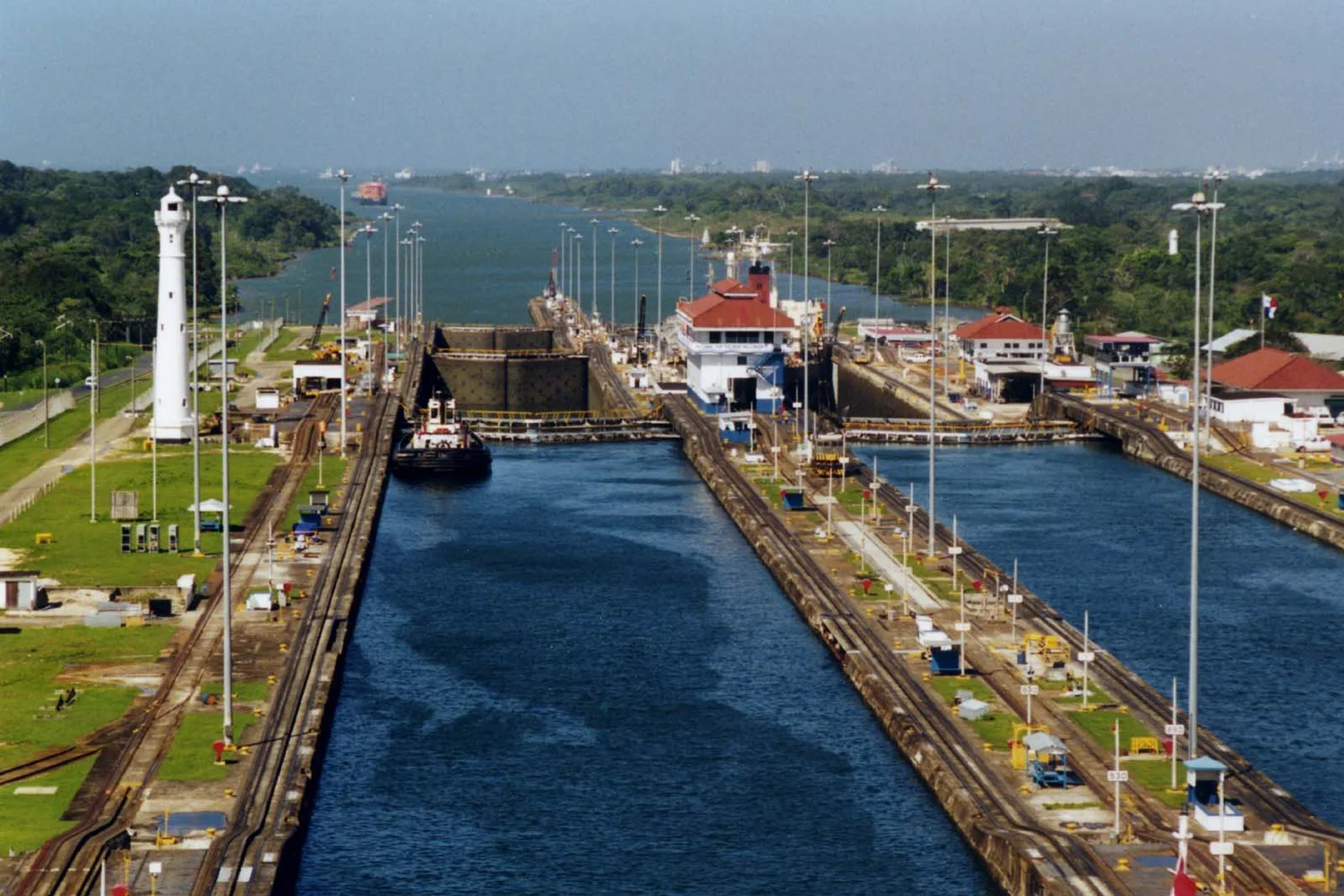
The Panama Canal Authority identifies Gatun Lake as a navigated part of the route and as a source of water for the locks. This double use helps explain something surprising about the photograph from the original Gatun Locks. There are other stretches of water elsewhere in the canal, and a crew taking a ship through the system sees them as parts of a journey. The lake can appear as one of those stretches and as a supply for making part of the journey possible. A profile of elevations and a drawing of water movement give those two ways of seeing it their own lines.
Two kinds of water movement meet a ship
On a rough cross-section, put an entrance near sea level at each end. In the middle mark the elevated part of the route at the lake. The canal authority gives a representative height on the order of 26 meters above sea level. The sketch is a way of understanding the broad lift, not a way to predict an individual gate’s available level. Ship movements can differ, and real water levels vary. A broad line across the page can show the traveler gaining height and losing it again before you have chosen how to represent individual locks.
A lock chamber has something in common with two bodies of water that can be connected and separated under control. A ship floats in the chamber. Change the level of the water around it and the ship changes height with the water. Once the appropriate difference in water level across a gate has been removed and the movement is authorized, a route at the different level can be made available. You do not have to imagine a machine grasping the ship and carrying it into the air. For the passage, the floating relationship is maintained. The change is in the support below it.
That is a slightly different story from what happens to the water. A ship rising in the canal can do so as water from a higher supply enters a chamber. The authority describes gravity as supplying flow in the system. The ship goes up while water is moving to a lower available level. A descent can involve water being released toward a lower level. From the side of the canal a visitor might naturally use the ship’s movement as an arrow for everything else going on. Draw the path of the vessel and a path of water separately before comparing them.
A few steps make space for a lot of movement
Notice how little a photograph through one chamber says about the full ascent. Gatun Locks, at the Atlantic side of the original arrangement, provide a sequence of chambers and controlled level changes. Seen from one view, an intermediate level can give a person a smooth foreground to look across. That does not establish what happened behind the preceding gate or how far the route still has to rise. Add the order of the chambers to the profile before trying to read the amount of movement from the apparent size of one step in perspective.
Imagine a demonstration with two chambers rather than the specific proportions of the route. In the first, the ship goes up from the lower entrance to an intermediate level. It passes to the second when the difference is managed. The second raises it again. A visitor might describe the two enclosed spaces as empty whenever there is no ship in either. In the water account, a chamber has a meaningful volume and level even while its mooring area is unoccupied. It can contain water relevant to the next operation. Calling it empty gives the word a meaning useful to a scheduler, and one quite misleading for a water ledger.
There is also no requirement that a ship’s own journey use the original locks shown in the picture. The expanded system adds other locks with different features. The authority’s description of the expansion covers basins that can hold and reuse some water as part of operations in the newer design. The important thing for a general sketch is to avoid assigning a feature seen on one side of an illustration to every structure of the same name. Both arrangements serve a route with an elevated body of water. The way they handle the water can differ in notable ways.
Keep a ledger for water as well as a map for ships
Gatun Lake is a reservoir within a watershed. It does not receive a full new lake at the beginning of each day. The authority’s public material discusses the supply as a resource for the canal and for furnishing drinking water. The words “used by the canal” therefore do not describe the only thing the water has to do. One part can be needed at a different time or under a different set of conditions from another. Rainfall, river contributions and available storage all matter. For a photograph of a ship on a broad expanse of water, the surrounding area that supplies it is likely to be almost entirely out of view.
Make a simple diagram with an input, a store and several outputs. Put “inflow over time” on the left, “reservoir level and water stored” in the middle and “releases and other uses” on the right. The quantities on the three lines are related, but they need careful measuring and labels. The level is a height. The amount of water stored is a volume related to the shape of the lake. A release can be expressed as a volume during an interval or a rate. Subtracting a label given in meters from a number of ships tells you nothing about use. Even comparing volumes requires a common period and a definition of which water the report counted.
For this reason a single figure for water used per transit rarely tells as much as its apparent precision promises. Which route and design does it refer to? In what period was the figure measured or estimated? Is it for a particular vessel, an average of movements or a defined operation? How is water that is saved, transferred or used for other purposes accounted for? These questions are useful even for a reader with no intention of working at the canal. They prevent a number about one practice from becoming a universal property of every crossing.
A separate drawing of the watershed can start outside the photograph, with rain and streams that carry water toward the reservoir. Treat spills and controlled releases separately from the voyage of any one ship. One approach to looking at a report is to compare conditions at the start of a period with those at its end and then see which inputs and outputs have been counted between them. A year with much inflow does not tell you by itself what could be used during the driest part of it.
This is why an engineering profile and a rainfall chart will never make interchangeable accompaniments to a story about the canal. The profile shows the sequence of heights a vessel must negotiate at any time it traverses the system. The chart and a related reservoir record can give context for how much latitude there was about handling water at a particular time. Both drawings are about the lake, but each is a map of its own kind of constraint.
A view returns to its true size
Go back to the high view of the locks. First follow water boundaries and the long straight lines that give them form. Then mentally place the lake behind the movements available to a vessel. The two images now share a cause without becoming the same drawing. In the photograph the waiting spaces and gates show a way to organize passage through a managed change in height. In the larger picture the country’s freshwater and storage make the series of operations possible in a setting crossed by ships.
Look lastly at the small space that seems to separate the decks of vessels from a bank. At one moment a ship’s relationship to the nearest ground may give a clear visual clue to what has changed. At the scale of the whole trip, the same clue can get lost entirely in a line showing ocean to ocean passage. Keeping a simple side view next to the map restores a piece of geography that both matters greatly and would otherwise be extremely easy to leave out. The route passes through a lake rather than merely past one, and uses the water it floats on in more than one way.