The High Ground of the Cairngorms
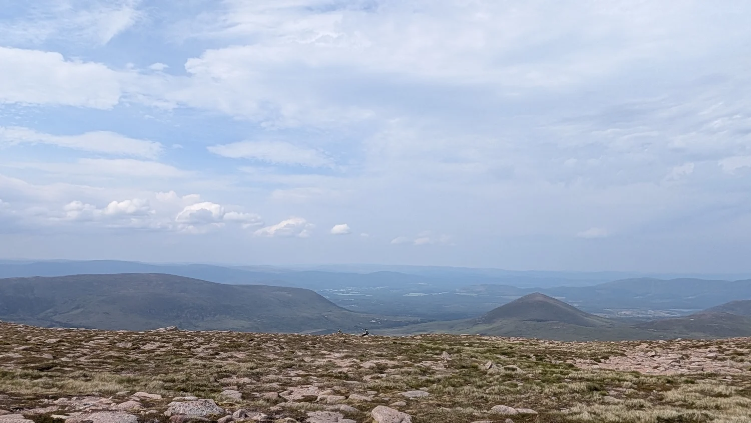
A photograph from below Braeriach shows why height and steepness are different things. Scotland’s Cairngorms preserve broad upland surfaces alongside valleys and hollows shaped by ice.
In this story 5 sections
There is a large amount of sky and a low line of rock in the photograph from below the summit of Braeriach. The foreground does not look particularly high. Without something to compare it with, a wide strip of stony ground can appear nearly flat and quite ordinary. Look farther across. Lower land sits below the foreground, and another broad outline lies against the sky. Height becomes visible through the relation between parts of the same view, rather than through a single peak.
That is a useful introduction to the Cairngorms, a group of mountains in Scotland. The name suggests summits, but the distinctive geographic feature is much more extensive than the highest points. NatureScot's character assessment describes broad high plateaux, rounded summits, rocky edges and deep valleys and corries. They fit together in the same landscape. A map which has room only for the highest peak and the road nearest it would leave much of this geography out.
Separate how high the ground is from how fast it rises
Picture a sketch with the height on the vertical axis and the distance along a line on the horizontal one. A long segment can be quite high even if the line hardly rises from one end of it to the other. A much lower segment can be steep. What the first describes is elevation. What the second describes is change in elevation over distance. Confusing them makes it easy to overlook the broad surface once the journey to it has stopped climbing sharply.
A contour map supplies both quantities in a compact way. Numbers on contour lines show elevation. The closeness of their spacing points to a steeper slope, provided the map scale and contour interval are understood. Contours spreading out at high elevations can indicate gently sloping ground far above a valley. Contours packed closely below it can mark a steep margin. The lines do not imply the high area is level like a floor. They show why the change in slope may be more informative than the point of greatest height.
The photograph of the plateau makes the same difference in a quieter way. The nearby rocks occupy a thin, shallow part of the image. Ground going into the distance provides a wider horizontal scale than a view looking straight up from the valley. That impression depends on viewpoint. A photographer lower down could show the same massif as a wall. Neither view is a measurement. Looking at them together would be a better way to picture the relation between the high surface and its edges.
Two kinds of old shapes meet here
The landscape assessment explains that granite underlies the massif and that some landforms are inherited from before the last glaciation. The point is not that the high country has lain untouched since that time. It is that subsequent ice and weather worked on an existing relief, and did not leave all its parts the same. Some rounded forms and broad surfaces survive beside places where ice cut much more deeply. A view across both lets the reader see evidence of continuity as well as removal.
The park authority's material on glaciated landscapes gives examples of deep valleys and breaches, including the Lairig Ghru, and also describes gentler remnants of earlier upland forms. A breach can make more sense to a map reader who keeps the high ground in view. It is a gap through the larger upland form, rather than a completely separate object. Following the line of such a valley shows how a landscape that looks like a set of isolated peaks from a road can be understood as a high mass partly cut apart.
The fact that granite underlies the area does not explain every visible feature by itself. A rock type gives the story a material. Where the material stood, how it was weathered, where ice moved and which edges were cut or preserved are separate questions. The broad foreground of a photograph shows the result. It cannot establish the date or mechanism of each individual patch of bare rock. Those more precise claims need other evidence.
A hollow can belong to the edge of a plateau
The word corrie is useful for a visitor looking at a deep hollow with steep sides in Scottish mountains. On a sheet of contours, rings and arcs that curve around one another can help identify the broad form, while tightly packed sections point to steeper parts. In the Cairngorms these hollows can interrupt what otherwise reads as a continuous stretch of high country. Looking only at the top of the high ground leaves out the curvature that shapes the way it drops away.
A profile can show this with very little detail. First choose a line that follows the high surface. Then choose another that crosses a steep hollow. Both may start at a similar elevation. The first may look like a long sweep, the second like a plunge and climb. Moving the beginning by a short distance can drastically change the reported profile, so any sketch should keep its line marked on the plan. Without that line the reader has no way of knowing which question the section answers.
The same exercise works with a tor. This upstanding mass of rock is much smaller than the whole plateau. NatureScot notes distinctive examples on some high ground, and the park material names examples elsewhere in the Cairngorms. If you choose a section merely to intersect a tor, it can look unusually rough. Move it to the side and it might miss the feature. Neither profile should become shorthand for every part of the upland. A natural landscape does not export neatly at one scale.
A shallow valley can channel a stream across high ground while looking quite different from a deep trough below it. Both may put blue lines on the map. The blue alone says little about the form of the ground either side. The park authority contrasts gentler upland valleys, such as those around the Feith Buidhe and Caochan Dubh, with the deeper, steep sided glens that cut through the earlier upland relief. A comparison at the same map scale makes these differences easier to see. At changing scales a narrow marked line can seem important merely because the cartographer enlarged the part of the massif that contains it.
The contrast is also useful when two maps present the height in different ways. One map may use an interval of ten metres; another may mark every fifty. At the same distance, the first can show many more crossings of contours without implying a steeper landscape. Read the interval before comparing the lines. An upland that seems empty of marks on one map can resolve into small slopes and hollows on another. The line density tells you something only when you know what each line measures.
Surface cover has a scale of its own
The view from near Braeriach shows a stony foreground. It makes an abrupt contrast with the word plateau, which can suggest a smooth slab to someone who is only thinking about its shape from a distance. A gentle overall slope can still have a rough surface. NatureScot describes stone, gravel and low vegetation in the high landscape and describes the character of the summit environments as exposed. Those are physical conditions that cannot be inferred from the space between a pair of contours alone.
Nor can the visible rocks tell you how easy a particular walk will be. A narrow route can leave the high surface and encounter changes that are not visible in a photograph of another direction. Weather and the available path are separate from the geological explanation of the land. The useful comparison here is between the sizes of features. A shallow path in a foreground may matter immediately to a walker. A long plateau may matter to a person asking how the massif is arranged. Each can be the proper centre of a map at its own scale.
Even the word open shifts meaning. A wide view can make the ground appear open because there are no tall trees in front of the camera. Visibility on an actual day is another matter, and a broad surface can have few obvious landmarks near the person standing on it. The fact that a landscape looks easy to grasp in a panorama should not be taken as trip advice. The shape of a landform and the ease of finding one's way across it are distinct questions.
Give the high ground room on the map
One useful way to study the Cairngorms is to mark a broad area of high ground rather than ring each summit individually. Then trace the deeper route of a named glen or breach and compare the two. If a map carries a shaded layer for elevation, inspect what gets joined or broken apart when the boundary for high ground is moved. It will be clear that any such boundary is a tool for the reader. It is not a thin stripe on the grass.
Now return to the photograph. The broad ground near the camera shows an impression of the upland surface, while the layers farther away suggest why a whole section cannot be inferred from one frame. The photograph does not need a prominent summit to explain a mountain landscape. Stand on one of its high surfaces, or look carefully at a picture made there, and the eye begins to ask where that surface continues, where it has been divided and how far down a valley lies. The massif becomes something with a shape between its summits.