The Fissures Between the Plates
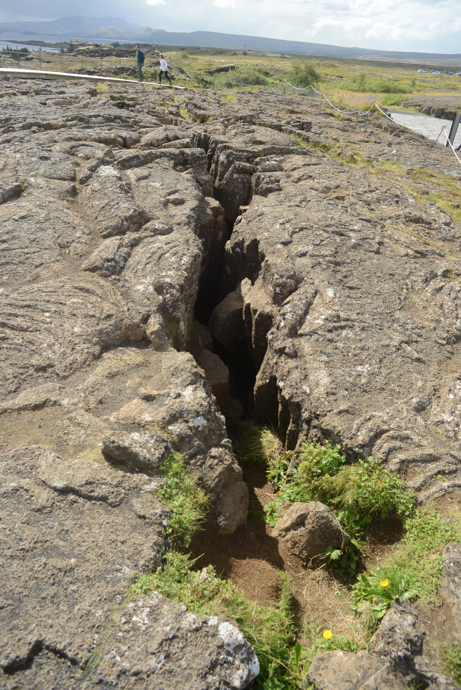
Almannagjá is one of the easiest fissures to see at Þingvellir. It is an entrance to a picture that takes in a broad and active rift valley.
In this story 4 sections
The rock near a fissure in Iceland’s Þingvellir National Park can look like the side of a torn piece of paper. There is a great deal of dark material on one side of the view. A gap offers the sky or ground a different route through it. The other side may look close enough for the two walls to be imagined as the two edges of a clean break. What the camera cannot show at this scale is how many other fractures and changes of level participate in the story. One of the most recognizable views of a plate boundary on land needs more than the length of space inside the frame.
Almannagjá lies within the landscape where the national park presents the Mid-Atlantic Ridge and the rifting of Iceland’s crust. The park gives accounts of a rift valley, faults and fissures. That is usefully different from the simplification that the meeting of plates is completely contained in the small distance from one side of a walking route to the other. A diagram of the region can recognize that motion is distributed across a belt. A view along one marked fissure can still be one of the best places to begin examining what the motion has made possible.
Change scale without changing the subject
Start with the northern Atlantic on a map small enough to hold the coastlines on both sides. Iceland occupies a place along the great ridge system. On paper a cartographer may set a line down its middle because a line can stay legible even on a very small illustration. A few centimeters higher on the page there may be a legend showing which symbols identify plate boundaries. At this scale it would be inconvenient to include every fault, and readers will probably not mistake each stroke for a trench they can go and inspect.
At the scale of the park the choice of line matters more. You can mark specific features by name. Some lineaments are easier to follow on a map or aerial image than on a route at ground level. A scarp seen from below can feel like the only feature there is. A broad view can reveal that other breaks lie in parallel or at an angle elsewhere toward the lake and opposite side of the valley. Where you stand can govern the amount of structure you see. This is the first reason a map of a place has a different task from a thumbnail of continental geometry.
At the closest scale, watch where the surface on either side is situated in height. The word fissure puts the opening in the foreground. In looking at a faulted landscape, relative vertical movement can be significant as well. Using a ledge to compare elevations is more helpful when you have some basis for tying it to material on the other side. Two striking ledges are not automatically remnants of an originally level layer. The shapes are worth drawing without assuming the drawing tells the whole story of when and how they came apart.
A floor can move differently from the edges
An illustration of a rift valley often contains a zone that has dropped relative to its sides as the crust extends. That is a more practical picture for Þingvellir than the idea of two massive flat blocks simply gliding away at identical height. Small parts of the valley are separated by faults. Motion may accumulate across them over intervals that a visit cannot reveal. Despite the narrowness of one opening, the land around it has recorded an overall relationship that extends well beyond the place where a person can see a pair of walls.
Make a paper model if the directions are hard to keep straight. Sketch two edges and a stripe down the middle. Give the stripe a slightly lower level on a cross-section. Divide the surfaces with a few sloped lines to represent possible breaks. The point of the model is that increasing the distance across the system can coexist with a drop in some of its middle parts. It is not a scale drawing of any named fault. Put a label at the difference: what are you showing for extension, and what are you showing for relative height? A single long arrow could be useful in a plate diagram and useless for making that distinction.
The park associates the area with a volcanic and fissure belt. That adds another history to the picture. Lava can make the surface on which later cracks develop, and different events can contribute different materials to the present landscape. The dark rock in a photograph is a real part of that setting. Its age, thickness or origin deserves evidence beyond a general association with volcanoes. If a park interpretation identifies a layer or a dated event, keep that identification attached to where it was observed. A landscape can look remarkably uniform while its local histories differ.
Write down what a still image can't date
The instant of a photograph is poorly matched to the rate of regional geological processes. It may show an obvious opening and no visible motion. This is normal. A considerable difference observed today can have been accumulated over a long period, or include discrete episodes within that period. One should not convert a reported rate of plate motion into the number of years needed to produce one visible gap by simple division. The full motion may not occur at that single opening, and its present shape need not be an uncomplicated trace of only one measurable process.
Use a dated account of movement if movement is the question. A park description can record the regional context; researchers can compare measurements across a much wider network than a single rock wall. Distinguish where a measured distance starts and ends. An observation from inside one fissure and a regional measurement of relative plate motion can both be useful, but trying to make one exactly match the other is a poor test of the underlying geology. Keep the scales separate and bring them together only where the relationship is justified.
There is also work that water and weather do long after rock is first exposed. An opening can provide a route for drainage or collect material. Freeze and thaw, erosion and fallen rock can add edges to the view. The size of a feature seen from a narrow turn in a path is partly a feature of what the observer can see. If you compare photos from two dates, establish a reliable fixed point before attributing a changing edge to geological movement. A new path or viewpoint can offer a reason for apparently larger gaps without requiring a single motion in the cliff.
A topographic map provides something intermediate between the photograph and the small plate diagram. Follow an imagined traverse perpendicular to the long axis of the valley. Note where contour lines bunch up, where they spread out and where a survey has left a stretch of water rather than ground elevations. Draw a small cross-section through the same positions. A cliff in the photograph may now appear as one of several departures from the valley’s general level. A larger feature elsewhere may be invisible from the path at the foot of the first cliff.
Repeat the traverse a short distance away on the map. The central parts may have a comparable broad relationship, while the exact count of sharp edges changes. Neither traverse is a constant description of every possible crossing. Between the two you have enough information to begin asking which relationships persist and which are features of a particular position.
Another map of the valley
The area holds much more than a vivid demonstration of geology. UNESCO identifies the place with Iceland’s Alþing, the historical assembly that met in this setting from around 930 to 1798. The valley contains evidence of the people and activities that belonged to those meetings. Its shape is part of the historic site’s geographical context. It does not explain the assembly by itself. A map tracking footsteps or the remains of booths needs distinctions that a tectonic diagram was never meant to provide.
Picture someone arriving for an assembly from a distant place. The route to an open area and the edges visible from it would have been parts of the journey. The same wall that looks to a geologist like evidence from a structural boundary could be a permanent orientation point for somebody with other things to think about. It is reasonable to hold these uses side by side when reading a view. We need not assign a unique political meaning to any geological feature in order to recognize that people acted in a very particular landscape.
Before leaving the photograph, count the things that do not fit into a bare drawing of a crack: the layers, the slope of the visible ground, the surrounding landscape and the human route from which you might look. Now return to a broad map. It will make room for the other breaks in a region whose geology cannot be compressed into two sides of one view. At Þingvellir one small viewpoint does a worthwhile thing. It lets a person notice the difficulty of drawing that much larger line.