The Fiord Behind Milford Sound
Piopiotahi is a valley full of sea. Its glacial walls continue below the glittering water, where rain and runoff change what lives at relatively shallow depths.
In this story 5 sections
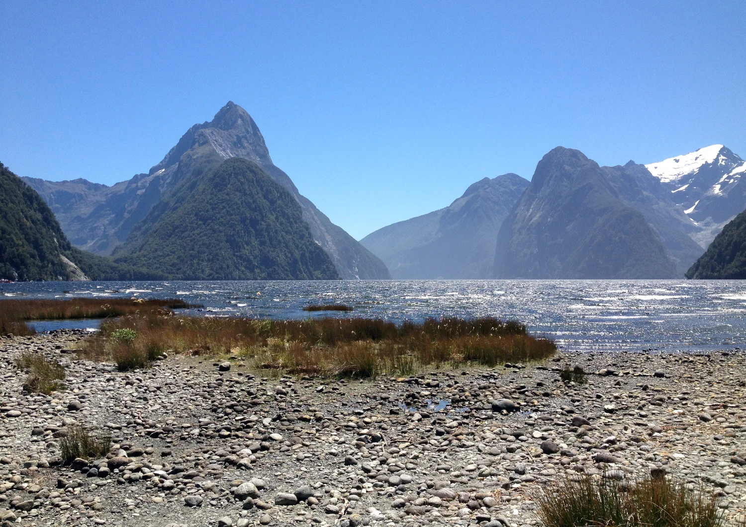
Across the stones in MurielBendel’s photograph runs a slender line where the land is wet enough to reflect a little light. Beyond it is a wide strip of water. Mitre Peak stands to the left, and slopes are visible at the back and toward the right. It is easy to scan the skyline first and then leave the water as a strip at the bottom of the view. The water could be much deeper close to the rocky sides of the inlet than that band of reflected light would lead anyone to suppose. Most of the valley isn't shown at all.
Piopiotahi, or Milford Sound, lies on the southwestern coast of New Zealand's South Island. Despite the English name, the form beneath the water is a fiord. Glaciers opened and deepened the valley before the sea filled it. The rock walls that give the photograph its vertical scale continue below the surface. There are therefore two adjacent questions to ask. How did a deep valley come to be open to the sea? And how does water in such a setting differ from water at the same depth farther out on the coast? The connection between those questions begins above the shore and reaches down into the dark.
Two valleys meet at the edge of the water
It helps to draw an imaginary cross section through the fiord. Begin at a height somewhere on one slope, lower a line to the water and carry it down the bedrock until the bottom turns toward the other side. The parts above the surface appear in a photograph. The water cuts them off visually at a near-horizontal level, and perspectives from the shore can make their bases seem to rest on that line. The rock has other ideas. A view that continues the line down shows the water filling space once occupied by part of a glacial valley.
The Department of Conservation describes U-shaped valleys among the landforms glaciers cut in Fiordland. The distinction is visible in an idealized section: a mountain stream may concentrate much of its work near a narrow bed, while thick moving ice can fill a wider section and contact the sides as well as the bottom. The valley left behind can have steep sides and a broader trough. An actual cross section depends on the geology and history of that piece of ground. It need not reproduce a perfectly rounded letter. The term helps show what scale of landform to inspect.
The shoreline also has deposits in some places. The foreground of the picture shows loose material that invites a person to imagine a gradual descent continuing very far out under the water. A flat area near the head of a fiord can be quite unlike the wall farther along the side. Sediment spreads where streams or other local flows lose enough energy for it to settle. Neither a gentle margin in one view nor an abrupt bluff at another site can describe the whole inlet. Each completes a part of the line through land and water.
A glacier leaves room for the sea
A glacier can move rock material across a bed and scrape it against what it passes. Ice can also pick up pieces from fractured rock. Given enough time and ice moving through the same valley, such processes can deepen and reshape the route. The landscape in Fiordland has encountered ice over more than one interval. It is useful to think in terms of work done through long periods while the relation of the ice, land and sea was changing. The waves one might watch today were not responsible for excavating the entire space they reach.
When glaciers retreated and sea level rose, sea water entered the valleys that stood open to it. The position of the coast changed relative to the spaces gouged into the rock. Out past the inlet is the wider sea; inside is a long rocky basin with connections, barriers and depths of its own. In its overview of New Zealand fiords, Te Ara describes shallower barriers near entrances that affect exchange. A sill is a shallow threshold relative to the basin behind it. It need not appear as a wall above water. A boat observing the surface can pass from one setting to another without seeing the point at which the bottom changes character.
A plan of the shoreline tells a person which part of the inlet opens outward. It does not tell them how deep its interior and opening are. A chart of measured depths can add a different line of evidence. In a general fiord cross section a deep basin can be connected to the outer sea over a shallower threshold, with wider or tighter spaces changing the route water can take. Surface continuity alone does not tell whether motion and exchange take place equally at all depths. That difference helps explain why a fiord can be connected to the sea and retain particular conditions inside.
The shallowest water may have arrived from the hills
On a rainy day water runs off steep slopes, enters streams and falls toward the inlet. That water is relatively fresh. Where it spreads over salt water it can form a less dense upper layer instead of immediately making one well-mixed basin. Its thickness and continuity depend on inputs and mixing. It doesn't have to extend so uniformly that a single reading tells the story for the whole site. Rough weather, a flow near a river mouth and conditions farther out can change what a particular patch is like.
The Department of Conservation's account of the marine reserve notes that runoff can bring tannins washed from material on the forested slopes. These contribute to a darker surface layer that limits how much light passes down. The same water thus connects the top of a hillside to the illumination of walls beneath the inlet. It is possible for the surface to send plenty of reflected light toward a camera and for much less light than expected to reach a point a little below it. A view of the points of brightness in the photograph offers no measurement of how clear that water was on the day.
There is a useful distinction between a fresh surface layer and the salt water below. The conditions shift with depth, and so does the habitat. Organisms suited to the upper layer do not automatically represent what lives against a wall beneath it. Water that is dark relatively close to the surface can help make conditions for organisms otherwise seen at greater depths. The photo could have been taken from the same position several times without readily revealing these changes. The mountain above the surface is an easier fixed reference than the invisible boundary between water layers.
Life has a wall to attach to
The reserve account describes black coral and other animals on steep underwater rock, including sponges and animals that grow on or encrust the surface. A sloping or near-vertical wall gives them surfaces to occupy as the conditions change lower down. If the bottom were imagined as one flat floor, much of the area available to such organisms would be overlooked. The geometry supplies more than a pretty backdrop above the water. It continues to give shape to the habitats below. The path of light through the fresher layer helps decide which of those parts will have conditions ordinarily associated with deeper sea.
One should distinguish this picture from what a person might expect to see simply by looking outward from the foot of Mitre Peak. A shaded wall, a stretch of floor and water close to a stream entering the inlet all present different physical settings. It is quite possible to identify an animal in one of them without having a basis to expect it across the whole fiord. Maintaining a meaningful sense of place means keeping the particular wall and depth in view when describing what lives there.
This is one of the pleasures of studying the photograph alongside the conservation account. The photo shows the size and steepness of grounded forms. The description of the reserve connects rock surfaces to distances below the water and to a continuing supply from the hills. It makes visible, in words, a portion of the landscape that a photographed panorama can hint at but cannot really show.
Complete the section in your head
Start at the left of the water in the photograph and follow the rise of Mitre Peak. Then follow the opposite path in imagination, through the edge of the water and toward the deep parts of the fiord. The climb and descent belong to terrain shaped across a far greater span than a day's weather. Now add something moving on a much shorter timescale: rain going down a slope and spreading out above denser sea water. The two processes can be considered together because the shape left by ice is where water and light are moving today.
The word fiord has a useful specificity once a reader can call up that section. It identifies the kind of valley behind the broad strip shining in the picture. The sea has filled it up to a surface that can shine, darken, reflect a summit or catch a little wind. The photograph stops there. Learning how the sides continue below it is what turns a familiar scenic view into a view of an unusual marine place.