The Cloud Bank Below Teide
Tenerife’s sea of clouds takes shape where moist Atlantic air meets rising ground and a warm layer limits how far the cloud can grow.
In this story 5 sections
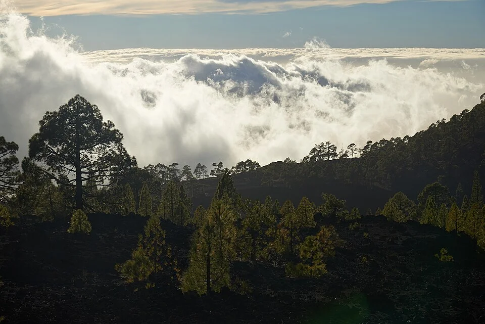
From above, the cloud bank on Tenerife can seem to have settled into a basin. There is apparently a shore where a ridge protrudes, and a nearly level white distance in the place where the coast ought to be. Look again at the trees. If a low part of a slope disappears while a higher line of trees stays clear, the cloud is doing something more legible than hiding the view. It has a top. Someone on the lower road may be standing against its bottom, or somewhere inside it, without knowing how much blue sky there is higher up.
This is a familiar sight on Tenerife, whose ground rises abruptly from the Atlantic to the volcanic landscapes of Teide. Spain’s meteorological agency, AEMET, describes the sea of clouds as a visible sign of a temperature inversion in its technical work on observing conditions. That word explains why a photograph that looks picturesque is also good evidence of an organized atmosphere. It is not an observation of temperature in its own right. It does make it easier to ask where the interesting measurements would be.
First, give the air somewhere to go
Air coming toward the island meets a great lump of terrain. When moist air is forced up a windward slope, it expands as it meets lower pressure and cools. If it cools enough that water vapor reaches saturation, small droplets can form. A slope on which a walker is climbing through fresh air can turn into a slope on which a walker is climbing through a cloud. The vertical movement of the air matters far more than how far a walker has advanced in kilometers along a road.
AEMET discusses prevailing northeasterly trade winds in this setting. The direction helps make sense of cloud on one aspect of the island while another remains comparatively open. On a map, find the outline of the island and draw an arrow toward it from the northeast. The arrow is only a rough helper. It tells you which ground the wind would meet if it came straight in from that direction. It does not predict how the flow bends around a ridge or spills across a saddle. Two places with a similar elevation can therefore be very different places to look for the edge of the cloud.
It is tempting to explain the white bank entirely by evaporation from the sea directly below it. The air often comes with a history. By the time it rises along the island it can have spent hours traveling above water, and the processes that bring it up or keep it level influence what observers see. The visible droplets are newly condensed water at a particular place and time. The water vapor feeding the cloud did not have to leave the ocean just off the nearest beach that afternoon.
The lid that does not look like a lid
In much of the lower atmosphere an ascending parcel of air moves into a colder environment. A temperature inversion is a layer in which the surrounding air becomes warmer with height, over some interval, instead. Imagine moist low air rising and cooling toward an area where the air immediately above is relatively warm and often much drier. That arrangement tends to resist mixing through the layer. The cooler lifted air loses some of the buoyancy it would need to keep rising through it. Cloud that forms below can spread over a considerable area with relatively little vertical growth.
For Tenerife, AEMET describes this alongside sinking air aloft, which is associated with a drier upper layer. Sinking air is compressed and warms. Meanwhile, below the inversion, moist trade wind air encounters the island. The distant flat top of the resulting cloud can tempt you to imagine it has hit a solid barrier. The boundary is entirely air, and air can and does mix across it. On the scale of a landscape view, the stability of the layer makes it possible for the top of the bank to stay recognizably at one level for a time.
You may recognize a seam between the gray photograph taken partway up and the bluish photograph taken higher from the same side of the island. The gray view may contain no recognizable clouds because the camera is in them. The blue view might leave you wondering where the weather went. A person talking to you from the coast may give an altogether different report. There is little contradiction among the three remarks until you attach the same height and place to each.
A top that keeps moving
It is helpful to think in layers without assuming those layers sit at fixed heights. A ridge that interrupts cloud on a cool morning could be inside it later, or there may be no continuous bank when you return. Wind, humidity and the height and strength of the inversion can vary. Lift at the slope and the supply of cloud can also change. In a photograph the bank may have a wonderfully sharp boundary in one direction, then break into loose wisps in a gap just off the frame. A stable atmosphere can still look very busy at its edges.
If you are trying to make sense of that movement from a fixed point, choose a quiet feature at a known place in the scene. A shoulder that you can trace on a map is preferable to a patch of sky of uncertain distance. Watch whether the same part of the shoulder appears and disappears and whether the wisps attached to it seem to draw in the same direction. From a second stop, identify another feature and put the time in your notes. If the cloud changes quickly, those times may matter more than the distance between the stops. A lower photo made much later cannot automatically bracket the base of a bank you saw earlier.
Flat layers observed in one picture need not all belong to a single cloud. High bands can coexist with the low deck. Close cloud can cross the view of a distant clear slope. Separate what lies along the same line of sight from what you can confidently put near the same elevation. Roads with minute, identifiable bends make useful clues when visible, but a gap at a bend alone does not prove the cloud stops there. You may be looking through a temporary hole.
Why the forest changes the picture
A photograph of white cloud alone provides little information about scale. Some nearby trees, including the pines visible in the photograph accompanying this article, help a viewer connect the moving white background to solid rising ground. The trees also make it easy to catch yourself treating the cloud as a flat white object behind a ridge. It may continue between tree-covered shoulders where you cannot see it, or some of the trees in the view may themselves be blowing in scudding droplets. Cloud often makes a landscape look simpler while making it less possible to say exactly what is where.
Teide National Park is a UNESCO World Heritage property. Its volcanic terrain is relevant to this view because the air is crossing an abrupt, complex island with a large amount of relief. In a clear image the ground offers a century-scale story of erosion and volcanic history. In time lapse the clouds offer a story that can change well before you have finished lunch. Both images may have exactly the same frame. There is pleasure in returning to a view long enough to notice how quickly a prominent ridge can alternate between looking like the main fact and looking incidental.
Someone hearing a visitor say that a cloud bank starts at the forest may understand why the two often appear together in an image. That does not establish that forest causes the bank, or that a tidy line of trees marks a fixed height of condensation. You would have to know the heights, exposure and conditions, and see what happens on other days. Let the trees give the phenomenon a scale without making them explain it by themselves.
What a vertical observation would add
An observer near the top cannot hold up a handheld thermometer and measure the entire inversion at once. A vertical profile made with appropriate instruments can show where temperature departs from its prevailing pattern and how moisture changes near that departure. To interpret a cloud, a meteorologist may compare observations taken at a stated time with the scene at the same time. Widely separated measurements have to be handled carefully. The wind has to carry some specified layer of air from one place to another, and the terrain may have intervened between the two readings.
For a visitor, a good exercise is simpler. Keep two thumbnail pictures, one looking along the cloud and one looking at the land near it. Label each with the time, the approximate viewing direction and whether you were below, in or above the apparent bank. Add a line that says what you could not see. That last entry may sound perverse until you try to use a favorite view to explain the lay of the island. A coastal settlement hidden for the duration of a photograph is a much different proposition from a settlement you thought was not there.
When someone asks what color the weather was on Tenerife that day, they may remember a clear high sky, a white field across a valley or a drab interval of driving under it. In the right conditions the passage between those judgments can be as ordinary as going up a road. The air does not adopt three different accounts of itself. It lets the elevation of the observer take part in the view.