The Castle That Lost Its Coast
Castello Ursino did not move when the coast of Catania changed. The 1669 Etna lava flow left a new relation between the same building, the sea and the surrounding city.
In this story 4 sections
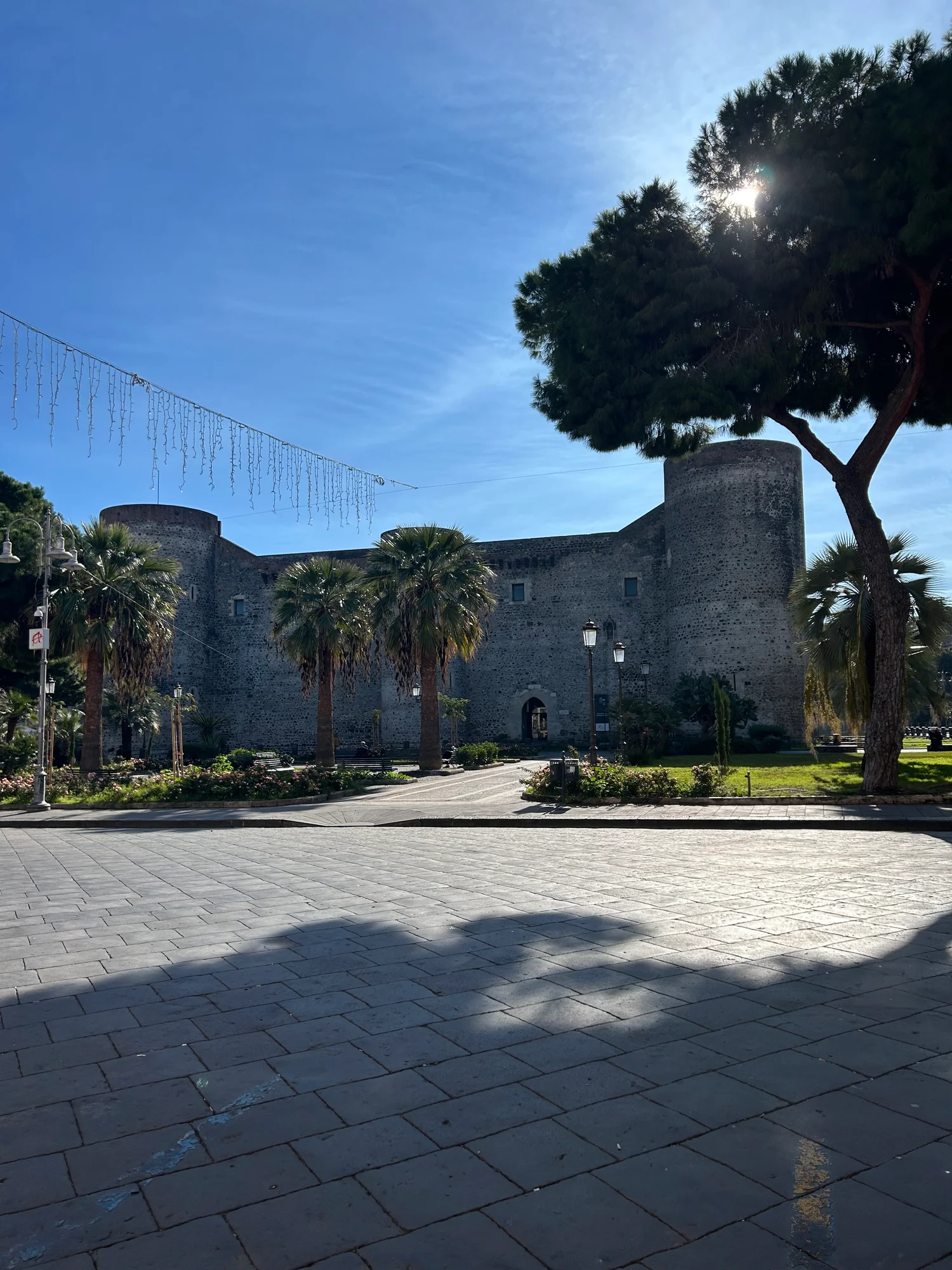
In the 2024 photograph of Castello Ursino, the ground in front of the castle looks like the surface of a city square. Stone paving and a conspicuous tree give visitors an ordinary distance from which to look at the towers. The sea is absent from the picture. By itself that absence could be a straightforward consequence of where the camera stood. Set beside the civic museum's account of the castle, it points to a larger change. The position of the castle and the position of the coast were once differently related.
Etna's eruption in 1669 sent lava towards Catania. The city's museum describes lava covering parts of the fortifications near the base of the castle and altering the shoreline. The two effects happened in the same episode but need separate lines on a drawing. One concerns material reaching a structure. The other concerns where a city meets the sea. A description that says only that lava came near the castle leaves out the change most easily overlooked from the modern square.
The building can be one of the control points
A map comparison begins with what one can still recognise. The castle offers a position and a footprint that can be used to relate maps of different dates, provided the editions and scales are known. The size and shape of the ground around it need to be supplied by the actual records. A short name or spectacular image of a historical eruption is not a survey of that ground. Place the castle and then inspect how the shore was described in each period instead of using the modern line as the starting point for every picture.
Imagine a profile with fortress walls and water on one side. Now make a later diagram in which new solid ground lies between them. The building need not move for the distance to water to change. The exact geometry of Catania is more interesting than the model and should be taken from appropriate records. The model shows a distinction: changes of coastline are capable of repositioning a landmark relative to water even if they do not make it necessary to change the point used to represent the landmark.
The museum connects the older location with the castle's strategic use. One can say something about the relation without retelling every military use of the building. The important geographic point is that a route at the shore and a route through streets put a building in different positions within a city. What it sees, what can approach it and what functions later make sense there may all change. Looking at the walls presently visible is a good start, followed by recovering the piece of geography that is no longer there.
A lava flow can cover and add at the same time
The INGV catalogue records the historical eruption, including the course of the flow toward Catania and the sea. Covering ground already present and adding material beyond an older shoreline are different outcomes of material moving downslope. Near an existing building the relevant change might be which part of its lower structure becomes visible. Along the coast the same event can alter the outline a future map uses to show dry land. One new layer can thus alter vertical and horizontal relations for quite different observers.
This is easy to miss in a general phrase such as the lava destroyed the view. A view did change. So did the ground that would have formed the foreground. Any detailed reconstruction should distinguish the front of a mapped flow, the depth of coverage at a certain point and the coastline following the event. They are not interchangeable measures. A dark area drawn in an historical image is useful for locating the story and for seeing what an artist chose to mark. It should not be made to carry exact modern survey dimensions.
The archaeological and building record supplies some of the missing vertical information. The civic museum describes uncovering old fortification fabric in the ditch after removing some material associated with the flow. That is evidence that what is visible can change again when a site is investigated or conserved. A visitor looking into an exposed area sees a present choice about what can be examined. It should not be assumed that the same part was continuously exposed after the eruption.
Keep the quake on a separate line
The museum also records damage in the earthquake of 1693. It describes effects on particular parts of the castle. That gives a second reason not to attribute every visible alteration to lava. The building can preserve several events in overlapping surfaces, in addition to work that happened long afterwards. A chronology can begin with the medieval castle, then give the flow and the earthquake their own dates. It can continue with later uses and changes that give evidence about the site the visitor sees today.
Calling a wall volcanic because it is dark, or assigning a missing tower to a single event because the event is famous, is a poor way to read that chronology backward. The appropriate method is to connect an observed feature to a documented change or to leave the connection open. Even when things happened within a few decades of one another, they can affect the building and terrain in different ways. Separating the episodes makes each easier to see.
A photograph of the square does something smaller. It shows what quite ordinary urban ground surrounds the castle from one point of view. The value is that such an ordinary sight can be compared with a place once described in relation to a shore. A fuller set of images and mapping would be more useful than a photograph in deciding how far the actual coastline moved. The short story visible in the photograph is the lack of open water directly around the base.
A change can persist after its most obvious trace is hidden
The eruption record puts the larger setting back around the castle. It describes an eruption on Etna's southern flank, rather than an event that originated beside the building. A reader following the flow in an appropriate map should not conflate the position of an eruptive opening with the point at which the lava reached an urban area. Nor should they treat the date when the eruption began as a statement of when every part of the coast was changed. Both the place and the time can differ over the course described in the record.
The question of position can also have more than one useful answer within the city. A building close to a waterfront may be described by the view provided from it. Someone on land may describe it by the route arriving there. When a shoreline shifts, both descriptions can alter without a change in the building's location on a coordinate grid. A comparison that keeps the coordinate point fixed while showing different approaches makes a more useful educational figure than captions that simply call the castle coastal in one year and inland in another.
Layered drawings can preserve details that would otherwise have to be sacrificed. The civic museum identifies covered features near the castle and places where older fortification was exposed again during work at the site. A drawing of an excavated section can put those relations above and below one another. A plan comparing old and new coastlines has a different axis of interest. Combining the two with related labels lets a reader see why both stories are about the same event without treating a dotted coastline as a measure of what was buried at the base of a tower.
A reader can trace an old view against later records without making the old drawing more precise than it was meant to be. A painter might emphasise the extent of an event. An excavation report names a smaller feature that can be measured.
Catania went on being a city. Routes, buildings and activities could spread over or around parts of the altered ground. At some points a visitor may encounter contemporary pavement where an earlier map might have shown a different surface. That does not make the eruption irrelevant to the geography of the place. The relation between the location of the castle and the later ground can survive in the arrangement even where bare rock is not offered for inspection.
A useful way to present the change is with dated sketches, one carrying only the older castle and edge and another carrying the newer edge and a few routes that help a reader locate it. Keep at least one fixed feature in both. Add the ground investigated near the ditch only where it can be clearly sourced. This lets the event be visible without requiring the drawing to invent a coastline in detail. Any area not resolved by the evidence can be left to the original plan or an appropriate geological map.
From the square the castle makes a strong enough figure to dominate a photograph. It is easy to let the surrounding city disappear from the story once the eye has settled on the stone. The old relation to water gives a reason to bring the surroundings back. The building can be old while the course by which people arrive reflects a later geography. Leaving the tower in place and moving the shoreline is the simplest way to see what makes the same address such a different position.