The Bend the Colorado Cut Into Rock
At Horseshoe Bend the shape a river can make across low ground survives among steep sandstone walls. Reading the bend from above and from the side gives two views of the same history.
In this story 5 sections
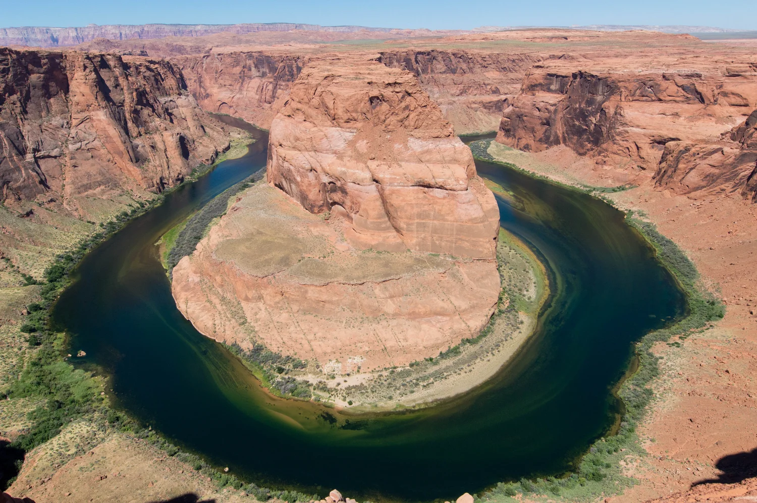
There is enough river in the photograph of Horseshoe Bend to follow the curve almost without moving your eyes off the water. It comes into view on one side of a broad piece of sandstone, swings around the front and doubles back along the other side. The top of the sandstone stands far above it. Trace the water on a sheet of paper and the result resembles a bend that might be found in open fields with very little difference in height from the river to the land behind it. The Colorado, near Page in northern Arizona, is plainly doing something on a different vertical scale.
The place lies in the Glen Canyon area. The National Park Service describes Horseshoe Bend as a remnant of a winding course preserved as the Colorado River cut down through sandstone. This is one reason to look beyond the resemblance to a horseshoe. There is a turn across the land and a great drop from high ground to water. To understand how the two belong together, it helps to keep one view that follows the river and another that crosses the canyon. The photograph combines them partly, but gives neither up without a second look.
A curve can form before a canyon grows deep
Take a gently sloping piece of country with a stream running across it. Its path can bend even when no high rock wall forces a turn. Through a bend, water and sediment often move in a way that gives the outside and inside bank different treatment. An outside bank can lose material while sediment gathers at a shallower inside edge. As that happens around several bends, the shape can change across the plain. There is no requirement for a turn in the river to be carved all at once by deep subtraction of solid rock.
A map of such a plain can be remarkably suggestive. Several points on a bend might be close as the crow flies and far apart by water. If two parts of a bend approach closely enough, a river in loose sediment may sometimes find a shorter route across the neck. That can leave a former reach apart from the main channel. This general picture explains what a bend can do in ground where lateral change is relatively easy. It doesn't describe an imminent change at Horseshoe Bend. Photographs of the Colorado show a much greater barrier between the adjacent reaches than a thin, low bank of soil.
The National Park Service places the carving of this route in the broader story of uplift of the Colorado Plateau and incision through its rocks. A river with a winding course can gain the conditions to cut down into its bed. If it does that over a long interval, part of the old pattern in plan can acquire steep sides. The banks that mark it then stand far above the active river. Its course has become entrenched, a word that says something about how difficult it is for the river to abandon the general route compared with a shallow stream across loose material.
See what an overhead line cannot measure
In the photograph a central promontory occupies much of the open space between the two sides of the river. Draw a line along the high ground across its neck. Then draw a second line following the water around it. The first can be considerably shorter without giving the river an available alternative. The high ground on the way across is part of the problem. A boat moving along the channel has to follow the water. A line drawn at the level of the rim describes another route with different obstacles.
A cross section across one arm of the bend reveals why the low course is hard to redraw. Two surfaces rise on either side, leading away from a relatively narrow floor occupied in part by the channel. Tilt the section relative to the river and it may meet the water twice, separated by a substantial piece of rock. Those two intersections belong to an upstream and a downstream reach. Seen on that slice alone they could be mistaken for separate rivers. Seen in plan they clearly connect around the sandstone. Reading the place in both directions brings those facts into agreement.
The directions also matter for the foreground of a photograph. A close ledge can appear to lean over a distant bank even if considerable space lies between them. A wide-angle view made to fit the whole turn can change the apparent scale of its edges. None of this makes the view inaccurate as an illustration. For measurements one would ask whether the desired distance runs along the slope, across the ground in plan, straight down or beside the channel. The answer for one direction should not be reported as if it answered all the others.
Watch the rock as well as the water
The photo shows changes of tone and detail through the heights of the canyon walls. Layered sandstone is an earlier part of the story than the modern view. The materials of the wall accumulated and became rock before the river exposed the surfaces a visitor sees. Incision then made it possible to inspect some of that older record from a high viewing position. These are events in different orders of succession: the rock layers read as one sequence, and the river cutting through them reads as a later process. A broad reddish wall and the river beside it do not have to be the same age to belong to the same landscape.
There is work going on above the level of the river as well. Water and loose pieces of rock can move down a slope without following the main channel from the head of the bend. Weathering along faces and around fractures can loosen material. Differences in coherence and exposure can leave ledges where some portions of a face persist longer than others. The river is crucial to developing a canyon, but the shape of every wall today is not a direct imprint of current at the same height. Side processes can affect how a cut through rock looks long after the river has reached a level below that part of the face.
A patch of colour or a small ledge in one photograph is not enough to identify an entire layer. A geological account or map puts such features in a larger context. From a distance, the existence of repeated bands, the orientation of the larger rock forms and the relationship of some ledges to the channel are already useful clues. Try to identify which observations can survive a change of light or a new camera position and which are probably about the way a particular scene was photographed.
Steep today and still a river
A confined channel still has an inside and an outside to a curve. The distribution of depth, current and sediment can vary around it. Observe where the photo appears to show a narrow shore or a change of colour near the inside of the bend. It is a reason to ask about the differences across the water, not a measurement of speed or depth. Sediment, glare and shadow can all affect apparent colour. What confinement tells us is that a great deal of the surrounding area is unavailable for the kind of easy lateral migration one imagines on a broad floodplain.
It is also useful to distinguish the long evolution of the shape from the conditions of one afternoon. Water levels can vary without erasing the bend. A little more visible shore on another date would say something about the grounds the water covers at those times. It would tell very little about how long the Colorado has occupied its course around the promontory. A question about recent flow might call for records of the river itself. A question about the preservation of a bend in an uplifted landscape calls for evidence on a much longer scale.
There is a reason the park name and the city name sometimes appear together in descriptions. The photograph helps locate the turn in a scene someone can recognize near Page. The river and the layers continue beyond the pictured point. Study of a single bend benefits from a wider view of Glen Canyon, where more of the relation of the river to the plateau is exposed. That wider view doesn't make this particular meander less legible. It makes it harder to mistake a beautiful outline for the whole physical explanation.
Make two drawings of the same curve
Begin with the fact suggested by the horseshoe name: the river returns close to its earlier position. Draw the turn on paper from above. Then add the height of the promontory that occupies the area between its sides. That second move explains why the short line across the figure is no substitute for the winding one in the water. The plane of the first drawing was good for recording the route. The second gives the banks and their height back to it.
The combination explains the unusual clarity of Horseshoe Bend as a view. From high ground the water's plan can be followed, and there is enough bare rock to see the relief that gives the plan its history. Follow the dark water once around the visible reach and then climb the central shape with your eyes. The moving river and that still piece of high ground have been part of one story for longer than any single view can show.