Read the Terraces Above the Douro River
The stripes in an Alto Douro hillside come from different ways of fitting work to steep ground. Look at what holds up one strip before following it down the valley.
In this story 6 sections
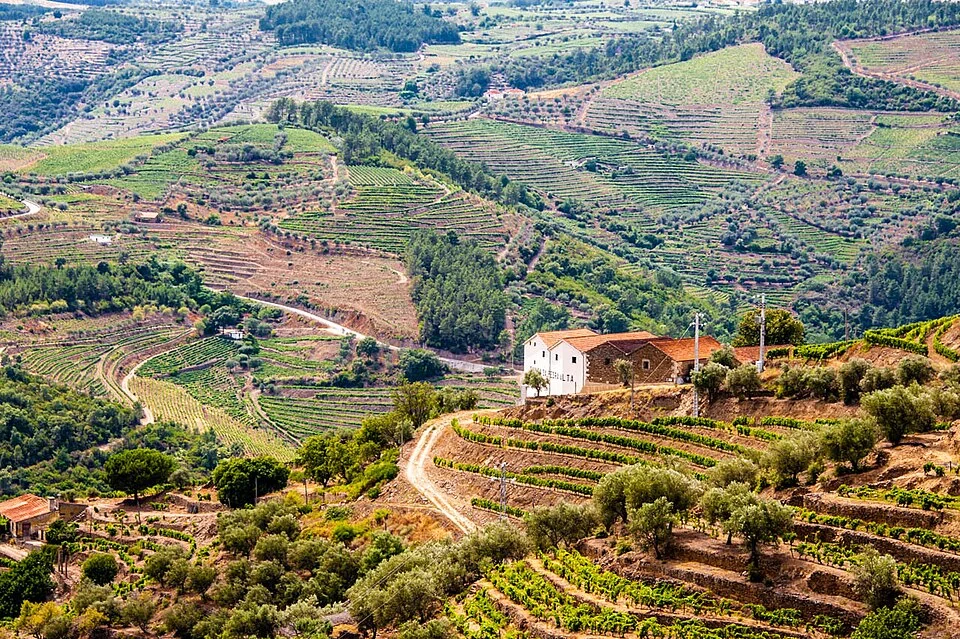
From across the Douro, the lines on a vineyard slope can look like technical marks on a drawing. Trace one with your eyes. It goes around a shoulder, follows a bend, and may narrow where it meets rock or a different kind of ground. What looks like a single line from far away resolves into an edge between a piece of cultivated land and the rise below it. That edge is a long piece of work, visible because somebody made a steep slope possible to use in a particular way.
Start with a cross section
Make a simple sloping line on a piece of paper and draw short steps inside it. The flat or nearly flat surface on a step gives soil and plants a different setting from the slope seen at a distance. The riser is where the change in height has to be held. The depth of the tread, how its inner edge drains and the material of the riser affect what can be planted or reached. A plan view is a good way to draw the rows. The cross section explains why they have a practical shape at all.
The UNESCO description of the Alto Douro distinguishes narrow earlier terraces supported by schist walls from later arrangements that used wider lines in some places. Differences in the size and continuity of terraces therefore offer clues about changes in practice. A wide photograph is rarely adequate evidence for assigning a construction date to a particular wall. The description is more useful as a reason to look for variation. Two sections of one hill can show different answers to the same problem.
Take the connecting paths seriously
Look for the marks that do not follow the slope along its length. A path or road has to bring a person, tool or load into the space between rows. Somewhere people must be able to change height. A short route in a photograph may be awkward on the ground. If your eye stays on the stripes, you can forget the places from which people came to work them and the routes along which materials and harvests travel. The terraces belong to a pattern that includes farm buildings, roads, watercourses and settlements as well as the visible planting.
Rain makes connections that paths do not. Follow a dip or gully and ask what could happen when water arrives faster than the ground can take it up. On a maintained slope, clearance and drainage can affect the condition of the walls below. A terrace landscape is not made once and then merely preserved in place. Its condition depends in part on repeated work that leaves few immediately recognisable marks from across the river.
Use the foreground to recover scale
The rows of vines establish a second scale once you can see where one row ends and the next begins. A line that looked finely spaced from across the valley may turn out to carry several planted rows. Another may use a much narrower floor. The UNESCO account describes some earlier terraces as narrow and irregular, with stone retaining walls and relatively little room for planting. Its discussion of later rebuilding describes different dimensions and shapes in some areas. Treat this as an invitation to find real variation in a slope rather than a simple key for attaching a date to every stripe.
The available light affects that reading. Low sunlight can pick out a riser by casting a shadow along it. On a bright day viewed from a different side, a face and the ground above it can seem nearly the same colour. Vegetation can conceal the ends of some older walls. An oblique view from farther along the valley can expose the point where one broad run breaks into several smaller ones. When using pictures as a guide to the ground, keep the direction of the light and the position of the camera with the observations.
To understand a view, find a person, tree, passage or row of vines that provides a rough scale. Then look at how many similar elements fit between two walls. In one place that count may be small enough to grasp at a glance. In another it can reveal how much larger a terrace is than the line originally suggested. Finally, return to the whole landscape. Keeping the height of the first wall in mind changes every stripe near it. The distance across the valley hides difficulty and creates a pattern. Looking carefully lets the pattern give some of the difficulty back.
Compare the path that climbs with the row that stays level
Draw a short vertical section from the river toward the top of a slope. Each planted surface occupies a small shelf along that rise, and the rise continues just beyond it. Now draw a line parallel to one row of planting. A person moving along that row has a different relation to the slope than somebody trying to reach the row above. Features that join the different heights can be relatively inconspicuous in a photograph even though they are indispensable to work on the land. Changing height repeatedly matters more when a person is carrying a load or needs to pass somebody else.
Pay attention to the places where the orderly stripes stop. One break may align with a track, another with a drainage line or an area left out of cultivation. A break in the planting does not always mean a failure to fill available ground. The visible interruption may be where the path meets several terraces, where equipment can turn or where a wall relates to an existing feature of the slope. It can also belong to another owner or a different period. Describe the break by what it does in the view before assigning a cause.
The same approach makes the villages and farm buildings easier to place. In a panoramic picture, a white group of walls can seem merely decorative against the rows. Put the approach roads back into the picture. A house has routes that connect it to work and to other people. Some routes to the river are direct from a distance and much less direct on the ground. The UNESCO account treats settlements, farm complexes, roads and the planting as related elements. You can see something of that relationship when a pattern of terraces has to make room for access to the rest of the valley.
Keep the labour of maintenance in the picture
Retaining structures and the ground behind them are exposed to the passage of water over many seasons. The condition that makes an orderly slope possible can be the result of regular attention. A close photograph can show an instance of missing material or a change in a surface. That does not establish how broadly the problem extends or which cause led to it. The useful observation is that a wall in the view is doing a job continuously, and its history can include repairs made at a different time from the construction of the terrace itself.
Compare the first broad photograph you saw with a later one taken from a similar position. Some changes in colour will depend on vegetation or weather. A lasting difference in the edge of a row may merit a closer look. If you cannot align the photographs using a couple of persistent features, hold off on diagnosing change from a single altered stripe. Another view or an on-site explanation might identify the place. A cultivated landscape contains change at several speeds, including changes in a single day’s appearance and changes in the arrangement of the land.
For a visitor, the closer view does not require walking into a working parcel. Look for publicly accessible viewpoints and follow the rules that apply there. A pair of views available from the road can help recover the direction of an edge and the relation to the river. Keep a simple sketch with the two views. The resulting note will say what kind of evidence it used and why. What seemed a pictorial pattern may now appear as a collection of different routes, supports and working surfaces held together by geography.
Find the edge in a photograph and an aerial view
Pick a stretch of hillside that can be identified in both an ordinary photograph and an aerial image. A road turning sharply or a group of buildings can provide a starting reference. Confirm which slope each image shows before following a row. From the river, foreshortening can make several changes of height look as though they sit in one plane. From above, the tracks that join rows may stand out and the heights of the walls can disappear. The two views are a good combination for separating work that was done along the hill from work that was done across it.
Notice what the agricultural lines do at the boundary with uncultivated ground. They may end without a visible path nearby, or curve into a different set of rows. Make the note about one particular boundary rather than trying to generalize from the entire scene. A wide summary such as “the slope is terraced” remains true and leaves out many of the decisions visible there. The smaller comparison is a way to keep their variety intact. It also gives you a reason to return to the ground view, where the surface of the particular wall may be more readily visible.