At Kinderdijk the Water Moves Between the Windmills
A row of mills is easy to recognize from the path. The channels on either side explain why some of the wind’s work went into moving water uphill.
In this story 4 sections
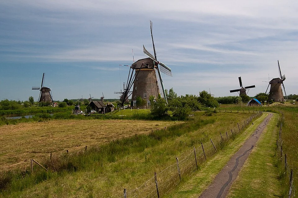
In a photograph of Kinderdijk the windmills look like the things being visited. On a map of the landscape, the strips of water could make a stronger claim. Water in one strip may be waiting to reach another part of the system. A stretch that looks level with the water beside it in a distant view may have the benefit of a small difference in height. The windmills are the places at which some of that difference can be overcome. Follow the water and a group of separate buildings starts to make sense as the working edge of a low landscape.
Kinderdijk is in the Netherlands, in a part of the country where dikes, channels, mills and pumping stations belong to a long history of managing water. UNESCO lists the mill network and related works at Kinderdijk and Elshout. The organization responsible for the heritage site describes how mills lifted water toward higher storage areas, from which it could be released when conditions permitted. The water being moved has somewhere to go, and the mill needs a source of energy with which to move it. Those two relationships can be easier to see one at a time.
Keep two water levels in view
Start with the area whose water you want to manage. Rain can collect on the ground and run toward ditches and channels. Water outside that area can at times be higher than the part from which somebody would like to drain. A barrier helps separate the two. It also makes a managed route out necessary. Water cannot simply run uphill from a low channel to a higher one. A mechanical lift can put it at a level from which a suitable later step is possible. That is enough to explain a major role for a mill before the details of its machinery enter the view.
A sketch can use two horizontal lines and a small gap between them. Draw the windmill beside a point where water can pass between those two parts of the system. From the path, the lines are much harder to compare because the bank intervenes, and widening or narrowing a channel changes how large its surface appears. The height difference that matters may seem small compared with the height of the mill. A difference of level belongs to a particular pair of water surfaces. The safest way to see it in a photograph is to look for the work connecting those surfaces rather than use the sky as a ruler.
Now look at the neighborhood around the channel. A ditch at the edge of a field is small enough to treat as a local feature. Several ditches joined into a route bring water from more of the landscape to a point where it can be lifted or released. Put the field and the route in the same drawing. A water level managed at one point has implications farther away because it affects how readily those other paths can discharge into it. A picture of a tidy ditch gives a very small part of an arrangement that works over a considerably longer distance.
A place for water to wait has a purpose
It can seem odd to pump water into a body of water that is still in sight of the place where it was picked up. The transfer does work if the second place puts water at a useful height or gives it temporary storage. A condition at the outside waterway can make immediate release impractical. The raised storage then separates two jobs in time: removing water from the lower area and finding the appropriate time to let it through the next boundary. When the receiving waterway is too high, a gate alone cannot create the necessary direction for gravity drainage.
Imagine an ordinary bowl with a small outlet placed inside a second vessel. If water outside the bowl stands above the opening and above the water inside, opening a connection can cause the wrong movement. Changing the height at which water is held or waiting for the external level to fall changes the question. The full landscape uses far larger structures and has recurring flows on both sides. The example preserves a point that is useful at the scale of a map: a route out is a conditional thing. A line cannot say whether the conditions are favorable at a given moment.
A visitor approaching from one bank sees a sequence of quiet stretches, green edges and bridges. A high body of water can look just as calm as the low channel. Its capacity for storage is not evident solely from the appearance of its surface. Look at where a bank surrounds the storage and where the next connection is located. The view can show how pieces sit together even when it cannot establish the level on the day the photograph was taken. A map supplied by the site can help locate the relationship without guessing what lies behind a distant rise.
The big rotating part is the input
In a traditional drainage mill the sails take energy from the wind. A transmission carries some of that work to equipment that moves water. When looking at a mill from the outside, most of what you can readily see is on the wind side of that transaction. Water can move separately from the visitor’s view. The site’s machinery and pumping stations offer other places to investigate the transfer. The puzzle for a viewer is to keep the conspicuous rotation and the more modest movement below it in the same account.
Wind varies. A system that depends on wind for some operations benefits from a way to cope with periods when it is too weak or otherwise unfavorable. Pumping stations introduced other ways to supply the work. A different source of power can change when the system can act, without erasing the need to handle storage and release in the same terrain. The history presented at Kinderdijk makes sense when read in these two layers. There is a changing set of machines and a persistent problem of water occupying the wrong place at the wrong height.
A row of mills can be viewed in relation to the water they served. One part of the landscape needs mechanisms at several locations because collection and movement do not all happen at a single point. Consider where the water has already travelled when it reaches one mill, and what has to happen before it can move again. That is a better starting point than assuming each building was made to perform the entire drainage operation on its own. The row has a reason even before a visitor knows the name of each mill.
Bring the banks and gates back into the photograph
On a public path, choose a view with enough foreground to identify a bank or channel clearly. Note which way you are looking. If another body of water is visible, see whether it belongs to the same uninterrupted surface or is separated by a barrier. A foreground edge now provides a way to talk about water that the distant silhouettes alone do not supply. If unsure about a connection, check a site map or explanation instead of treating the visible waterways as one level network.
When comparing a historic image with a current one, check what each makes visible. A long-lived bank may be recognizable even though the equipment doing the work has changed. A group of mills can be an excellent guide to historical practice without proving exactly which route water took on the day of a recent photograph. The reverse is also possible. One modern picture of an active pumping station shows where a current task is performed and can hide the connections that made such work useful in the first place. A description of change needs an identifiable place, a particular operation and evidence for the time it describes.
There is a useful next step on a local map anywhere with dikes or low fields. Pick one ordinary rain event and ask what would make it difficult for water from the lowest visible strip to leave. Follow a ditch to its next connection. Mark the edge beyond which the direction of flow could depend on a control or a different level. If your only evidence is an overhead view, keep the small arrows tentative. A map can suggest the next piece of information to look for before it tells you the complete route. This is a good way to see which parts of the problem belong to the land itself.
Return to the long view after identifying a likely transfer point. The photographic arrangement can still be admired. It now helps explain a line of work that goes through fields, reaches channels and waits for a suitable way out. The sails mark one place where energy entered that sequence. The low and high areas around them say why it was needed.
Keep a record of which side of a bank you could see and which side you inferred from the map. The distinction can help when a second viewpoint shows what appeared to be one expanse of water divided into two pieces. It also keeps a glimpse of the landscape during one visit from standing in for measurements that somebody responsible for drainage would take over many conditions.