How Water Reaches the Batad Rice Terraces
Seen from above, Batad looks like a hillside divided into separate fields. The water that reaches them comes from a system that begins beyond the visible edges of the terraces.
In this story 5 sections
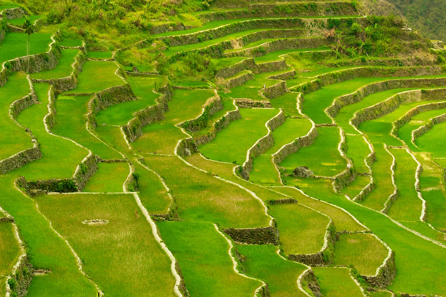
The lines across a photograph of Batad curve so often that it can be hard to decide whether to look at the wall or at the narrow field it supports. The two alternate from the houses low in the valley to the upper shoulders of the slope. Dark bands and patches of green produce their own broad pattern when seen at a distance. Whether the fields are planted, flooded or being prepared changes how readable those lines are. The photographer has caught a broad run of green. The surface that turns rain or irrigation into ponded water is mostly concealed under it.
Batad is in Ifugao, in the Philippine Cordilleras of northern Luzon, and its terraces are among the five clusters UNESCO includes in the World Heritage property. The organization describes an amphitheatre shape, with a settlement low in the hollow. The form invites a spectator to look from one side to the other and appreciate the whole slope at once. Water takes another route. It moves into and across the hill in smaller increments. Its route begins above the individual fields and depends on structures and land that can be easy to leave out of the photograph. The connections between these areas explain more about the view than the curve of any one wall.
The field needs to run level in one direction
A steep site offers plenty of assistance to water on its way downhill. A rice terrace must slow some of that movement long enough for the field to be farmed. Walk the length of the strip in an imaginary cross section: there is a hillside on the inward edge, a retaining wall built down the outward edge and a working surface held between them. The hill can fall sharply from one strip to the next while the surface within each strip is nearly level. In plan view the strip bends where the hill bends. In a section cut across its width it has something in common with an ordinary lowland field: it can hold water over much of its area at the same time.
Not every green patch necessarily holds the same depth. If a shallow layer can be managed, water and soil need to stay within the chosen boundaries. Small differences in elevation decide which low point the water reaches first. A damaged edge introduces a new low point. A pond that loses water more quickly than it receives it can expose the higher parts before the lower parts look much different. From a distance this can read as a change in colour; beside a field it would be a different set of conditions for farming.
The height of the wall is related to the width of the field and the steepness of the ground before it was shaped, but walls cannot be read as simple units of equal size from a distant view. A strip that looks uninterrupted may narrow behind a bend. An upper edge can hide a section of retaining wall. Some of the photographic rhythm comes from perspective, with lines close to the observer easier to separate. One reason to ask about water instead of counting lines is that the question still makes sense where the nearest folds overlap.
Water starts beyond the frame
UNESCO's documentation treats the water source, forest above the terraces and the irrigated fields as parts of one landscape. The upper catchment is where rain can collect and feed flows that later become useful to farmers. Vegetation and soils influence how quickly rainfall arrives downslope and how much sediment it can carry. The fact that a green slope lies above a field does not tell a viewer exactly which channel serves it. It does explain why work and decisions above the photographed bands matter to the paddies below.
The difference between a shower and irrigation is particularly useful. Direct rain lands broadly, whether the same amount is needed everywhere or not. A channel directs some water along a chosen line. It can bring a supply to a field whose own area is much smaller than the land where the water gathered. It can also spare a field that would take too much water if all of the nearby runoff came down through the same opening. Keeping a usable path from catchment to field involves more than having enough water in a valley considered as a whole.
Think of two points on the slope that look equally far from a stream. The higher one may sit above the level at which a channel is able to deliver water by gravity. The lower one may sit past a bend where a narrow passage needs maintaining. The points that are close on a flat map need not be equally easy to serve. The same applies to a photograph: a dark line behind a wall could be a shadow, an edge or a route along which water can actually be moved. It takes local knowledge of the ground to decide which.
Following one share of the supply
Imagine a small flow entering a terrace. It needs a path across the field or along its side, depending on how the supply on that part of the hill is laid out. Some water stays where it is needed; some can pass on. In a stepped landscape the next lower terrace is an obvious possible recipient. The picture makes this connection seem inevitable. Actual flow is more complicated. Branches in a channel may send water one way while another area is being prepared. A useful inlet can be almost invisible on a wall whose main job is to retain the earth behind it.
Time supplies a dimension that a photograph omits. A field in one phase of cultivation can need different treatment from a nearby plot that is being readied for something else. If several areas depend on the same limited flow, deciding when to divert it matters alongside the capacity of the channels. An upper blockage or breach can affect more than its immediate neighbours. There may still be water in the valley; it just no longer arrives where it was expected. A branch that carries enough in a wet interval can require careful attention in a drier one.
This leaves room for two kinds of knowledge. One is knowing the shapes of the inlets, channels and retaining walls and how to work on them. The other is knowing who depends on a flow, when a change will matter and where the effects will appear beyond the part someone can see. There is no reason to expect the five listed clusters to share identical arrangements at the scale of particular fields. The general relationship holds: a landscape made of small plots imposes a larger problem of coordination.
A repaired wall belongs to the landscape
A completed wall is an easy subject for an image. A section with stones being re-set, or soil being consolidated to recover a lost edge, is an equally important part of a place still worked. Recently disturbed ground may look like an interruption in a neat line from across the valley. If repairing it restores a field's level, a channel's passage or the support needed by an adjoining strip, the interruption is part of what keeps the whole view legible. The heritage property is a lived and farmed place. It cannot be kept by preserving the outline of every wall while neglecting the uses that require it to function.
What makes that difficult is the combination of scale and repetition. An individual section can be small. There are many sections, and a difficulty in one may become a reason to inspect the next. The lengths visible in the photograph are evidence of work accrued, not of work already finished for good. Differences in access can make the same physical task easier at one location than at another. A wall near a workable path can be reached differently from one on a pinched strip that can only be approached from neighbouring fields.
There is also a distinction between protecting a recognized site and valuing every contributor to its water. A woodland or channel may receive less attention from a first-time viewer than the central sweep of terraces. The fields' dependence on those less conspicuous parts is precisely why the boundaries of appreciation have to extend beyond the points that make a good photograph.
What the picture can show
Begin with one line in the middle of the Batad photograph instead of the whole bowl. Trace it until it is hidden or until the distance makes further tracing impossible. Its origin and the end of the part you can follow may be at quite different heights even though small surfaces beside it are arranged to hold water. Then pick out another line uphill. Ask what must be true for the upper strip to receive a steady supply and for the lower one to get the water it needs without losing the earth it stands on. Changes in height, a working inlet and a channel fed from outside the visible strip would all help to answer the question. The picture gives none of their measurements, but these are the reasons to look for them.
Finally, turn attention back toward the upper green land, or beyond the photograph if that is where the source would have to lie. That move connects the most frequently pictured part of Batad to the other ground the terraces need. The finest detail of the picture is an alternating pattern of walls and planted strips. The finest detail of the working landscape may be something the lens cannot resolve at all: water arriving in the right place slowly enough to stay.