Why Seawater Takes the Long Way Through Guérande’s Salt Pans
The low banks at Guérande make sea water take a series of deliberate steps. The path gives the tide, weather and salt worker different roles in the same harvest.
In this story 5 sections
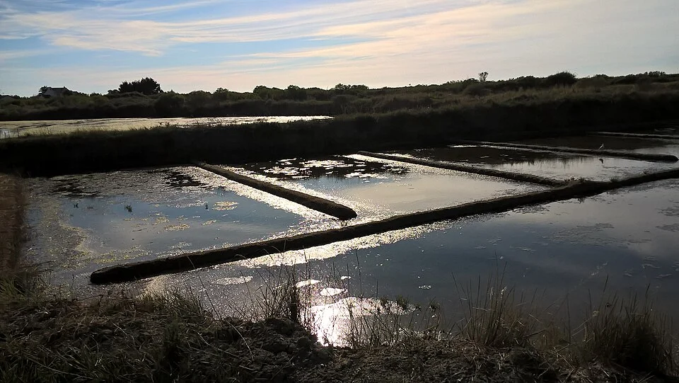
From a road at the edge of the salt marshes near Guérande, the visible thing is a pattern of low banks. They turn around shallow stretches of water and separate one surface from the next. On a still day two adjacent pans can reflect the same sky. They may be doing different work because the water in one has spent far longer in the system than the water in the other. A shallow surface that looks much like its neighbor can represent a much later stage in the making of salt.
The Guérande peninsula is on the Atlantic coast of France. The salt workers’ cooperative describes a route that begins with sea water admitted from tidal channels, continues through storage and evaporation basins, and ends in the shallow places where salt is gathered. A vista of the marsh makes the system look broad and almost level. A useful description starts by giving those surfaces an order. Much of the work of the land lies in making it possible for water to move gradually from one place to another when the other conditions are right.
Give the first basin a different job from the last
Think of the first large basin as a reserve admitted from the sea under suitable tidal conditions. It provides a place for the water to wait and for some suspended material to settle. The cooperative describes this first basin as a vasière. It belongs nearer the beginning of the sequence than the shallow crystallizing pans. A visitor who treats all the visible rectangles as places to gather salt misses the large proportion of the marsh used to make a gatherable result possible somewhere else.
Water continues through a series of other basins, often under a slight change of level, before reaching the smaller basins called œillets. The details of the connections matter. A gap seen over a low bank can be a route for water to pass, a place where a worker can control levels, or an opening doing another job entirely. A map of one working unit or an explanation from a practitioner can help identify which is which. From across several banks, it is usually easier to identify the existence of the series than to identify the exact order of unfamiliar channels.
One reason for distributing the route across many surfaces is that evaporation needs time and exposure. A deep reserve and a very shallow pan give water different contact with the conditions above it. Holding the same volume in a wider, shallower space can expose more surface. The actual behavior still depends on the weather, the inflow and the way the levels are managed. The photograph’s low banks make it possible to consider how a large surface is divided. The reason for the divisions becomes clearer once you know they keep water available at more than one stage.
Time enters from the sea and from the sky
The tide has a schedule that does not follow the workday. A suitable high tide can make it possible to admit water to a reserve. Further along, evaporation proceeds according to the conditions over the exposed basins. Wind, sun and moisture in the air affect what can happen in a day. Rain can add water at precisely the stage where somebody intended to reduce it. These influences do not necessarily cooperate. The first part of the site has to take advantage of an opportunity to receive water, while the later parts have to keep useful progress toward a concentration at which salt can form.
As a thought experiment, picture two identical shallow dishes that both begin with a known quantity of salty water. Leave one exposed while allowing rain to enter the other. The salt already dissolved does not disappear simply because more water arrives. The mixture in the second dish becomes less concentrated if the added rain is sufficiently fresh and remains with the liquid. The two dishes may look similar again after a while. Their visible area is poor evidence for their exact contents. This helps explain why a worker cares about the amount and timing of movement between ponds rather than merely about seeing a full surface.
The same comparison shows why “collecting sea salt” can lead a visitor to look at the wrong place. The name suggests an action taken directly at the sea. The notable part of this landscape is the time and separation between receipt of sea water and gathering the crystals. Water is a carrier through much of the sequence. What is left at a useful stage depends on how the site gives it places to stay, places to move and exposure to its surroundings. The longest part of the work is hard to compress into an image of a rake making one pass.
Notice the work that keeps a low edge continuous
A bank just high enough to divide two shallow spaces can have significance out of proportion to its height. A small change at an edge can matter if it changes where water leaves a basin or joins another one. Walking along a permitted public route gives a close view of the relation between the surface and the bank. An aerial photograph may make the full arrangement clearer and obscure how much difference a local edge creates. Use both viewpoints to think about the size of the decisions rather than to diagnose a particular site from a distance.
A salt worker also needs to reach the places where an adjustment or harvest is possible. Some narrow paths are working routes; they may not be open for visitors. Observe from public places and pay attention to the connection between a usable path and a point at which something can be reached. A wide panorama can make access look universal. A closer view can show that the layout contains distinct areas and that a person has to approach them in a particular order. The land is arranged for both water and work.
Part of the labour can be nearly invisible in a successful scene. An intact edge might simply appear to be part of the ground. A clear connection can sit quiet between movements. A useful historical description gives these pieces their roles without pretending that every line in a modern photograph dates to the beginning of the marsh. People continue to manage water and keep structures usable. The recognizable pattern is evidence of repeated work, with the weather taking a considerable part in determining how that work proceeds at any moment.
Read two adjoining surfaces with different questions
Find a picture wide enough to show several basins and small enough in view to distinguish a few connections. Identify a larger receiving or storage surface, if it is marked in the source. Then look for an area where the divisions multiply and become small enough to reach from narrow banks. Put those two observations in order. They show a change in how the water is held, which can guide you toward a different kind of activity. If the labeling is insufficient, keep the observation about size and connection without guessing at a precise stage.
The water line, the earth and the movement of people give the marsh three distinguishable rhythms. One involves the sea and the occasions on which water can be taken in. One involves time spent exposed in a particular place. One involves people maintaining the boundaries and acting when a useful state is reached. The view at Guérande accommodates all three. Follow one edge until you can see where water might continue, then keep looking long enough to find a reason for the time it spends there.
The same pond can look different over a season
A seasonal comparison helps separate visible work from the continuity of the land. The same arrangement of banks may appear in two photographs even when water levels, colours and activity differ. One picture can catch a harvest or an active adjustment. The other can show a place being prepared or waiting through conditions that offer a different kind of work. The pattern alone cannot establish which operation is taking place. Record the time of year and any reliable explanation supplied by the person running the site.
The cover photograph offers a way to practice that description. A repeat visitor might use a bend in a bank or a line of several openings to identify the view again. Put the most stable features in the note first. Then describe the qualities that can change, such as which areas have an unbroken reflection and how high the water appears against a marked edge. If the view was far away or there had recently been rain, include that detail. It explains limits in a record without making it impossible to compare any two observations.
For a visitor used to reading the shore from cliffs or beaches, the salt marsh supplies a low, divided coast in which individual lines of movement involve both weather and decisions. Water can reach the land without advancing automatically through all the places prepared for it. A worker’s knowledge comes into view when you ask when the water would be admitted to the next part and what stage of the work that change would serve. A map of destinations becomes a description of a process with waits, interruptions and useful moments.