An Istanbul Ferry Ride Starts Before the Pier
A useful map of a ferry crossing includes the streets approaching both terminals and the waits that never appear in a line drawn across water.
In this story 7 sections
On a map, a ferry across the Bosphorus looks marvellously direct. The line leaves one shore, traverses open water and arrives on the other. Put a real origin and destination on either side and the usefulness of the line depends on two more pieces of geography: how to reach the correct boarding point and what happens after the boat arrives. A pier that is a little farther away on the screen can be the better starting point if its approach is direct or its service fits the time of day.
Draw the walk as carefully as the crossing
Begin on a street several minutes from the water. Which entrance takes you toward the pier? Is the street divided by a wide road, a slope or another facility that cuts off the direct path? Draw the actual approach instead of a diagonal between two map pins. Mark the moment when the name or destination of the route becomes visible. On a return trip you might be approaching a different group of boarding points than the one you began from. A ferry terminal is a place to make choices as well as to reach the water.
Şehir Hatları publishes schedules and a history of the operator. The schedules separate routes and directions. If you are comparing two crossings, confirm both pier names rather than searching only for the district you want to reach. Routes can call at several places; the order of stops is part of the time. For an actual trip, check the operator’s latest timetable and service notices. An old itinerary or a photograph of boats at an attractive berth cannot say when service departs.
The waiting time belongs to the route
Take two imaginary options. One is a twenty-minute crossing and one is a fifteen-minute crossing. If the first departs just after you arrive and the second requires twenty minutes at the terminal, the quicker boat can produce the longer trip. Now imagine making the return in the evening. The better approach in daylight and the timetable that fits a morning commute may not tell you much about it. Travel time is a joint result of the street, timetable and person arriving.
It is also possible for a ferry to be preferable without being the fastest. A traveller with a bag may care about the changes of level. Somebody meeting a friend might put a high value on knowing which pier exit to use. For a regular passenger, a familiar place to wait can matter more than a particularly attractive view. Different travellers make the connection from the same physical pieces.
Use the view in both directions
The water changes what distances feel like. A building visible on another shore can provide a reference for the angle of the crossing and still be far from the landing. Draw a short line from the ferry’s approach to the part of the shoreline you can see clearly, then a second line from the actual landing toward the intended street. Those two lines can point in quite different directions. A traveller who starts with a recognizable building as an anchor needs a way to identify the last street connection as well.
An evening crossing can also change what is recognizable. The approach to a well-lit pier may stand out while the entrance to a small street is less obvious. Someone making the return journey after dark can benefit from identifying a broad road or transport connection before looking for finer street details. None of those observations tells them whether the boat is running. The operator’s updated information still matters, especially around changes in service or exceptional conditions. Keep the stable features of the place in one record and check the operating situation for the day of travel separately.
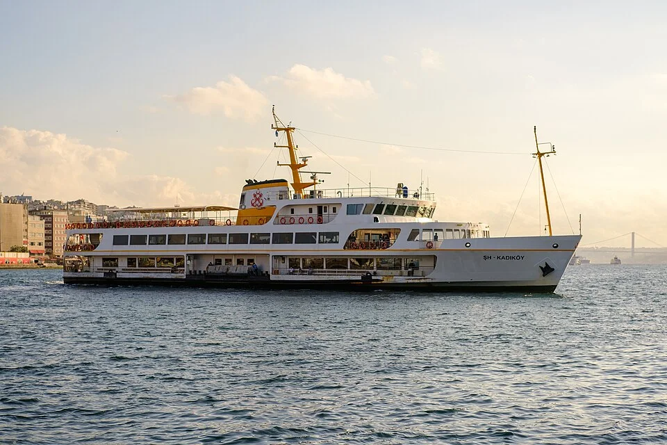
The cover shows a vessel and the water through which it passes. The route begins on land. To place it as part of a city, turn around at the pier, look at the buildings and streets behind it, and ask what the next step would be for somebody arriving. Repeat the exercise on the other shore. If you do it before looking out toward the water, you see why the ferries can serve at once as sightseeing platforms and as mundane parts of someone’s day. Their great advantage is that two coastlines can be read as a route rather than as separate margins.
Make the transfer explicit
At a busy waterfront, a pier can be close to several other routes without making every transfer simple. A bus stop across a broad road may be a longer walk than the pin on a map suggests. A rail connection can require a particular entrance or a change of level. Imagine giving directions to somebody who cannot see the ferry or the station from where they first set foot ashore. What would they need to recognize first? The answer might be a signed exit, a pedestrian crossing or a landmark visible from the pier approach.
A short transfer with many choices has an uncertain duration for a stranger. A longer walk along a clearly marked route may be easier to forecast. Use two time estimates when comparing choices: the time when everything lines up smoothly and the time that allows for checking a sign, waiting at a crossing or missing one connection. This approach captures the difference between a physically short distance and a connection that feels dependable. A daily passenger may already have absorbed the work needed to make the quicker option function.
The stop name can be another source of error. District names name large places. Piers are specific pieces of shore. Check which name identifies the berth where a particular route is expected to call. Ask whether an operator’s schedule shows a direct crossing or lists intermediate stops. Then look at the end of the route with the walk as part of the plan. If the last street is especially hard to reach from one pier, a more useful final landing could outweigh a small difference in time spent afloat.
A working waterfront can hold more than one timetable
A passenger sees ferries, routes and waiting groups moving in a space that may serve other kinds of traffic. The waterfront must accommodate the movement of boats into and out of the berths, the people getting off and the groups preparing to board. Each operation has a schedule. Their visible overlap is good evidence that the route has several layers of organization. A departure time describes what a particular trip is meant to do, while the movements around it can tell you why boarding begins at one place and why a crowd briefly forms at another.
When a ferry arrives, watch from a permitted position on shore as the disembarking group disperses. Some passengers will go directly along the waterfront and others will enter streets leading inland. The usual flow gives a rough sense of where the pier sits in the surrounding network. It may not tell you what these particular passengers intend, or which public route suits your trip. Follow the signs and record the path you could identify. The view becomes useful when it makes a likely next action visible.
Make a comparison somebody else can use
Give the person comparing two routes an imaginary starting point and the same final destination, then write down the available divisions of time. For example, one option might take seven minutes to reach, eight minutes of expected waiting, twenty minutes afloat and five minutes of walking beyond the pier. A second might take twelve, four, sixteen and ten minutes respectively. Both amount to roughly forty minutes. What separates them is where that time is spent and how sensitive the result is to the next departure. The numbers are illustrative. Their useful part is the comparison of corresponding pieces.
Record the actual entrances and any signs you needed to find. Another traveller can replace the example’s times with their own and preserve the relationship between the crossings. That is better than a fixed verdict about which ferry is quickest. The trip’s geography is a durable part of the description. Its pace changes as timetables, approaches and passengers change.
Leave some room for the next departure
People often plan a connection using the time listed beside the boat and the time listed beside another vehicle. A schedule comparison has to allow for the walk between the two and the boarding arrangements at each end. If a traveller needs time to find the correct entrance, the fastest connection on paper can be especially fragile. Look at the time of the following departure as well. A missed service that will run again soon has one kind of consequence. A long gap on the return trip has another, even when the water crossing itself takes the same time.
The comparison gets clearer if you draw the pier as a short process rather than a dot. Enter, check the route, find the boarding position and wait. On arrival, reverse that process far enough to reach a point where another route can actually begin. Each step can remain easy while their total still matters. If the time is tight, look up the operator’s current information about any service change and use the terms it uses for that route. Once the landing and street are both in view, the line across the water makes a far more reliable plan.