A Valley of Fairy Chimneys
Cappadocia’s pinnacles are part of a wider terrain of ridges, cuts and rock-hewn spaces. The shape of one chimney is easier to read when the surrounding valley stays in the picture.
In this story 5 sections
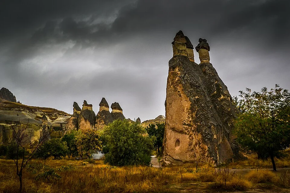
The rock in the foreground of Iain MacFadzean's photograph has two prominent tops. Behind it are smaller forms with points and caps that stand out against the sky. The names that visitors give these rocks often make them sound like isolated figures placed upright for effect. Leave a little more of the ground in the picture. The isolated forms begin to look like parts of a terrain: rising from a slope, standing near one another and separated by cuts that drop out of view.
UNESCO describes the Göreme area of Cappadocia as a volcanic landscape shaped by erosion, with valleys, ridges and pinnacles often called fairy chimneys. Türkiye's Ministry of Culture and Tourism describes several locations and some ways their shapes differ. The cover photograph illustrates the varied landscape rather than identifying exact units of rock for each visible form. To make sense of a chimney, begin with that wider setting before trying to attach a history to every isolated top.
The hollow and the pillar are connected evidence
A rock pinnacle has material in it that is no longer present immediately beside it, or at least is not present in the same shape. Erosion is useful as an explanation because it describes how material can be removed unevenly. It is not a claim that a valley was excavated in one step or that every vertical structure has exactly the same origin. Geology, slope, fractures and the routes water can take can affect which portions remain visible and which erode more readily.
A map can present the result in terms of positive forms and negative spaces. Draw what stands up, then draw where the ground descends between those shapes. The spacing sometimes has more to say about the terrain than the silhouette of one chimney. At the scale of the photograph, a dark space behind the main rock may look like a simple interruption. A higher view or contours could show how that interruption continues into a more substantial cut.
The comparison works in reverse as well. A photograph from the valley floor can make the nearest pinnacles appear separate from any ridge behind them. A distant photograph could make their outlines overlap. Neither image has made the rocks grow together. Before using apparent separation to decide how many distinct forms are visible, look for changes of viewpoint or a useful map. Being able to name which face looked isolated is a better result than deriving a whole landform from one outline.
A cap can help explain differences in shape
Some famous pinnacles in Cappadocia have a prominent mass over a narrower body. A simple explanation given for many capped formations is that materials of differing resistance can come to stand in different relations as erosion proceeds. A relatively resistant part can persist above a part that wears back differently around it. The actual effect depends on the rock and structure at the site. It is a reason to look at the layers and visible transitions, not a formula assigning a named cap to every silhouette.
The ministry describes places such as Zelve, where three separate valleys hold formations that include sharp tops and thick trunks. A family of shapes can be recognised without making them all stages of one standard diagram. One chimney may display a clear overhanging top; another may taper. Look for what can be learned from the distribution of forms across a section of valley. The presence of a neighbour with a different profile is part of the evidence, not an exception to crop out.
A photo with one form close to the camera invites a more specific question: where does its structure begin to look different as the eye moves upward? A line can be fairly abrupt or traced only by colour and shadow. Describing what can actually be seen is different from identifying its composition. A field description, rock sample or published geology can provide that next kind of evidence. The ordinary photograph is useful precisely because it makes the distinction visible enough to ask about.
Some openings belong to the rock and some to the people who used it
A landscape of rock faces can also contain buildings and rooms. UNESCO describes rock-hewn sanctuaries, dwellings and settlements as cultural features within the wider area. Choosing a good approach to that evidence means not assuming that every opening is either purely geological or obviously carved. A recess, doorway or altered face should be interpreted using its position and relevant documentation. The understandable desire to find a story in every dark square can lead much farther than the image supports.
The official heritage material on Zelve and Paşabağları illustrates how particular sites connect geological forms and places people have used. That does not make all the lower ground shown in a photograph one settlement, nor all the pinnacles parts of one date. It does show why a map of Cappadocia is often about different structures sharing a landscape. A trail or building plan can help identify which forms people approached and where changes were made. A geological map concerns a different layer of the same setting.
A chamber inside rock and a free-standing tower also need different representations. One visible outline can give little idea of a room cut behind a surface. A plan through a chamber can give little idea of the slopes reaching it. If the two are put together, let them keep separate legends and measurements. This makes it possible to talk about a human space without dissolving the whole valley into a collection of buildings.
Keep the valley after looking at a favourite silhouette
The word volcanic names a broad part of the landscape's origin. It does not mean the individual chimneys were built upward in their present shapes by separate eruptions. The UNESCO description joins volcanic material to later erosion. Keep those stages apart in a simple sketch. One shows layers and rock being placed or formed; another shows the surfaces and drainage that can later remove and expose parts of them. The chimney is a result that can tell us something about the different parts of the terrain, although it cannot tell the entire history of the volcanic field by itself.
As the landscape changes, material leaving one location has to go somewhere else. A sloping face can supply fragments to the lower ground. Fine material can move farther depending on the conditions. Nothing in a still image can establish the path of one grain, but the distribution of ridges, cuts and flatter areas lets a reader identify where to look for evidence of movement. Keeping the low ground in photographs is thus not merely a way to make a handsome view. It helps preserve the context for asking what happened around the remaining rock.
Time enters that account in several ways. A historical photograph can place a form at a date and show its relation to easily recognised surroundings. A second photograph from a different vantage point may be too unlike the first to establish physical change. A survey that measures the same face consistently can answer a different question. UNESCO's account also notes that some structures and formations have been affected by natural processes such as earthquakes. An observed change should not automatically be explained as the same ordinary weathering that helps explain the wider landscape. The scale and time of observation matter.
The place in the list and the place in the picture
The World Heritage entry names a group of landscapes and sites in a particular area of Cappadocia. A single image labelled with the broad regional name need not depict every type of site or tell a reader whether it sits within a mapped boundary. Where exact location matters, start with the named site and relevant map. If the evidence supports only a regional caption, leave the claim at that scale. The people who recorded an archaeological chamber can have a precise answer about its location without needing to identify every pinnacle that happens to appear nearby.
That distinction helps people compare places without ranking them by how closely their silhouettes match. One valley may be useful for seeing distribution of forms. Another may have spaces cut in rock that show particular kinds of occupation. It is possible to include both while asking one careful question at a time. A visitor guide prepared to locate a sanctuary and a geological account prepared to show layers are entitled to make different selections.
The photograph's dark sky gives the forms strong outlines and the vegetation gives the lower ground a different scale. Compare the two nearest prominent pinnacles with more distant ones and then look at what lies between. That is a simple way to recover a landscape that could otherwise be reduced to a picture of one unusual cap. Do not expect the same foreground to answer where all the routes, rock units and openings in the wider heritage property lie.
A fairy chimney is a useful name because it helps a viewer recognise a shape. The valley is useful because it shows that shape in relation to erosion, other formations and historic use of the ground. The best explanation keeps moving between them. Step out to see where the rock is situated. Step back in to see which edges and surfaces make it different from its neighbours. The silhouette becomes more interesting once it no longer has to tell the story alone.