A Dune Between Two Waters
The Curonian Spit divides a lagoon from the Baltic Sea. The woodlands, villages and bare dunes along it belong to a long effort to live with moving sand.
In this story 4 sections
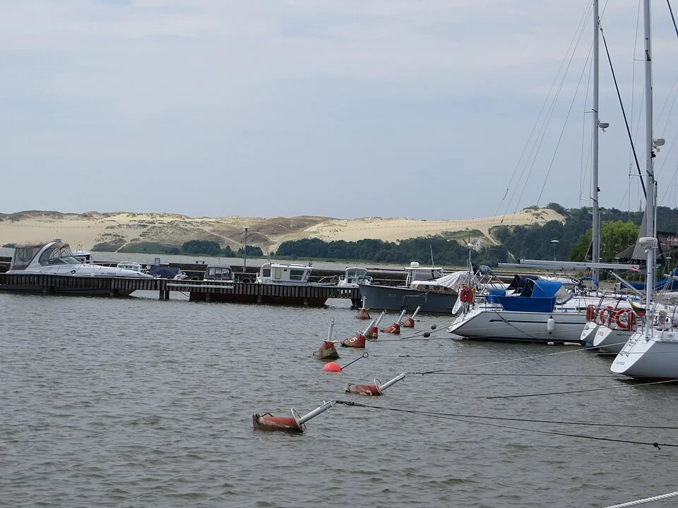
Look at the Parnidis dune from the harbor at Nida and the first interval you notice may be the broad water in front of it. It is quite easy to imagine the dune facing a sea where it rises at the back of the view. The harbor is on the Curonian Lagoon. Beyond the land behind the dune lies the Baltic Sea. In a photograph from one shore the two bodies of water cannot do much to announce their different positions. On a map their difference explains why the land between them is such a slender and consequential shape.
The Curonian Spit runs along the Baltic coast on a narrow peninsula shared by Lithuania and Russia. Seen from far enough above, it is a line dividing open sea and lagoon, stretching for about 98 kilometers in the UNESCO description. Seen in section, it has alternating slopes, width, vegetation and dune forms with quite different histories. Keeping both images in mind makes it easier to talk about the motion of sand without expecting the whole peninsula to have behaved as one enormous dune.
Separate the way the spit formed from the way a dune moves
Coastal currents and transported sediment helped form the Curonian Spit over a long period. The water and the sand had many places to go before a narrow piece of land became the characteristic form on a map. That is quite a different process from wind picking up sand from an exposed surface today and carrying it across the ground. The two can be related through a supply of sediment, but in a clear description use separate arrows for the journey of particles along the shore and the way sand may move across the exposed land.
It is possible, in particular, to be quite sure that a patch of open sand would be moved by wind without being able to say whether the shoreline as a whole is growing in that place. The shoreline depends on a wider balance of sediment movement and water conditions. A path that needs to be cleared after the wind and a beach outside a woodland may not be giving the same kind of evidence. What changes at one point is a useful prompt to ask about a larger process. It is a poor replacement for measuring that process where it actually acts.
Now make a second drawing of a line from sea to lagoon at approximately the place of the photograph. Mark the rising ground toward the dune and the place from which a person can see it on the lagoon side. Some sand surfaces will be hidden behind the visible slope. Woodland can occupy ground out of the view. An apparent boundary between exposed sand and trees tells you something about one side of the dune. It does not tell you that its other side has the same exposure or arrangement. The cross-section puts a very large sea and an almost unassuming local turn of the ground in one useful view.
The forest is part of the history
UNESCO names the spit as a cultural landscape and describes a history of human attempts to stabilize dunes, including tree planting and other work. The technical evaluation discusses protective banks and stabilization measures used to address sand movement. It is a surprising account if you come to the wooded part of the view with a simple belief that trees represent the original state and sand the absence of intervention. In some parts there was substantial effort to get exposed surfaces to behave differently and give inhabited land a measure of shelter.
Imagine an edge of sand with a low wind barrier across it. Air moving through and over the barrier can lose some of its ability to move particles at a particular spot. Sand can collect there. Plants that establish themselves can change the behavior of the surface again. A small local structure is then part of a much larger attempt to organize where sand is free to travel and where it is held. On an ordinary map the barrier and a tall dune can merge into one uninformative symbol. History shows why each might have to be represented separately.
Stabilizing some places does not make the work identical everywhere. Planting in one place and leaving an active surface open elsewhere can preserve different things. A plan for protecting a settlement has a different purpose from a plan for retaining an open dune landscape. Think about the downstream side of a decision that removes or traps sand. Where was that material going before? It may not be valuable in the yard of the next building, and it could matter in a place where a dune formerly received a replenishing supply. A complete management account should let people put those two effects on the same map.
Give the village room on the drawing
Nida lies on the lagoon side. The photo from its harbor gives it a human scale that a diagram of the entire spit can lose. A boat and a shore offer visual clues to distance and occupation. The slope farther away can dominate the field even if it gives no immediate indication of what crosses in front of it. Someone coming from the sea side would have other landmarks. A route placed on the map connects the two points of view without making one of them the background to the other.
People living with moving sand cannot choose their position strictly according to which view is most pleasing. Places become attractive or vulnerable according to their water access, ground and exposure. A forest belt can become important to habit as well as to the movement of sediment: its location changes which sections of road look sheltered and which part of a dune appears open from town. Those relationships by themselves do not identify the exact time or reason a village changed its position. For that use, compare the accounts of past settlement and original routes to the photographs that let you see what the land now contains.
A photographic comparison can do another job surprisingly well. Notice where the dune projects against water, where trees meet the slope and whether the photographer has kept an identifiable structure at the same edge. These references help distinguish a change in vegetation from the simple effect of shooting from farther out on a pier. Looking for known positions does not diminish the beauty of the view. It saves a reader from having to decide which changes belong to the landscape and which belong to the album.
A label can also be explicit about what happened to a dune after sand reached it. One possible measurement is how much the surface accumulated in one place, another is how the crest shifted, and another is whether the line of vegetation changed. The three do not have to give a simple common answer. Add a date and a direction of view to a fixed photograph. A line traced from another date may let you detect changes in the visible edge, while a ground survey is better suited to finding height.
The width of the spit is worth putting beside one of these measures. Where it narrows, water on different sides of a road may be relatively close even though they never appear in the same ground photograph. On the wider stretches you might need to follow a longer route through very different cover. Both parts inherit the same regional name and still grant quite different room to a migrating patch of sand.
Things a photo will never date by itself
A pale area can look fresh when most of the difference is light. A low ridge can disappear against a bright sky while another becomes newly conspicuous from a shaded position. An image of sand blowing across a path can show a physical process very clearly without telling you a whole season’s net movement. If you want to compare change, collect dated observations and identify what kind of change they were meant to register. In a place affected that much by position and vegetation, a picture from the wrong side of a path can introduce a difference larger than the one under study.
It is also useful to give one view a named extent. The Parnidis dune is a feature on the spit, not another name for the spit itself. A small measurement collected on one face can be a valuable observation and still be too small a basis for a claim about the whole peninsula. When a story moves between a single view and a regional condition, put that change of scale into the text. A visitor studying the gradient at the harbor and a conservation report studying a long coastal landscape need different forms of evidence to support their statements.
Look back toward the dune across the lagoon. The stretch of sand has its own position between water, settled ground and vegetation. It can be explained at first as the bright thing in the distance. As soon as you take the two waters and the efforts to limit moving sand seriously, that single bright area acquires a collection of paths. At least one path carried the sand. Another carries someone who needs to get along the peninsula. The work of living on the spit is visible where those two paths have been made to pass one another.